
Recent datasets
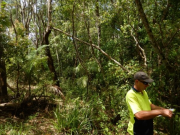
This dataset contains Vegetation and Biomass monitoring data collected for the NESP Project 2.1.4 (Demonstration and evaluation of gully remediation on downstream water quality and agricultural production in GBR rangelands). The aim of the vegetation monitoring in relation to this project is to track change in biomass and species composition over time on hillslope areas above gully erosion within control and treatment sites (treatments vary), linking to changes in downstream water quality.
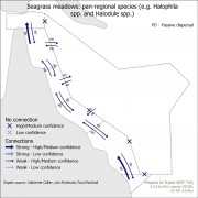
This dataset shows the results of mapping the connectivity of key values (natural heritage, indigenous heritage, social and historic and economic) of the Great Barrier Reef with its neighbouring regions (Torres Strait, Coral Sea and Great Sandy Strait). The purpose of this mapping process was to identify values that need joint management across multiple regions.
It contains a spreadsheet containing the connection information obtained from expert elicitation, all maps derived from this information and all GIS files needed to recreate these maps.
Data is from a series of instruments, including temperature loggers, weather stations and turbidity / salinity loggers deployed at four sites in the Torres Strait (Thursday Island – logger + weather station), Masig Island (logger + weather station), Bramble Cay (Maizab Kaur – logger + weather station) and the northern Warrior Reefs (turbidity and salinity) as part of a larger project to investigate the impact of Fly River discharge waters on the Torres Strait.
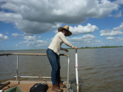
This data set contains high frequency logging data to measure water depth, water temperature and electrical conductivity in project wetland sites.
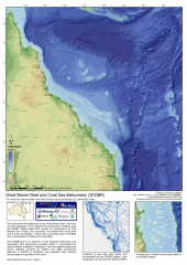
The gbr100 dataset is a high-resolution bathymetry and Digital Elevation Model (DEM) covering the Great Barrier Reef, Coral Sea and neighbouring Queensland coastline. This DEM has a grid pixel size of 0.001-arc degrees (~100m) with a horizontal datum of WGS84 and a vertical datum of Mean Sea Level (MSL).
For the latest version of this dataset download the data from http://deepreef.org/bathymetry/65-3dgbr-bathy.html
This dataset was developed as part of the 3DGBR project.
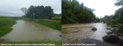
The dataset contains the particle size distribution analysis (on a Malvern Mastersizer 3000 laser diffraction) and major and trace element geochemistry data for end of river and flood plume samples from the 2017, 2018 and 2019 Burdekin flood events as well as for the 2017 and 2018 Tully flood events. Additional data are provided from the Ross River, Haughton River and Johnstone River.
* This dataset is currently under embargo.
This data set provides detailed information about the chemical composition, bioavailability and relative abundance of organic compounds in plant material and the organic associated with soil and sediment samples collected from terrestrial and marine environment of the Great Barrier Reef.
*This dataset is currently under embargo.
The second stream within the NESP 5.5 project was conducted using eye-tracking technology to examine possible differences between three participant groups in evaluating the aesthetic beauty of GBR underwater sceneries. This research continue the efforts initiated in the previous NESP 3.2.3 project to explore the power of eye-tracking as an objective measure of human aesthetic assessment of GBR underwater sceneries.
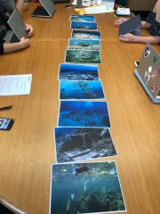
Organizing focus groups was used as an effective qualitative research method to examine collective opinions of participants on a specific topic. Within NESP 5.5 project, focus groups consist of an exploratory study to explore the psychological antecedents of human aesthetic assessment of underwater sceneries at the GBR among three groups of different cultural backgrounds: Chinese, non-indigenous Australians and First People Australians. Focus group folder contains one dataset report, and three folders (Australian, Chinese, First People) with seven images.
Methods:
This data set contains high frequency logging data to measure water depth, water temperature and electrical conductivity in project wetland sites. In addition fish catch data in wetlands recorded during this project, using electro-fish boat.

The dataset consists of tables of means, with statistical differences indicated where they are significant, for measured crop performance, fertilizer N recovery and use efficiency at 6 field sites from Mackay to Freshwater. Runoff losses of N are also shown from sites at Freshwater and Silkwood.
**This dataset is currently under embargo until December 2021.
This dataset contains the results of the water quality monitoring program conducted across the Russell-Mulgrave catchment (south of Cairns) for "Project 25". Project 25 spanned two (2) NESP TWQ projects: 2.1.7 (2016 - 2018) and 4.8 (2019 - 2020), with the dataset for Project 4.8 also containing the data for Project 2.1.7. Data is the result of discrete ‘grab’ samples analysed at TropWATER JCU laboratory for nutrients and sediments.
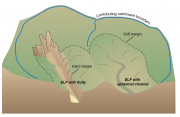
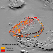
This dataset contains maps of alluvial and hillslope gullies across four large blocks of lidar covering portions of the Burdekin, Fitzroy, and Normanby Catchments. The gully polygons were generated using methods developed in the NESP 5.10 project for the extraction of gullies from lidar. Lidar is detailed topographic data collected from aircraft using an airborne laser scanning system.
The dataset represents the code base developed for the generation of water quality metrics from various data sources (eReefs Biogeochemical models, MODIS Satellite imaging and AIMS in situ sampling).
This metadata is a brief overview of the National Environmental Science Program Tropical Water Quality (NESP TWQ) Hub.
The aim of the National Environmental Science Programme (NESP) is to assist decision-makers to understand, manage and conserve Australia’s environment by funding world-class biodiversity and climate science.
The National Environmental Science Programme is delivered through six research hubs:
* Clean Air and Urban Landscapes Hub,
* Earth Systems and Climate Change Hub,
* Marine Biodiversity Hub,
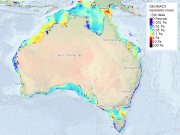
Geoscience Australias GEOMACS model was used to produce hindcast hourly time series of continental shelf (~20 to 300 m depth) bed shear stress (unit of measure: Pascal, Pa) on a 0.1 degree grid covering the period March 1997 to February 2008 (inclusive). The hindcast data represents the combined contribution to the bed shear stress by waves, tides, wind and density-driven circulation. The trimmed mean is simply the arithmetic mean calculated excluding a percentage of the highest and lowest values in the distribution.
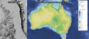
This dataset contains hillshading derived from the Digitial Elevation Model (DEM) dataset: Australian bathymetry and topography grid, June 2009 version 4 by Geoscience Australia. This dataset also contains the original DEM converted to a GeoTiff.
The hillshading was produced using the gdaldem tool.
The rest of this documentation is based on the metadata of the Australian bathymetry and topography grid itself. This grid is available from GA at http://dx.doi.org/10.4225/25/53D99B6581B9A .
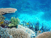
This dataset presents the raw data obtained from 1415 online and representative Australian that were asked to aesthetically rate 180 photos of typical coral reef landscapes. Mean aesthetic ratings of 180 photos were collected from the survey, as well as from an expert research team, contributing mean ratings of coral reef health, coral cover, coral pattern, coral topography, fish abundance, and visibility.
This project integrated all the available source bathymetry data currently used within the latest gbr100 grid and generated a much higher-resolution gbr30 bathymetry grid (~30 m pixel spacing) over the GBR shelf area. The gbr30 grid is recommended for use as a spatial dataset to feed into the Local and Regional Decision Support Tool (DST) being developed by CSIRO for Integrated Pest Management.
This dataset presents two excel spreadsheets containing the transect-based estimates of biomass carbon and condition score of study sites.