Mission Beach - Habitat Quality PDF Atlas (JCU)

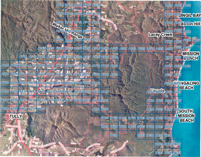
This atlas of 186 PDF maps shows the Habitat quality of the urbanized and agricultural regions of Mission Beach, Queensland based on aerial photography taken 6 months after cyclone Larry.

Each PDF map shows a 1km x 1km section and is approx 1.5-3 MB in size. To access the maps of interest view the index PDF and click on the region of interest. Note this only works if your browser is using an embedded Adobe Acrobat viewer such as Internet Explorer. If the links in the index.pdf don't work you can directly access the PDFs using the links below. Alternatively you can download the entire collection [Zip 373 MB] and browse it on your computer.

See the related dataset record for more information.

Mission Beach Index Map preview

AN14 AN15 AN16 AN17 AN18 AN26 AN27 AN28 AO14 AO15
AO16 AO17 AO18 AO26 AO27 AP14 AP15 AP16 AP17 AP18
AP26 AP27 AP28 AQ14 AQ15 AQ16 AQ17 AQ18 AQ26 AQ27
AQ28 AR14 AR15 AR16 AR17 AR18 AR26 AR27 AR28 AR29
AS12 AS13 AS14 AS15 AS16 AS17 AS18 AS19 AS20 AS21
AS22 AS23 AS24 AS25 AS26 AS27 AS28 AT10 AT11 AT12
AT13 AT14 AT15 AT16 AT17 AT18 AT19 AT20 AT26 AT27
AT28 AU08 AU09 AU10 AU11 AU12 AU13 AU14 AU15 AU16
AU17 AU18 AU19 AU20 AU26 AU27 AU28 AV08 AV09 AV10
AV11 AV12 AV13 AV14 AV15 AV16 AV17 AV18 AV19 AV20
AV26 AV27 AW08 AW09 AW10 AW11 AW12 AW13 AW14 AW15
AW16 AW17 AW18 AW26 AW27 AX08 AX09 AX10 AX11 AX12
AX13 AX14 AX15 AX16 AX17 AX18 AX19 AX24 AX25 AX26
AX27 AY08 AY09 AY10 AY11 AY12 AY13 AY14 AY15 AY16
AY17 AY18 AY19 AY24 AY25 AY26 AY27 AZ08 AZ09 AZ10
AZ11 AZ12 AZ18 AZ19 AZ24 AZ25 AZ26 AZ27 BA19 BA20
BA21 BA22 BA23 BA24 BA25 BA26 BA27 BB19 BB20 BB21
BB22 BB23 BB24 BB25 BB26 BC20 BC23 BC24 BC25 BC26
BD25 BD26 BD27 BE25 BE26 BE27