

NERP TE Project 1.2 - Marine wildlife management in the Great Barrier Reef World Heritage Area (JCU)
Project summary
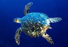
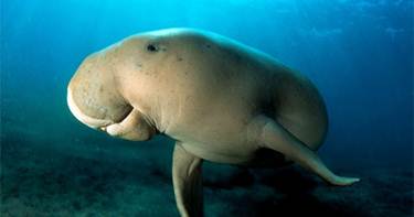
Marine mammals (dugongs and dolphins) and turtles are facing threats from human activities such as fishing, pollution and coastal development. This project will use monitoring, genetics, satellite tracking and remote sensing techniques to determine the distribution and status of inshore dolphins in the northern Great Barrier Reef World Heritage Area (GBRWHA); estimate the size of the dugong population along the GBRWHA coast; and better understand the role of green turtles and dugongs in coastal ecosystems. The project will also work with Traditional Owners to improve conservation of these species of conservation concern and high cultural value.
Why this research is needed
Managers of the Great Barrier Reef Marine Park need information about the current status and trends of marine species of conservation concern and how human activities such as fishing and coastal development affect populations of these species so they can be effectively managed.
Research-user focus
The project will deliver outcomes that are useful to a range of stakeholder and landholder organizations including State and Australian Government bodies, Traditional Owners, coastal developers, the tourism and fishing sectors and conservation planners/managers. Specific research-users include the Great Barrier Reef Marine Park Authority, Department of Sustainability, Environment, Water, Population and Communities and the Queensland Departments of Environment and Heritage Protection and Agriculture, Fisheries and Forestry.
Outcomes
The expected outcomes of the project include the following:
- Improved information about the population status of inshore dolphins, dugongs and marine turtles.
- Improved stakeholder understanding of the threats to these species and how these threats vary from place to place.
- Improved understanding of Traditional Owner issues relating to the management of the Great Barrier Reef; such as the sustainability of the traditional use of species of conservation concern.
- Improved understanding of non-Indigenous participants about traditional ecological knowledge and cultural aspects of marine wildlife management.
Reports
Sobtzick S, Hagihara R, Grech A, Marsh H. (2012) Aerial survey of the urban coast of Queensland to evaluate the response of the dugong population to the widespread effects of the extreme weather events of the summer of 2010-11. School of Earth and Environmental Sciences, ARC Centre of Excellence for Coral Reef Studies, James Cook University, Townsville, Australia.
Reports, Publications and News
For more information see Project 1.2 'Marine wildlife management in the Great Barrier Reef World Heritage Area' on the NERP Tropical Ecosystems Hub site.
Datasets
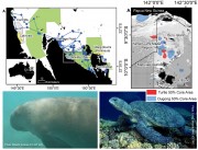
This dataset consists of the home ranges and satellite tracks taken from eleven dugongs and ten green turtles.
Methods:
Fast-acquisition satellite telemetry was used to track eleven dugongs and ten green turtles at two geographically distinct foraging locations in Queensland, Australia to evaluate the inter- and intra-species spatial relationships and assess the efficacy of existing protection zones. Home-range analysis and bathymetric modeling were used to determine spatial use and compared with existing protection areas using GIS.
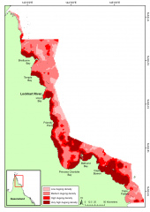
This dataset shows a raster spatial model of the distribution and relative density of dugongs (Dugong dugong) in the northern Great Barrier Reef region based on an aggregate of 24 years (1990 - 2013) of systematic aerial surveys.
Methods:
This project will monitor and study dugongs, dolphins and turtles along the coast of the GBRWHA with the following key tasks:
1. Determine the distribution and status of inshore dolphins in the northern Great Barrier Reef World Heritage Area (GBRWHA) by identifying likely important habitats based on collaboration with Tradition Owners and published information, then conduct line transect surveys (along with biopsy samples) in the Cardwell area (Girringun) and Bathurst Bay (far northern GBR).