

NESP TWQ Round 1 - Project 3.1 - Seagrass mapping synthesis - A resource for marine park and coastal management
Key to understanding the desired state of Queensland seagrasses is reliable data on seagrass distribution, abundance and species composition, and how this changes through time. Also valuable is the ability to reliably “drill” down from large-scale (World Heritage Area) to small-scale estuaries and meadows. TropWATER provides a composite map of seagrass for the GBRWHA available through eAtlas, GBRMPA and Pangaea. However this layer has not been updated since 2010 and is missing changes from important areas and extensive new data, and provides no meadow-specific information. This project will recompile existing GIS layers, update with 2010-2015 data, and provide meadow-specific information.
Datasets
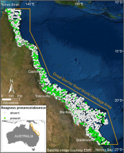
This dataset summarises 35 years of seagrass data collection (1984-2018) within the Great Barrier Reef World Heritage Area into one GIS shapefile containing seagrass presence and absence survey data for 81,387 sites.
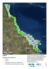
This dataset summarises 30 years of seagrass data collection (1984-2014) within the Great Barrier Reef World Heritage Area. The Site data describes seagrass at 66,210 sites; while the Meadow data describes seagrass at 1,169 individual or composite meadows. The data includes information on species, meadow type and age and reliability of the data. The dataset is available as shapefiles, GIS layer packages, and/or a CSV file. Data represented in this dataset has been collected by the TropWATER Seagrass Group and CSIRO in a GIS database.