
Ian McLeod
Author of
Published on 1 May 2013
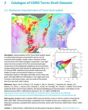
This milestone report presents a catalogue of information for the most significant and updated data sets, metadata and map compositions for the Torres Strait region, which may be suitable for inclusion in the Torres Strait eAtlas. The datasets included in this catalogue are described more fully in three previous reports. Pitcher et al 2004 collated all CSIRO seabed survey datasets prior to 2004 and integrated them to a common level of seabed habitat classification. Those datasets providing the broadest coverage of Torres Strait are included here.