
GeoServer Basics Training Workshop
The purpose of this workshop is to provide training for those that want to prepare GIS data for the e-Atlas or those who simply wish to learn how to use GeoServer to publish GIS data online. This workshop is not intended to be undertaken by researchers wanting to publish data on the e-Atlas. In that case you simply need to supply the data and prepare its documentation in accordance with the submitting data to the e-Atlas form.
This is a beginners workshop that should take half a day and assumes no experience with GeoServer. It does however assume that you are familiar with GIS data formats and concepts.
In this workshop you will learn about what the GeoServer does, how to use its interface, gain some of an awareness of the OGC web services it supports and a little on data preparation and styling. At the end of the workshop you will have a locally running copy of GeoServer that can be used to prepare data and styling. None of the content in this workshop is specific to the e-Atlas, it is a generic training workshop on GeoServer.
This workshop does not cover advanced topics such as data preparation for a wide variety of data types, advanced styling, linking WMS layers with metadata records, uploading prepared content to the e-Atlas.
What is GeoServer? Why would I use it?
GeoServer is an open source server for sharing geospatial data. It is designed for interoperability and excels at publishing any major spatial data source using open standards. With suitable preparation of data it excels at handling very large datasets, both raster and vector. It produces high quality rendering of maps and can handle hundreds to thousands of map layers easily.
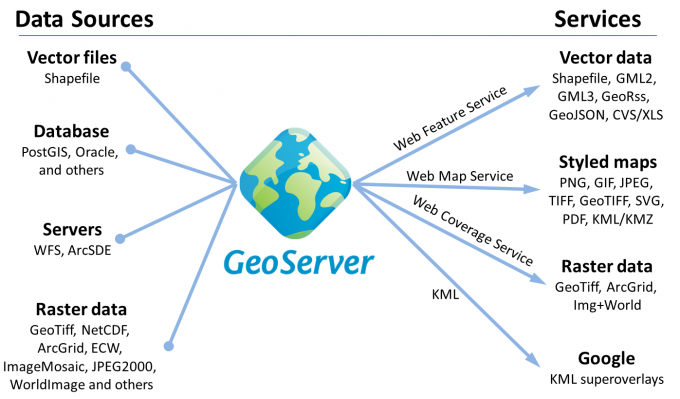
GeoServer can input spatial data in a wide variety of format and deliver them in a number of open standards based services.
Open Geospatial Consortium
The Open Geospatial Consortium (OGC) is an international voluntary consensus standards organization that originated in 1994. It consists of more than 400 commercial, governmental, nonprofit and research organizations worldwide to collaborate in a consensus process encouraging development and implementation of open standards for geospatial content and services, GIS data processing and data sharing.
The OGC standards comprises more than 30 standards that cover services including standards for delivering maps and spatial data online (WMS, WFS, WCS, WPS, KML), styling of spatial data (SLD), interacting with sensors (SOS, SensorML, SPS) and sharing of metadata catalogues (CSW).
The OGC standards have been widely adopted internationally as the primary source of open standards that should be adopted. Even proprietary software vendors such as ESRI are adding limited support for these standards.
In this workshop we will only focus on the Web Map Service (WMS) standard as it is the primary standard for delivering maps online.
National Environmental Information Infrastructure (NEII)
The National Plan for Environmental Information (NPEI) initiative is an Australian Government program intended to improve the quality and accessibility of environmental information for decision-making. This plan outlines the information infrastructure and standards that should be adopted by Government agencies when managing environmental data. The general principles of this plan are based on open access to data via open standards using open source software. A draft of the National Environmental Information Infrastructure Reference Architecture is now available and outlines GeoServer as the preferred software for delivering OGC mapping services because of its high quality implementation.
- What does it do? Why do I need it? What is it good at? What other products are there? Why would I use GeoServer?
- How does it compare with other map servers?
- Diagram showing changing spatial data into a range of services including WMS.
- Video demonstration of what is does.
- Key concepts: What is it, its role and why am I using it?
Installing GeoServer
- Focus on installation for local development not production.
- Key outcome: Working copy to try things out on. Ability to start and stop the service.
- Exercises: Installing GeoServer on Windows and starting it.