

Dr Eric Lawrey
Background
I completed a Bachelor of Computer Systems Engineering (Honours) from James Cook University (JCU) in 1997 followed by a PhD on modelling improved techniques for wireless communication, also at JCU, in 2001. After university I took up the position of Chief Technical Officer at Code Valley; a startup software engineering company researching a new way of developing software using distributed computing. In 2008 I joined the Australian Insitute of Marine Science (AIMS) as the developer of the eAtlas where I developed its architecture and software. In 2011 I took over as project leader for the eAtlas and now focus on data processing and stakeholder engagement.
Research Interests
My current research interest is in the design and development of the web platform behind the eAtlas that allows knowledge developed through environmental science to be spatially visualised and told as data driven stories. This work includes the development of web techology for delivery of the content, tools for processing environmental data and basemaps for the Great Barrier Reef, its catchments and the Torres Strait.
Author of
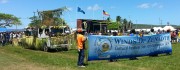
The Winds of Zenadth Cultural Festival takes place every two years on Thursday Island. The festival is a community event that brings people together and showcases the strength and diversity of the Torres Strait people’s culture and customs.
The eAtlas information stall at the festival in September 2014, provided an opportunity for the community to try out the mapping and visualisation tools and to get familiar with the look and feel of the site. The most important message for the community was that the Torres Strait eAtlas is an internet site that is free for everyone to use.
Over the life of the NERP TE program each project is required to complete a metadata describing the project itself and metadata records describing each of the dataset produced by the project.
This guide describes the creation and supplying of metadata describing just the project itself (referred to as the 'project metadata record') and not the datasets produced by this project; these will come later as each dataset is developed. These subsequent dataset records will be attached and linked to the project metadata record being described here.
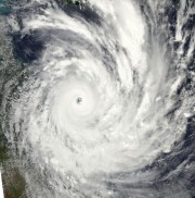
Severe Tropical Cyclone Yasi crossed the Queensland coast near Mission Beach on the night of the 2nd February 2011. This page shows satellite images (from NASA's MODIS satellites) of the disturbance to the Great Barrier Reef, damage to the vegetation in Mission beach and Cardwell area and flood plumes along the North Queensland coast.