
Datasets for: NERP TE Project 13.1 - eAtlas (AIMS)
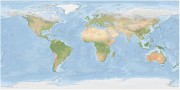
The Bright Earth eAtlas Basemap dataset collection is a satellite-derived global map of the world at a 1:1M scale for most of the world and 1:200k scale for Australia. This map was inspired by Natural Earth II (NEII) and NASA's Blue Marble Next Generation (BMNG) imagery.
Its aim was to provide a basemap similar to NEII but with a higher resolution (~10x).
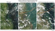
This collection is a record of MODIS satellite imagery before, during and after severe cyclone Yasi in February 2011. This image series highlights the damage the cyclone makes to the rainforest areas around mission beach and the turbulence created off shore by the cyclone on the 5th February (2.5 days after the cyclone). It corresponds to the images and maps from the "Cyclone Yasi satellite image maps - before and after" article in the eAtlas. Use this dataset if you wish to recreate these maps.
This layer shows a 500m resolution image of the world derived from the Blue Marble Next Generation April 2004 image (86400x43200 pixels).
As the image was derived from MODIS satellite imagery during Autumn in the Northern Hemisphere the high latitude countries (Russia, Canada, etc) are covered in snow.
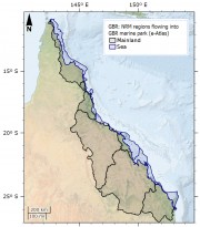
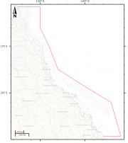
This dataset corresponds to the Natural Resource Management (NRM) Regions corresponding to river catchments neighbouring the Great Barrier Reef Marine Park. The original aim of this dataset was to show river basins that flow into the Great Barrier Reef (GBR) Marine Park, grouping them by their NRM region. The NRM region boundaries already mostly correspond to a grouping of river basin boundaries and so this regrouping of river basins was unnecessary.
This dataset corresponds to a reformatting of the SRTM30_PLUS digital elevation dataset from 33 NetCDF files into a single GeoTiff for use in GIS applications. No other modifications to the data were done. The rest of this metadata describes the original SRTM30_PLUS dataset itself.
Note: The SRTM15_plus dataset is a similar more recent, higher resolution bathymetry dataset https://topex.ucsd.edu/WWW_html/srtm15_plus.html.
This dataset consists of 107 days of vessel tracking using the Automatic Identification System (AIS) at 1 hour intervals extracted for the Queensland region from the Spatial@AMSA Historic Vessel Tracking website (AMSA 2013). It has been converted to Shapefile format and contains just under 1 million points.
This dataset is a composite of Landsat 5 satellite imagery to produce a cloud free, clear water seamless image of the Torres Strait region. This image includes some of Cape York and PNG, in particular the Fly river. This composite shows clear imagery for marine areas, in particular reefs, larger islands and sand bars.
This image has a resolution of approximately 30 m and a positional accuracy of better than 50 m.
This dataset shows the ocean side boundary of the Great Barrier Reef Marine Park, excluding the inner boundary along the Queensland coastline.
This dataset was derived from the Great Barrier Reef Marine Park Boundary dataset by loading the GBRMPA_BOUNDS_Line.shp (supplied by GBRMPA) into ArcMap then deleting the verticies along the coastline, breaking the original closed line loop.
This dataset is not authorive and was produced for use in the eAtlas. Contact the Spatial Data Centre at GBRMPA for the official boundaries.
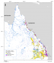
This dataset is subset and aggregation of the current Queensland land use dataset (1999 - 2012) by Queensland Land Use Mapping Program (QLUMP) produced by the Queensland Government. The land use data was classified and aggregated into areas that represent Human Use, Agriculture and Water areas such as lakes and rivers.
The eAtlas is a website and mapping system for presenting environmental research data in an accessible form that promotes greater use of this information. It is also a data management system for preserving and encouraging reuse of this data.
The eAtlas is the primary data and knowledge repository for 38 NERP Tropical Ecosystems Hub projects, 6 Reef Rescue Marine Monitoring Program projects and historically, the Marine and Tropical Science Research Facility. It is now funded as the data repository for the NESP TWQ hub.
Project goals under the NERP TE (2010 - 2014):
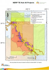
This dataset describes the areas of research activities for the 38 National Environmental Research Program Tropical Ecosystem (NERP TE) Hub projects. It represents the areas that have field work being conducted, where measurements have been taken and where modelling or analysis is being done.
It consists of three master shapefiles (points, lines and polygons) that capture the regions that are being studied by all these projects. These master shapefiles are also made available split by project.
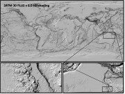
This dataset consists reprocessing and reformatting the SRTM30 PLUS v8.0 Digital Elevation Model (DEM) dataset developed by Scripps Institute Of Oceanography, University of California San Diego (UCSD) to produce a single raster covering the globe in GeoTiff format and create a full and low resolution hillshading from this DEM. The aim of this derived dataset is to reformat the data to allow easy use with GIS applications.
Full resolution hillshading: