 eAtlas Data Catalogue
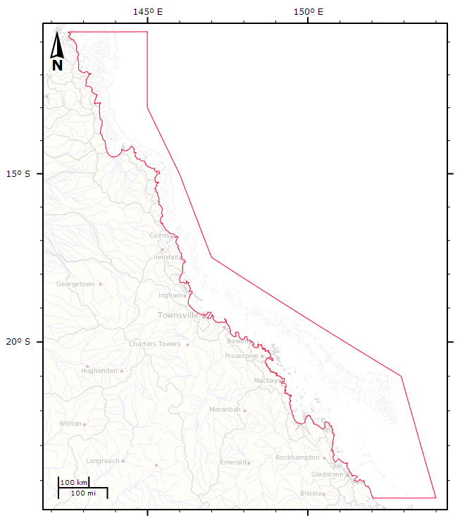
Great Barrier Reef Marine Park Boundary (GBRMPA)
Boundaries of the Great Barrier Reef Marine Park proclaimed under Subsection 31(1) of the Great Barrier Reef Marine Park Act 1975 (CTH). For administrative purposes, the Amalgamated Great Barrier Reef Section is divided into four management areas.
This metadata record was created for the eAtlas and is not authoritative. Please contact GBRMPA for more information. To obtain this dataset go to the GBRMPA spatial information website, download the appropriate data usage agreement and send it through to gis@gbrmpa.gov.au. gis@gbrmpa.gov This metadata record was created for the eAtlas and is not authoritative. Please contact GBRMPA for more information. To obtain this dataset go to the GBRMPA spatial information website, download the appropriate data usage agreement and send it through to gis@gbrmpa.gov.au.
Simple
Identification info
- Alternate title
- GBR_GBRMPA_GBRMP-boundary
- Alternate title
- GBRMP_BOUNDS_Line.shp
- Date (Publication)
- 2008-03-01T00:00:00
- Status
- Completed
- Spatial representation type
- Vector
- Topic category
-
- Boundaries
- Oceans
Extent
Extent
))
Extent
Extent
- Geographic identifier
-
GREAT BARRIER REEF
- Title
- ANZLIC Geographic Extent Name Register
- Date (Publication)
- 2006-10-10T00:00:00
- Edition
- Version 2
- Edition date
- 2001-02-01T00:00:00
- Citation identifier
- http://anzlicmet.bluenet.utas.edu.au/anzmetlite/mcp-allgens.xml#GREAT BARRIER REEF
- GCMD Science Keywords 5.3.8
-
- Human Dimensions | Boundaries | Administrative Divisions
- Oceans | Marine Environment Monitoring
- Keywords (Theme)
-
- marine
Resource constraints
- Use limitation
- © Commonwealth of Australia (Great Barrier Reef Marine Park Authority) The Data is subject to Copyright. Usage must comply with signed data usage agreement. Appropriate acknowledgement of the custodian must be created in all outputs. No third party usage is permitted without prior written consent of the custodian. For up to date licensing information please refer to: http://www.gbrmpa.gov.au/resources-and-publications/spatial-data-information-services/licensing-and-copyright-information
- Use constraints
- Copyright
Resource constraints
- Use limitation
- For up to date licensing information please refer to: http://www.gbrmpa.gov.au/resources-and-publications/spatial-data-information-services/licensing-and-copyright-information The following is an extract: 1. General Licensing Information The Great Barrier Reef Marine Park Authority (GBRMPA) is responsible for publishing the Great Barrier Reef Marine Park Authority’s official zoning maps. GBRMPA is also the custodian of spatial data relevant to Great Barrier Reef Marine Park Act 1975 and maintains an extensive and comprehensive collection of current reef and marine park spatial data covering the Great Barrier Reef Marine Park area. 2. Infringement of Copyright While GBRMPA wants to encourage the development and further use of GBRMPA spatial information, you must have GBRMPA’s written permission (a licence) before you can reproduce or publish any of GBRMPA 's spatial data. All GBRMPA publications and spatial data in whatever form or media are protected under the provisions of the Copyright Act 1968. For example, under the provisions of the Act, the Commonwealth’s copyright will be infringed if any person or organisation reproduces or publishes GBRMPA spatial data without having GBRMPA written permission in advance. The Commonwealth’s copyright will also be infringed if any spatial data is imported or sold or distributed in Australia, where that spatial data would infringe copyright if it had actually been made in Australia. If you do anything which infringes the Commonwealth’s copyright you will have stolen the results of GBRMPA work and GBRMPA will take legal action. Under the Copyright Act the Commonwealth may have the right to obtain injunctions, and an account of profits or damages. You may also be required to hand over any infringing copies. Copyright will be infringed whether reproduction: Is by hand or by any mechanical or electronic means Is based directly or indirectly on the Commonwealth’s spatial data Is from a map or a document or an electronic file. Copyright will not be infringed when reproduction constitutes a 'fair dealing' for the purpose of research or private study, or for the purpose of criticism or review or for the purpose of reporting news. However, the 'fair dealing' provisions are strictly limited. Copyright will not be infringed when the reproduction is done for the purpose of a judicial proceeding or for a report of a judicial proceeding. The Copyright Act may permit you to make a backup copy necessary for safeguarding electronic data, as long as the copy is kept and used only for that purpose. 3. Legal Advice You should get your own legal advice to find out if any proposed project in relation to using GBRMPA spatial data will or may infringe Commonwealth copyright if it is done without permission. 4. Licence Terms and Conditions The Commonwealth has prepared standard terms and conditions for granting access to its spatial data. These terms and conditions control the way you may exploit the spatial data. Your licence will set out exactly how you may exploit GBRMPA spatial data. The licence will state what spatial data you will be allowed to use and how it must be treated. Our licences cannot be used by or transferred to anyone else. However, GBRMPA may give you permission to engage someone else to assist you in your work. Where your use of GBRMPA spatial data is intended to create a derived product that will assist navigation, GBRMPA will only allow you to use the officially published charts and documents produced by the Australian Hydrographic Office (AHO) for this purpose. If you do not comply with the terms and conditions it will result in the termination of your licence.
- Use constraints
- License
- Language
- English
- Character encoding
- UTF8
Distribution Information
Distributor
- Fees
- GBRMPA has some fixed fees, some charges to cover GBRMPA's costs in preparing the spatial data for supply and GBRMPA may also charge royalties when GBRMPA spatial data is reproduced. GBRMPA licenses give GBRMPA the right to revise charges and fees from time to time.In some cases GBRMPA will charge a Licence establishment fee which is to pay for GBRMPA administration costs in processing your application and your licence. If you sell or distribute derived products or any other outcome from using GBRMPA spatial data, GBRMPA may charge you a royalty on each derived product or outcome that you supply. This includes any charges you make for supplying updated products or spatial data to customers. Where your derived products or services are distributed for in-house use (rather than sold to customers) royalties may still be payable. The royalty will be a fixed per centage of the net selling price of every derived product or outcome which you sell or distribute. GBRMPA will want you to send GBRMPA regular progress reports during the term of your licence including your audited sales and production figures. GBRMPA licences provide GBRMPA with the right to levy penalty interest on amounts that are outstanding.
- Ordering instructions
- To obtain this dataset go to the GBRMPA spatial information website, download the appropriate data usage agreement and send it through to gis@gbrmpa.gov.au.
- Title
- ESRI shapefile
- Date
- Edition
- 9.x
- Units of distribution
- MB
- Transfer size
- 1.24
- OnLine resource
- Spatial Data Information Services
- Medium format
- ISO9660 Rock Ridge
- OnLine resource
- Interactive map of the GBRMP boudaries and outer boundary
- OnLine resource
- ea:GBR_GBRMPA_GBRMP-boundary
- OnLine resource
- eAtlas Web Mapping Service (WMS) (AIMS)
Reference System Information
- Reference system identifier
- GDA94
Metadata
- Metadata identifier
- 1762af85-49a6-481c-a77d-105026b75b02
- Language
- English
- Character encoding
- UTF8
Point of contact
eAtlas Data ManagerAustralian Institute of Marine Science
Type of resource
- Resource scope
- Dataset
- Name
- series
- Metadata linkage
-
https://eatlas.org.au/data/uuid/1762af85-49a6-481c-a77d-105026b75b02
Point of truth URL of this metadata record
- Date info (Creation)
- 2015-12-10T16:24:43
- Date info (Revision)
- 2015-12-10T16:24:43
Metadata standard
- Title
- ISO 19115-3:2018
Overviews
Spatial extent
Provided by
