eAtlas Data Catalogue
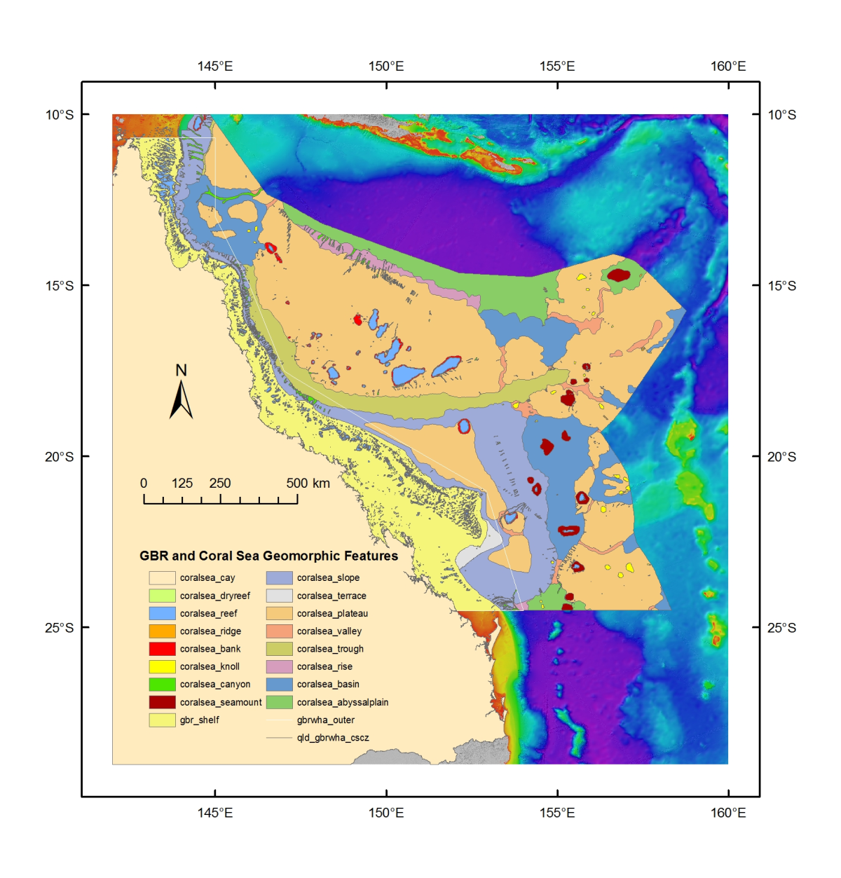
Project 3DGBR: Great Barrier Reef and Coral Sea Geomorphic Features (MTSRF 2.5i.1, JCU)
This phase of Project 3DGBR involved manual digitising of geomorphic map boundaries for the key seafloor features identified in the gbr100 grid, particularly for the inter-reefal area on the GBR shelf and in the Coral Sea Conservation Zone (CSCZ). See map for CSCZ boundary at: https://www.environment.gov.au/topics/marine/marine-reserves/coral-sea/conservation-zone
Methods:
GIS spatial analysis of the gbr100 grid was conducted in order to derive a number of useful background datasets for assisting in the digitising process, such as slope, aspect, hillshading, and dense contour lines.
The digitising initially focused on the deep-water (>100 m) environment to develop geomorphic maps for the continental slope, Queensland and Townsville Troughs lying within the Great Barrier Reef World Heritage Area (GBRWHA), and for the Queensland Plateau, Coral Sea Basin, Tasman Basin, and Lord Howe Rise area lying within the adjoining Coral Sea Conservation Zone (CSCZ). The project lastly focuses on the shallow-water (<100 m) environment to develop geomorphic maps for the GBR shelf to complement the shallow reef feature maps provided by GBRMPA. These shallow-water geomorphic features will be added to the project as they come available.
Format:
This dataset consists of 21 shapefiles and a GeoTiff raster file containing hillshading. Each of the shapefiles is described below.
Group Layer 1. Boundaries:
gbrwha_outer.shp
This Great Barrier Reef World Heritage Area (GBRWHA) layer was initially provided by GBRMPA using a GDA94 datum. The shapefile was reprojected to the WGS84 datum, and then the western coastline boundaries deleted to derive a line shapefile showing only the outer boundary of the GBRWHA where it extends away from the mainland.
qld_gbrwha_cscz.shp
This line shapefile combines both the GBRWHA and Coral Sea Conservation Zone (CSCZ) areas, with a western boundary limit at the Queensland mainland coastline. This area was used to clip all geomorphic features created in this project.
Group Layer 2. GBRMPA features:
gbr_dryreef.shp
The GBR shelf dryreefs shapefile was initially provided by GBRMPA for this project using a GD94 datum. The shapefile was reprojected to the WGS84 datum and not modified in any other way. It is provided here only for completeness but and products using this shapefile should also acknowledge GBRMPA (see under licensing).
gbr_features.shp
The GBR shelf features were initially provided by GBRMPA for this project using a GDA94 datum. The shapefile was reprojected to the WGS84 datum, and then the Ashmore Reef polygon deleted due to a grossly incorrect position. The shapefile comprises Cay, Island, Mainland, Reef, Rock and Sand features. Users may contact GBRMPA to obtain details for the creation of these features. Any products using this shapefile should also acknowledge GBRMPA (see under licensing).
Group Layer 3. Finer-scale features:
coralsea_cay.shp
Cay is a sand island elevated above Australian Height Datum (AHD), and located on offshore coral reefs and seamounts. Cays were mapped initially using a shapefile provided by Geoscience Australia for this project, and then their boundaries checked or remapped using Landsat imagery as background source data to help delineate the white sand areas against the surrounding ocean.
coralsea_dryreef.shp
Dryreef is rock/coral lying at or near the sea surface that may constitute a hazard to surface navigation. Dryreefs were mapped initially using a shapefile provided by Geoscience Australia for this project, which identified those reef areas lying above approximately Lowest Astronomic Tide (LAT). Landsat imagery was used as background source data to check or remap their boundaries.
coralsea_reef.shp
Reef is rock/coral lying at or near the sea surface that may constitute a hazard to surface navigation. For this project, the boundaries of reef areas were mapped to show the outer-most extent of each coral reef that could be observed in Landsat imagery, thus identifying the greatest area of each reef observed in the Coral Sea. This methodology is consistent with the methodology used to map the outer-most extents of reefs on the GBR shelf conducted by GBRMPA.
coralsea_ridge.shp
Ridge is a long, narrow elevation with steep sides. In this project, ridges were mapped as widely-scattered and uncommon, finer-scale features identified in the gbr100 grid. These elongate ridges are distinct from the smaller knolls or hills which have a more rounded shape. They are usually found on the plateaus of the Lord Howe Rise.
coralsea_bank.shp
Bank is an elevation over which the depth of water is relatively shallow but normally sufficient for safe surface navigation. In this project, banks were mapped as the base or pedestal boundaries of the coral reefs found in the Coral Sea. For example, the coral atolls and reefs on the Queensland Plateau are considered banks and their bases digitised where they emerge from the surrounding flat seafloor.
coralsea_knoll.shp
Knoll is a relatively small isolated elevation of a rounded shape. This shapefile also includes Abyssal hill, a low (100 – 500 m) elevation on the deep seafloor. For this project, knolls and abyssal hills were mapped using background datasets that showed relatively steep changes in elevation contours and variations in slope gradients. Knolls are numerous throughout the Coral Sea area and are greatly underestimated.
coralsea_canyon.shp
Canyon is a relatively narrow, deep depression with steep sides, the bottom of which generally has a continuous slope, developed characteristically on continental slopes. Canyons were mapped by closely following the narrow sides of canyon axes, digitising from the foot of the canyon where they merge with the surrounding basin floor, and up to the canyon head and into any connecting side gullies. This project identified numerous canyons on any slope gradient >1° and are also greatly underestimated across the area.
coralsea_seamount.shp
Seamount is a large isolated elevation >1000 m in relief above the seafloor, characteristically of conical form. This shapefile also includes Guyot, a seamount having a comparatively smooth flat top. Seamounts and guyots were mapped mostly within the Tasmantid Seamount Chain with elevations >1000 m. This project identified several large knolls and hills close to 1000 m in height within this chain that may also be seamounts but currently lack detailed bathymetry data.
Group Layer 4. Broader-scale features:
gbr_shelf.shp
Shelf is a zone adjacent to a continent (or around an island) extending from the low water line to a depth at which there is usually a marked increase of slope towards oceanic depths. The eastern boundary of the Queensland continental shelf was mapped by closely following the change in gradient along the shelf edge. The shelf break in the north was at approximately 80 m and became deeper at about 110 m towards the south. The western boundary was clipped at the Queensland mainland coastline.
coralsea_slope.shp
Slope lies seaward from the shelf edge to the upper edge of a continental rise or the point where there is a general reduction in slope. The continental slope was mapped lying adjacent to the shelf and extending into the adjacent deep basins and troughs. The shelf feature was used to erase the western boundary of the slope and the various basins and troughs erased the eastern slope border. The slope has extensive canyons incising its surface.
coralsea_terrace.shp
Terrace is a relatively flat horizontal or gently inclined surface, sometimes long and narrow, which is bounded by a steeper ascending slope on one side and by a steeper descending slope on the opposite side. In this project, one broad-scale terrace feature was mapped lying on the slope between the Swains Reefs and Capricorn-Bunker Group of reefs, and near the Capricorn Trough.
coralsea_plateau.shp
Plateau is a flat or nearly flat area of considerable extent, dropping off abruptly on one or more sides. Extensive areas of plateaus were mapped across the Coral Sea with the largest being the Queensland Plateau. Lord Howe Rise consists of a series of plateaus separated by broad-scale valleys linking adjacent basins and troughs. Plateau boundaries were mapped around their bases where the gradient first becomes steeper. The exceptions are the Marion and Saumarez Plateaus on the Queensland continental slope, where the boundaries were mapped as the slope gradient becomes flat or nearly flat.
coralsea_valley.shp
Valley is a relatively shallow, wide depression, the bottom of which usually has a continuous gradient. This term is generally not used for features that have canyon-like characteristics for a significant portion of their extent. The shapefile includes Hole, a local depression, often steep sided, of the seafloor. Valleys and holes were mapped as long shallow depressions that often separated the numerous plateaus. These features link the basins and troughs that surround these plateaus, and in some cases can be incised with finer-scale canyons.
coralsea_trough.shp
Trough is a long depression of the seafloor characteristically flat bottomed and steep sided and normally shallower than a trench. In this project, two trough features were mapped that are essentially long basins. The larger feature is a combined Queensland and Townsville Trough lying between the continental slope and the Queensland Plateau. The smaller feature is the Bligh Trough separating the northern slope and Eastern Plateau. Both trough features feed into the Osprey Embayment and huge Bligh Canyon.
coralsea_rise.shp
Rise is a gentle slope rising from the oceanic depths towards the foot of a continental slope. For this project, an elongate rise is mapped between the Queensland Plateau and the adjacent Coral Sea Basin. The Queensland Plateau is remnant continental crust from the Gondwana breakup and so its seaward edge provides a geomorphic extension of the Australian margin, albeit at a much deeper depth than the present mainland margin. The rise was mapped where the gradient angle of the Queensland Plateau seaward edge first becomes less steep and finishes at the Coral Sea Basin abyssal plain. Another rise feature was mapped between the southern continental slope and the Tasman Basin abyssal plain.
coralsea_basin.shp
Basin is a depression, characteristically in the deep seafloor, more or less equidimensional in plan and of variable extent. Basins were mapped where their boundaries changed from generally flat to more steep gradients. Plateau or slope features were used to erase and limit the boundaries of the basin features. In the north lies the large Osprey Embayment which has smaller plateaus lying within its area. The Cato Trough is a large basin separating the southern continental slope and plateaus of the Lord Howe Rise area. On the Lord Howe Rise are shallow basins that surround the series of plateaus that lie on the Lord Howe Rise.
coralsea_abyssalplain.shp
Abyssal plain is an extensive, flat, gently sloping or nearly level region at abyssal depths. Three abyssal plains were mapped where their gradients became generally flat and at depths greater than about 4000 m. In the north are the abyssal plains of the Coral Sea Basin and Louisiade Basin, the latter being a failed arm of a rift triple junction. In the south, lies the abyssal plain of the Tasman Basin.
Group Layer 5. Background image:
gbr100_geo3.tif
This hillshade geotif image was derived from the gbr100 grid using Fledermaus 3D visualization software with a depth colour scheme configured to highlight the physiographic relief of the shallow shelf and the deeper seabed features. It is provided here to give geomorphic context to the seabed areas lying outside of the GBRWHA and CSCZ.
Funding:
Queensland Government Smart Futures Fellowship
Reef and Rainforest Research Centre
James Cook University
References:
Heap, A.D., Harris, P.T., 2008. Geomorphology of the Australian margin and adjacent seafloor. Australian Journal of Earth Sciences 55(4), 555-585. doi: 10.1080/08120090801888669
IHO, 2008. Standardization of Undersea Feature Names: Guidelines, Proposal Form, Terminology. Bathymetric Publication No.6, 4th Edition, International Hydrographic Bureau/Intergovernmental Oceanographic Commission, Monaco, pp. 32.
Change log:
2023-01-10 - Updated the dataset download link from the original JCU link that is broken ( http://ftt.jcu.edu.au/deepreef/3dgbr/geo/3dgbr_geomorph.zip ) to a cached version hosted by the eAtlas.
2025-01-28 - Added persistent identifiers ORCID, RORs and issued a DOI for this record.
Simple
Identification info
- Date (Creation)
- 2012-02-15T00:00:00
- Date (Publication)
- 2012-02-15T00:00:00
Identifier
- Code
- 10.26274/8P0V-VW72
- Codespace
- doi.org
- Cited responsible party
-
Role Organisation Name Telephone Delivery point City Administrative area Postal code Country Electronic mail address Principal investigator James Cook University Beaman, Rob Voice facsimile PO Box 6811 Cairns Queensland 4870 Australia robin.beaman@jcu.edu.au
- Purpose
- Project 3DGBR aimed to develop a geomorphic classification of seabed habitat types based upon a suit of standard geomorphic descriptors of topographical and geological features (e.g. Heap and Harris, 2008; IHO, 2008). This work follows on from the development of the new 100 m-resolution bathymetry grid for the Great Barrier Reef (GBR) and offshore Coral Sea using all available data sources, called gbr100: http://www.deepreef.org/bathymetry/65-3dgbr-bathy.html These undersea landscape maps are required by marine managers to examine how effectively the current network of zoning protects the range of seabed habitats identified from the new depth model. A full description of Project 3DGBR is available at: http://www.deepreef.org/projects/48-depth-model-gbr.html
- Credit
- Morris, Sheriden (Reef & Rainforest Research Centre)
- Credit
- Souter, David (Reef & Rainforest Research Centre)
- Credit
- Susan Alexander (Great Barrier Reef Marine Park Authority)
- Status
- Completed
- Point of contact
-
Role Organisation Name Telephone Delivery point City Administrative area Postal code Country Electronic mail address Point of contact James Cook University Beaman, Rob Voice facsimile PO Box 6811 Cairns Queensland 4870 Australia robin.beaman@jcu.edu.au
- Spatial representation type
- Vector
Spatial resolution
- Spatial resolution
- 100
- Topic category
-
- Oceans
Extent
Extent
- Description
- Queensland, Great Barrier Reef and Coral Sea.
))
Temporal extent
- Time position
- 1971-08-03T00:00:00
- Time position
- 2009-10-29T00:00:00
- Keywords
-
- Oceans | Bathymetry | Seafloor Topography
- Keywords (Theme)
-
- marine
Resource constraints
- Use limitation
- NOT TO BE USED FOR NAVIGATION.
- Use limitation
- Cite this dataset as: Beaman, R. (2012). Project 3DGBR: Great Barrier Reef and Coral Sea Geomorphic Features (MTSRF 2.5i.1, JCU) [Data set]. eAtlas. https://doi.org/10.26274/8P0V-VW72
Resource constraints
- Linkage
-
http://i.creativecommons.org/l/by/2.5/au/88x31.png
License Graphic
- Title
- Creative Commons Attribution 2.5 Australia License
- Cited responsible party
-
Role Organisation Name Telephone Delivery point City Administrative area Postal code Country Electronic mail address
- Website
-
https://creativecommons.org/licenses/by/2.5/au/
License Text
- Other constraints
- © www.deepreef.org
- Other constraints
- NOTE: The gbr_features.shp and gbr_dryreef.shp under the Group Layer 'GBRMPA features' are Copyright to the Commonwealth of Australia (2007). Any products using these shapefile layers should show acknowledgement in the form of “Data courtesy of the Great Barrier Reef Marine Park Authority”.
- Language
- English
- Character encoding
- UTF8
Distribution Information
- OnLine resource
- Zipped folder [60 MB] with Geomorphic Features data (shapefile) and other media and documentation.
- Units of distribution
- Web Map Services
- OnLine resource
-
ea:GBR_JCU_3DGBR-geomorph_QLD-GBRWHA-CSCZ
This line shapefile combines both the GBRWHA and Coral Sea Conservation Zone (CSCZ) areas. GBRMPA supplied the original GBRWHA shapefile (detailed above). Geoscience Australia provided the original EEZ limit shapefile via the Australian Marine Spatial Information System (AMSIS). These two shapefiles were combined and clipped in the north at latitude 10°S. Note, this northern limit cuts off a small triangle of CSCZ over Ashmore Reef. The southern limit was clipped at latitude 24° 29.903'S. The western limit was clipped at the Queensland mainland coastline. This combined area was used to clip all geomorphic features created in this project.
- OnLine resource
-
ea:GBR_JCU_3DGBR-geomorph_Coralsea-plateau
Title: Coralsea Plateau Description: Plateau is a flat or nearly flat area of considerable extent, dropping off abruptly on one or more sides. Extensive areas of plateaus were mapped across the Coral Sea with the largest being the Queensland Plateau. Lord Howe Rise consists of a series of plateaus separated by broad-scale valleys linking adjacent basins and troughs. Plateau boundaries were mapped around their bases where the gradient first becomes steeper. The exceptions are the Marion and Saumarez Plateaus on the Queensland continental slope, where the boundaries were mapped as the slope gradient becomes flat or nearly flat.
- OnLine resource
-
ea:GBR_JCU_3DGBR-geomorph_Coralsea-abyssalplain
Abyssal plain is an extensive, flat, gently sloping or nearly level region at abyssal depths. Three abyssal plains were mapped where their gradients became generally flat and at depths greater than about 4000 m. In the north are the abyssal plains of the Coral Sea Basin and Louisiade Basin, the latter being a failed arm of a rift triple junction. In the south, lies the abyssal plain of the Tasman Basin.
- OnLine resource
-
ea:GBR_JCU_3DGBR-geomorph_Coralsea-rise
Rise is a gentle slope rising from the oceanic depths towards the foot of a continental slope. For this project, an elongate rise is mapped between the Queensland Plateau and the adjacent Coral Sea Basin. The Queensland Plateau is remnant continental crust from the Gondwana breakup and so its seaward edge provides a geomorphic extension of the Australian margin, albeit at a much deeper depth than the present mainland margin. The rise was mapped where the gradient angle of the Queensland Plateau seaward edge first becomes less steep and finishes at the Coral Sea Basin abyssal plain. Another rise feature was mapped between the southern continental slope and the Tasman Basin abyssal plain.
- OnLine resource
-
GBR_JCU_3DGBR-geomorph_Coralsea-reef
Reef is rock/coral lying at or near the sea surface that may constitute a hazard to surface navigation. For this project, the boundaries of reef areas were mapped to show the outer-most extent of each coral reef that could be observed in Landsat imagery, thus identifying the greatest area of each reef observed in the Coral Sea. This methodology is consistent with the methodology used to map the outer-most extents of reefs on the GBR shelf conducted by GBRMPA.
- OnLine resource
-
ea:GBR_JCU_3DGBR-geomorph_GBR-dryreef
The GBR shelf dryreefs shapefile was initially provided by GBRMPA for this project using a GD94 datum. The shapefile was reprojected to the WGS84 datum and not modified in any other way. It is provided here only for completeness but and products using this shapefile should also acknowledge GBRMPA (see under licensing).
- OnLine resource
-
ea:GBR_JCU_3DGBR-geomorph_Coralsea-terrace
Terrace is a relatively flat horizontal or gently inclined surface, sometimes long and narrow, which is bounded by a steeper ascending slope on one side and by a steeper descending slope on the opposite side. In this project, one broad-scale terrace feature was mapped lying on the slope between the Swains Reefs and Capricorn-Bunker Group of reefs, and near the Capricorn Trough.
- OnLine resource
-
ea:GBR_JCU_3DGBR-geomorph_GBR-features
Title: GBR: Features (GBRMPA) Description:The GBR shelf features were initially provided by GBRMPA for this project using a GDA94 datum. The shapefile was reprojected to the WGS84 datum, and then the Ashmore Reef polygon deleted due to a grossly incorrect position. The shapefile comprises Cay, Island, Mainland, Reef, Rock and Sand features. Users may contact GBRMPA to obtain details for the creation of these features. Any products using this shapefile should also acknowledge GBRMPA (see under licensing). Subcategory: 2. GBRMPA features
- OnLine resource
-
ea:GBR_JCU_3DGBR-geomorph_Coralsea-ridge
Ridge is a long, narrow elevation with steep sides. In this project, ridges were mapped as widely-scattered and uncommon, finer-scale features identified in the gbr100 grid. These elongate ridges are distinct from the smaller knolls or hills which have a more rounded shape. They are usually found on the plateaus of the Lord Howe Rise.
- OnLine resource
-
ea:GBR_JCU_3DGBR-geomorph_Coralsea-cay
Cay is a sand island elevated above Australian Height Datum (AHD), and located on offshore coral reefs and seamounts. Cays were mapped initially using a shapefile provided by Geoscience Australia for this project, and then their boundaries checked or remapped using Landsat imagery as background source data to help delineate the white sand areas against the surrounding ocean.
- OnLine resource
-
ea:GBR_JCU_3DGBR-geomorph_Coralsea-trough
Trough is a long depression of the seafloor characteristically flat bottomed and steep sided and normally shallower than a trench. In this project, two trough features were mapped that are essentially long basins. The larger feature is a combined Queensland and Townsville Trough lying between the continental slope and the Queensland Plateau. The smaller feature is the Bligh Trough separating the northern slope and Eastern Plateau. Both trough features feed into the Osprey Embayment and huge Bligh Canyon.
- OnLine resource
-
ea:GBR_JCU_3DGBR-geomorph_GBRWHA-outer
This Great Barrier Reef World Heritage Area (GBRWHA) layer was initially provided by GBRMPA using a GDA94 datum. The shapefile was reprojected to the WGS84 datum, and then the western coastline boundaries deleted to derive a line shapefile showing only the outer boundary of the GBRWHA where it extends away from the mainland.
- OnLine resource
-
ea:GBR_JCU_3DGBR-geomorph_Coralsea-slope
Slope lies seaward from the shelf edge to the upper edge of a continental rise or the point where there is a general reduction in slope. The continental slope was mapped lying adjacent to the shelf and extending into the adjacent deep basins and troughs. The shelf feature was used to erase the western boundary of the slope and the various basins and troughs erased the eastern slope border. The slope has extensive canyons incising its surface.
- OnLine resource
-
ea:GBR_JCU_3DGBR-geomorph_Coralsea-basin
Basin is a depression, characteristically in the deep seafloor, more or less equidimensional in plan and of variable extent. Basins were mapped where their boundaries changed from generally flat to more steep gradients. Plateau or slope features were used to erase and limit the boundaries of the basin features. In the north lies the large Osprey Embayment which has smaller plateaus lying within its area. The Cato Trough is a large basin separating the southern continental slope and plateaus of the Lord Howe Rise area. On the Lord Howe Rise are shallow basins that surround the series of plateaus that lie on the Lord Howe Rise.
- OnLine resource
-
ea:GBR_JCU_3DGBR-geomorph_Coralsea-bank
Bank is an elevation over which the depth of water is relatively shallow but normally sufficient for safe surface navigation. In this project, banks were mapped as the base or pedestal boundaries of the coral reefs found in the Coral Sea. For example, the coral atolls and reefs on the Queensland Plateau are considered banks and their bases digitised where they emerge from the surrounding flat seafloor.
- OnLine resource
-
ea:GBR_JCU_3DGBR-geomorph_Coralsea-dryreef
Dryreef is rock/coral lying at or near the sea surface that may constitute a hazard to surface navigation. Dryreefs were mapped initially using a shapefile provided by Geoscience Australia for this project, which identified those reef areas lying above approximately Lowest Astronomic Tide (LAT). Landsat imagery was used as background source data to check or remap their boundaries.
- OnLine resource
-
ea:GBR_JCU_3DGBR-geomorph_Coralsea-knoll
Knoll is a relatively small isolated elevation of a rounded shape. This shapefile also includes Abyssal hill, a low (100 – 500 m) elevation on the deep seafloor. For this project, knolls and abyssal hills were mapped using background datasets that showed relatively steep changes in elevation contours and variations in slope gradients. Knolls are numerous throughout the Coral Sea area and are greatly underestimated.
- OnLine resource
-
ea:GBR_JCU_3DGBR-geomorph_GBR-shelf
Shelf is a zone adjacent to a continent (or around an island) extending from the low water line to a depth at which there is usually a marked increase of slope towards oceanic depths. The eastern boundary of the Queensland continental shelf was mapped by closely following the change in gradient along the shelf edge. The shelf break in the north was at approximately 80 m and became deeper at about 110 m towards the south. The western boundary was clipped at the Queensland mainland coastline.
- OnLine resource
-
ea:GBR_JCU_3DGBR-geomorph_Coralsea-canyon
Canyon is a relatively narrow, deep depression with steep sides, the bottom of which generally has a continuous slope, developed characteristically on continental slopes. Canyons were mapped by closely following the narrow sides of canyon axes, digitising from the foot of the canyon where they merge with the surrounding basin floor, and up to the canyon head and into any connecting side gullies. This project identified numerous canyons on any slope gradient >1° and are also greatly underestimated across the area.
- OnLine resource
-
ea:GBR_JCU_3DGBR-geomorph_Coralsea-seamount
Seamount is a large isolated elevation >1000 m in relief above the seafloor, characteristically of conical form. This shapefile also includes Guyot, a seamount having a comparatively smooth flat top. Seamounts and guyots were mapped mostly within the Tasmantid Seamount Chain with elevations >1000 m. This project identified several large knolls and hills close to 1000 m in height within this chain that may also be seamounts but currently lack detailed bathymetry data.
- OnLine resource
-
ea:GBR_JCU_3DGBR-geomorph_Coralsea-valley
Valley is a relatively shallow, wide depression, the bottom of which usually has a continuous gradient. This term is generally not used for features that have canyon-like characteristics for a significant portion of their extent. The shapefile includes Hole, a local depression, often steep sided, of the seafloor. Valleys and holes were mapped as long shallow depressions that often separated the numerous plateaus. These features link the basins and troughs that surround these plateaus, and in some cases can be incised with finer-scale canyons.
- OnLine resource
- eAtlas Web Mapping Service (WMS) (AIMS)
- OnLine resource
- Interactive map of this dataset showing all 21 shapefiles.
Resource lineage
- Statement
- The geomorphic datasets were manually digitised against background datasets that were derived from the gbr100 grid (V2.0, 23 June 2011). An explanation of the gbr100 grid development may be found in the report: Beaman, R.J., 2010. Project 3DGBR: A high-resolution depth model for the Great Barrier Reef and Coral Sea. Marine and Tropical Sciences Research Facility (MTSRF) Project 2.5i.1a Final Report, MTSRF, Cairns, Australia, pp. 13 plus Appendix 1. Available at: http://www.deepreef.org/images/stories/publications/reports/Project3DGBRFinal_RRRC2010.pdf Additional background source data were Landsat imagery used to assist in digitising the boundaries of shallow-water geomorphic features, such as the coral reefs and sand cays. AUSTRALIAN HYDROGRAPHIC SERVICE NOTICE: Not to be used for navigation. Certain material in this product are reproduced under licence by permission of The Australian Hydrographic Service © Commonwealth of Australia 2010. All rights reserved. This information may not be copied, reproduced, translated, or reduced to any electronic medium or machine readable form, in whole or part, without the prior written consent of the Australian Hydrographic Service. GEOSCIENCE AUSTRALIA NOTICE: This gbr100 DEM incorporates data which are © Commonwealth of Australia (Geoscience Australia) 2010. The Commonwealth gives no warranty regarding the data's accuracy, completeness, currency or suitability for any particular purpose. This dataset has been compiled from a wide range of data sources of varying resolution and accuracy. The resulting gbr100 DEM has some reefs shifted by up to 500m in the Swain Reefs area, due to a lack of source bathymetry data.
- Hierarchy level
- Dataset
Reference System Information
- Reference system identifier
- EPSG/EPSG:4326
Metadata
- Metadata identifier
- urn:uuid/25685ba5-6583-494f-974d-cce2f3429b78
- Language
- English
- Character encoding
- UTF8
- Contact
-
Role Organisation Name Telephone Delivery point City Administrative area Postal code Country Electronic mail address Point of contact Australian Institute of Marine Science eAtlas Data Manager Voice PRIVATE MAIL BAG 3, TOWNSVILLE MAIL CENTRE Townsville Queensland 4810 Australia e-atlas@aims.gov.au
Type of resource
- Resource scope
- Dataset
- Metadata linkage
-
https://eatlas.org.au/data/uuid/25685ba5-6583-494f-974d-cce2f3429b78
Point of truth URL of this metadata record
- Date info (Creation)
- 2018-08-21T00:57:54
- Date info (Revision)
- 2025-01-28T10:24:00.32Z
Metadata standard
- Title
- ISO 19115-3:2018