 eAtlas Data Catalogue
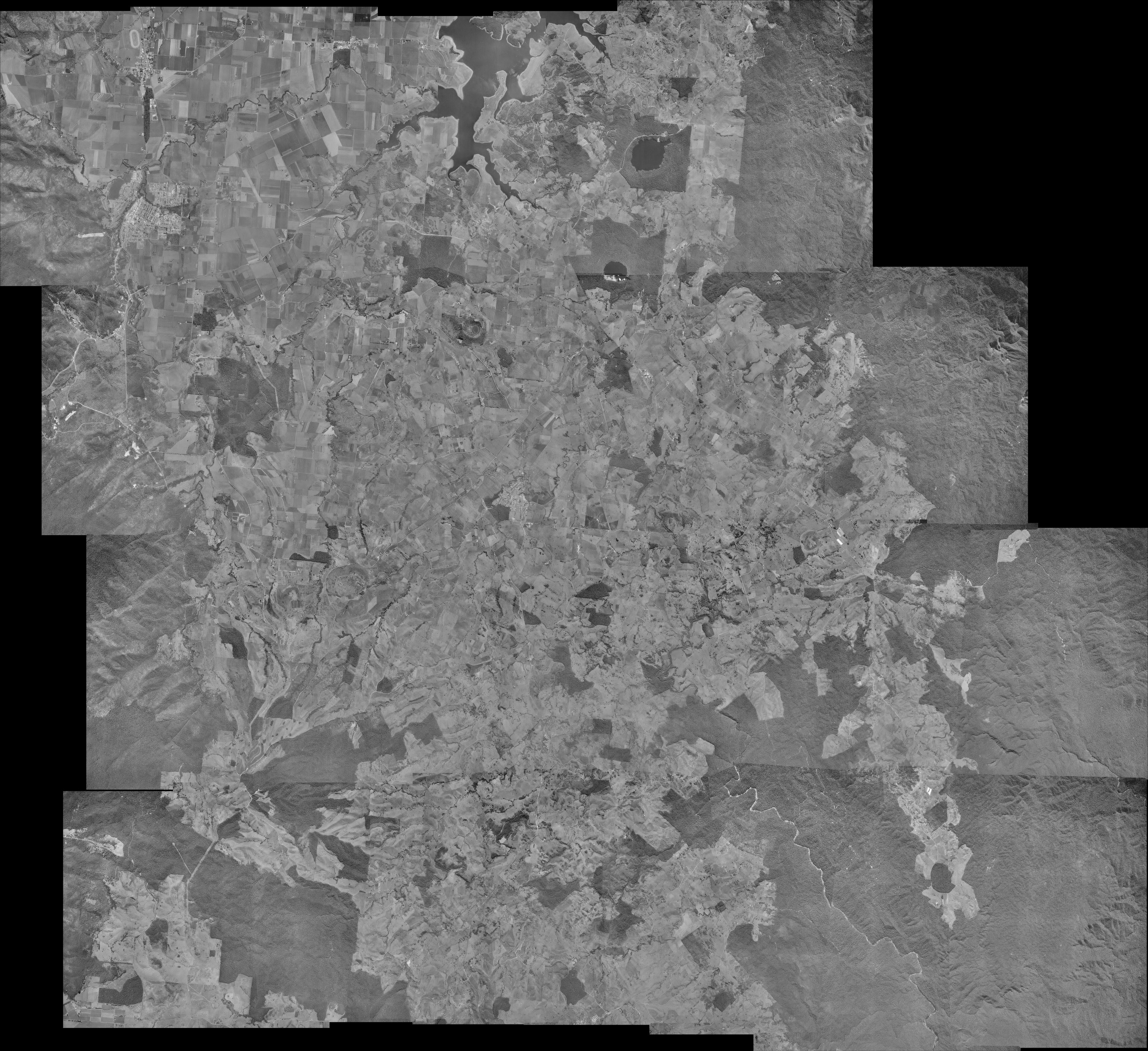
Aerial photo mosaic of Atherton Tablelands in June 1978 (NERP TE 12.2, Griffith, source: DERM)
This dataset is a photo mosaic of historic aerial imagery of the southern Atherton Tablelands from 16th June 1978.
It includes the towns of Atherton, Malanda, Yungaburra and Tolga. It has a southern boundary just north of Millaa Millaa, a northern boundary of Lake Tinaroo, an eastern boundary of a quarter of Wooroonooran National Park and a western boundary of Atherton.
This photo mosaic was compiled to assist in the location of rainforest regrowth areas for the NERP-TE project 12.2, Harnessing natural regeneration for cost-effective rainforest restoration (Griffith University, University of Queensland).
This photo mosaic was produced by Atherton Tablelands Geographical Information Services (ATGIS), April 2012, from digital data provided by Department of Environment and Resource Management (DERM), Queensland.
Aerial photography ownership; Department of Environment and Resource Management (Queensland). Aerial photography data is "© State of Queensland (Department of Environment and Resource Management) [2012]".
The photo mosaic is 13792x12623 pixels with a pixel size of 2.75mx2.75m and has a spatial reference of MGA55 (EPSG:28355). The original mosaic is stored in ECW format (18 MB). A GeoTiff version of the mosaic was created for the eAtlas (440 MB).
Simple
Identification info
- Alternate title
- WT_NERP-TE-12.2_Grif-DERM_Atherton-aerial-imagery-1978-06-16
- Date (Publication)
- 2012-04-01T00:00:00
Collaborator
Freebody, KylieAtherton Tablelands Geographical Information Services
Collaborator
Shoo, Luke, DrSchool of Biological Sciences, The University of Queensland (UQ)
Principal investigator
Catterall, Carla, Prof.School of Environment, Griffith University (GU)
Point of contact
Catterall, Carla, Prof.School of Environment, Griffith University (GU)
- Spatial representation type
- Grid
Spatial resolution
Equivalent scale
- Denominator
- 50000
- Topic category
-
- Imagery base maps earth cover
Extent
Extent
- Description
- Atherton Tablelands
))
Temporal extent
- Time position
- 1978-06-16T19:24:00
- Time position
- 1978-06-16T19:24:00
- Maintenance and update frequency
- Not planned
Resource constraints
- Linkage
-
http://i.creativecommons.org/l/by/2.5/au/88x31.png
License Graphic
- Title
- Creative Commons Attribution 2.5 Australia License
- Website
-
http://creativecommons.org/licenses/by/2.5/au/
License Text
- Other constraints
- This mosaic work is a digital product based on the "Digital Aerial Photography Area CD, 8063 Bartle Frere 1978 Program" by the Department of Environment and Resource Management (DERM) under a Single Supply License. Derivative products and copies of this work must display this acknowledgement: "Based on or contains data provided by the State of Queensland (Department of Environment and resource Management) [2012]. In consideration of the state permitting use of this data you acknowledge and agree that the State gives no warranty in relation to the data (including accuracy, reliability, completeness, currency or suitability) and accepts no liability (including without limitation, liability in negligence) for any loss, damage or costs (including consequential damage) relating to any use of the data. Data must not be used for direct marketing or be used in breach of the privacy laws." You must also include meta-data with the product(s) and include as a minimum the metadata provided with this supplied data.
- Language
- English
- Character encoding
- UTF8
Distribution Information
- OnLine resource
- NERP-TE Project 12.2 - Harnessing natural regeneration for cost-effective rainforest restoration (Griffith University)
- OnLine resource
-
ea:WT_UQ-Grif-DERM_Aerial-imagery-1978
WMS layer of aerial imagery 1978 of Atherton Tablelands
- OnLine resource
- eAtlas Web Mapping Service (WMS) (AIMS)
- OnLine resource
- Project web site
- OnLine resource
- Original mosaic of Atherton imagery in ECW format. (27MB)
Resource lineage
- Statement
- Photo mosaic produced by Atherton Tablelands Geographical Information Services (ATGIS), April 2012 1978 aerial photography imagery; digital data provided by Department of Environment and Resource Management, Queensland Photography Name: DERM-8063 Bartle Frere 78 Program Aerial Photography Digital data provided by DERM as scans of hard copy photos Aerial photography ownership; Department of Environment and Resource Management (Queensland). Aerial photography data is “© State of Queensland (Department of Environment and Resource Management) [2012]”. Date of aerial photography; 16/6/1978 Aerial photography resolution; 400 dpi jpeg Aerial photography scale; 1:49800
- Hierarchy level
- Dataset
Reference System Information
- Reference system identifier
- EPSG:28355
Metadata
- Metadata identifier
- urn:uuid/ce9d3908-9e7f-487d-9b58-bab5f2dfaff7
- Language
- English
- Character encoding
- UTF8
Point of contact
eAtlas Data ManagerAustralian Institute of Marine Science (AIMS)
- Parent metadata
Type of resource
- Resource scope
- Dataset
- Metadata linkage
-
https://eatlas.org.au/data/uuid/ce9d3908-9e7f-487d-9b58-bab5f2dfaff7
Point of truth URL of this metadata record
- Date info (Creation)
- 2015-09-28T14:40:27
- Date info (Revision)
- 2023-09-18T07:22:45
Metadata standard
- Title
- ISO 19115-3:2018
Overviews
Spatial extent
Provided by
