 eAtlas Data Catalogue
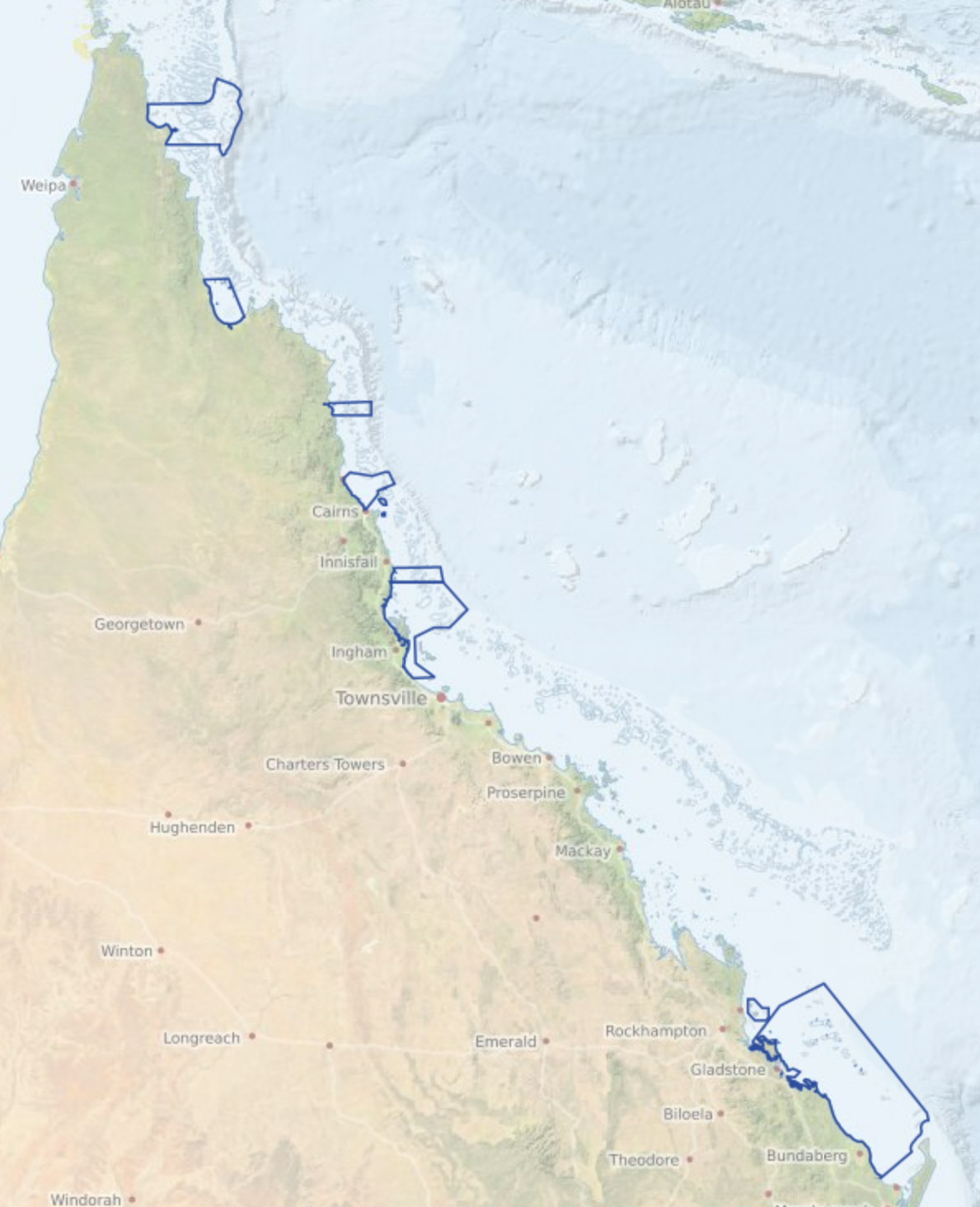
Traditional Use of Marine Resources Agreements (TUMRA) - 2020-03 (GBRMPA)
Traditional use activities in the Great Barrier Reef Marine Park are managed under the Great Barrier Reef Marine Park Act 1975, and the Great Barrier Reef Marine Park Regulations 2019. The Great Barrier Reef Marine Park Zoning Plan 2003 recognises that under section 211 of the Native Title Act 1993, native title holders may undertake traditional use of marine resources in the Great Barrier Reef Marine Park.
eAtlas Notes:
This is not the authoritative metadata for this dataset. The authoritative source is available from the GBRMPA data portal https://geoportal.gbrmpa.gov.au/datasets/GBRMPA::gbrmpa-traditional-use-of-marine-resources-agreement-tumra-areas. This metadata is retained in the eAtlas to include any additional notes and description about the dataset.
Traditional Use of Marine Resources Agreements are community-based plans for management of traditional resources which are accredited in legislation and have proved a successful mechanism for joint management of the Reef.
Traditional Use of Marine Resources Agreements describe how Great Barrier Reef Traditional Owner groups work in partnership with the Australian and Queensland governments to manage traditional use activities on their Sea Country.
Each Traditional Use of Marine Resources Agreements has a committee to manage the agreement and traditional use of marine resources in their Sea Country, including traditional take, if any of important species such as dugongs and turtles. Their management of traditional use is based on both cultural lore and contemporary science and are also used for broader Sea Country planning and management.
Description of the data:
The following are the list of TUMRAs included in this dataset:
- Dharumbal Region Woppaburra Section: Offshore area including the Keppel Islands Group and the surrounding waters.
- Girringun: Offshore area between Rollingstone and Mission Beach, including Hinchinbrook and Dunk Islands, but excluding the Palm Island Group.
- Wuthathi: Offshore area between Captain Billy Landing and the mouth of the Olive River, extending east past Raine Island.
- Port Curtis Coral Coast: Extending from the entrance of Port Alma south to Burrum Heads, including Curtis Island and the Capricorn and Bunker Island groups.
- Yuku Baja-Muliku: Monkhouse Point south to Forsberg Point and extending east to just past the Ribbon Reefs.
- Lama Lama: Near Massy Creek, east to Hedge Reef and south through Princess Charlotte Bay to the Normanby River in the south.
- Yirrganydji: Area between Port Douglas and Cairns, extending east past Spur, Onyx, Nicholas and Hope Reefs.
- Gunggandji: Green Island, Michaelmas Cay, Fitzroy Island, and the surrounding waters.
- Mandubarra: Offshore areas between the mouth of Mourilyan Harbour south to Kurrimine Beach, extending east past Armistice Reef.
Change Log:
2023-07-24 Dataset setup in eAtlas based on most recent available version of data from 2020-03-11
Simple
- Alternate title
-
TUMRA_areas
- Date (Publication)
- 2009-07-01
- Edition
-
v1.0
- Edition date
- 2009-07-01
- Presentation form
- Digital map
- Purpose
-
To show the spatial extent and location of the boundaries of areas covered under Traditional Use of Marine Resources Agreements (TUMRA).
- Credit
-
© Great Barrier Reef Marine Park Authority 2020
- Maintenance and update frequency
- As needed
- Keywords
-
-
Downloadable Data
-
- Keywords
-
-
boundaries
-
society
-
Indigenous
-
Traditional Owner
-
Great Barrier Reef
-
Great Barrier Reef Marine Park
-
management
-
- Use limitation
-
This work is licensed under a Creative Commons Attribution 4.0 International License.
- Spatial representation type
- Vector
- Metadata language
- English
- Character set
- UTF8
- Topic category
-
- Boundaries
- Society
- Environment description
-
Version 6.2 (Build 9200) ; Esri ArcGIS 10.6.0.8321
))
- Reference system identifier
- EPSG / 4283 / 8.3.4(3.0.1)
- Topology level
- Geometry only
- Geometric object type
- Composite
- Geometric object count
- 11
- Distribution format
-
-
File Geodatabase Feature Class
()
-
File Geodatabase Feature Class
()
- OnLine resource
- ref:GBR_GBRMPA_TUMRA_2020-03 ( OGC:WMS )
- OnLine resource
- GBRMPA: Original metadata and data download ( WWW:DOWNLOAD-1.0-http--download )
- OnLine resource
- Traditional Use of Marine Resources Agreements (GBRMPA) ( WWW:LINK-1.0-http--link )
- OnLine resource
- Interactive map of this dataset ( WWW:LINK-1.0-http--link )
- Hierarchy level
- Dataset
Quantitative attribute accuracy
- Measure description
-
Complete
Conceptual consistency
- Measure description
-
Consistent with coastline and islands database developed by the GBRMPA
Completeness omission
- Measure description
-
Dataset complete as of publication date.
Absolute external positional accuracy
- Measure description
-
Based on coordinates GDA94 and coastline developed by GBRMPA
- Statement
-
This dataset has been developed by the Great Barrier Reef Marine Park Authority (GBRMPA) on behalf of the Traditional Owners with use of marine resources agreements. The boundaries were developed through consultation with the Traditional Owners.
- File identifier
- e180cca5-d652-4292-8272-69ac94977e6b XML
- Metadata language
- English
- Character set
- UTF8
- Hierarchy level
- Dataset
- Hierarchy level name
-
dataset
- Date stamp
- 2023-08-09T06:16:25
- Metadata standard name
-
ISO 19139 Geographic Information - Metadata - Implementation Specification
- Metadata standard version
-
2007
Overviews
Spatial extent
Provided by
