 eAtlas Data Catalogue
2008
Type of resources
Topics
Keywords
Contact for the resource
Provided by
Years
Representation types
status
-
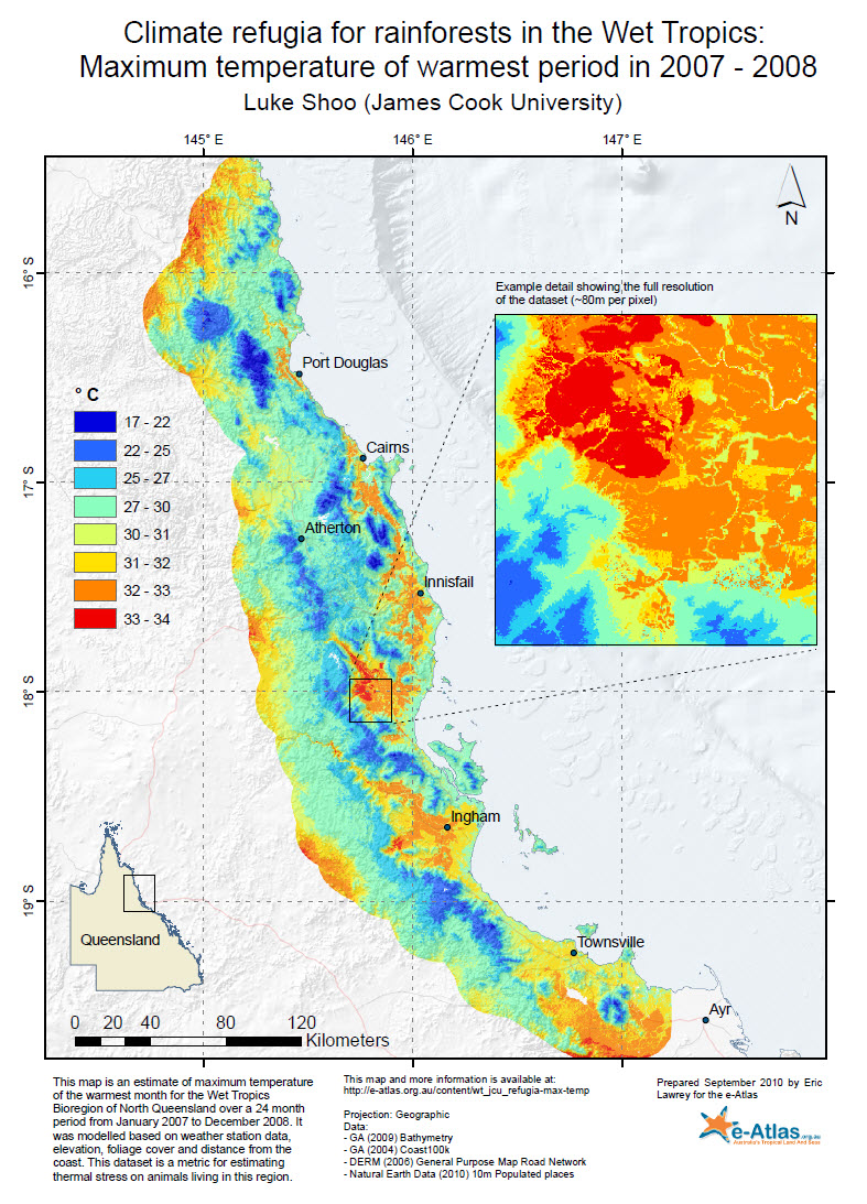
This dataset shows the estimated maximum temperature of the warmest period for the Wet Tropics Bioregion of North Queensland over a 24 month period from January 2007 to December 2008. It was modelled based on weather station data, elevation, foliage cover and distance to the coast. The purpose of this dataset is as a metric for estimating thermal stress on animals living in this region. Methods: The maximum temperate was modelled over the region at an 80 m resolution using weather station data with adjustments for elevation, foliage cover and distance from the coast. This allowed the temperature to be estimated for locations where there were no direct measurements of temperature. Models of the maximum temperature for each month of the study were generated. These 24 monthly surfaces were then overlaid and the maximum model temperature for any month was determined for each pixel to generate a summary variable - the maximum temperature of the warmest period (i.e., month). eAtlas Processing: The GeoTiff supplied with this dataset was produced as follows: gdal_translate csbc_05.asc -a_srs "EPSG:4283" -co "TILED=YES" -co "COMPRESS=LZW" -a_nodata -9999.0 WT_JCU_Refugia-max-temp_Jan2007-Dec2008.tif gdaladdo -r average WT_JCU_Refugia-max-temp_Jan2007-Dec2008.tif 2 4 8 16 32 64 Format: Data format ASCII Grid: 170MB, 4089 x 6372 pixels, GDA_94, 80 m resolution. This was converted by the eAtlas team to a 33 MB GeoTiff. References: A detailed description of data and methods are provided in: Shoo, L.P., Storlie, C., VanDerWal, J., Little, J., Williams, S.E. Targeted protection and restoration to conserve tropical biodiversity in a warming world. Global Change Biology, doi: 10.1111/j.1365-2486.2010.02218.x. Data Location: This dataset is filed in the eAtlas enduring data repository at: data\NERP-TE\4.2_Pesticide-effects\
-
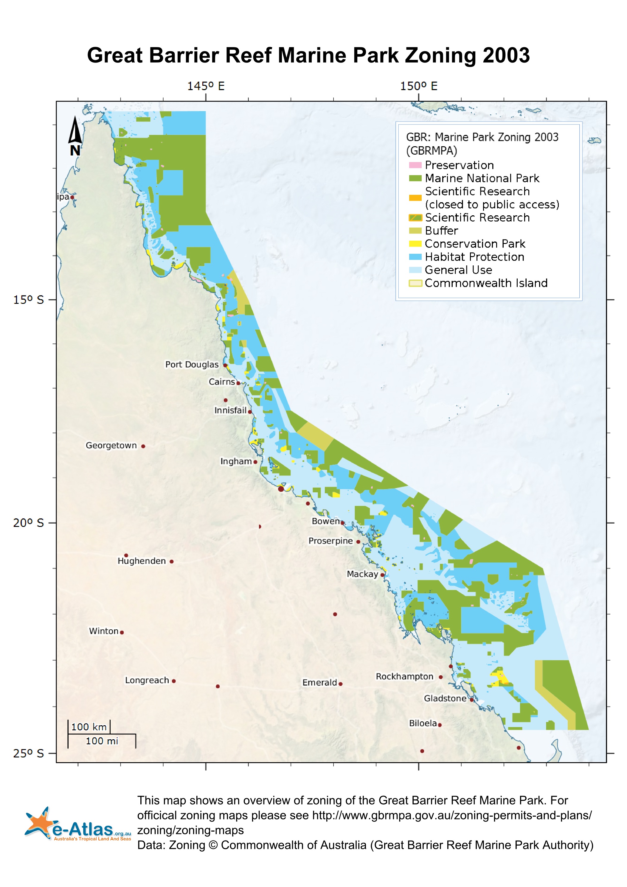
This dataset corresponds to the zoning within the Great Barrier Reef Marine Park effective 1st July 2004. It is derived from the Great Barrier Reef Marine Park Zoning Plan 2003. The Great Barrier Reef Marine Park is a multiple-use area. Zoning helps to manage and protect the values of the Marine Park that users enjoy. Zoning Plans define what activities occur in which locations both to protect the marine environment and to separate potentially conflicting activities. Revised zoning of the Great Barrier Reef Marine Park was introduced in July 2004 as part of the Great Barrier Reef Marine Park Authority's Representative Areas Programme. Between 1999 and 2004, the Great Barrier Reef Marine Park Authority undertook a systematic planning and consultative program to develop new zoning for the Marine Park. The primary aim of the program was to better protect the range of biodiversity in the Great Barrier Reef, by increasing the extent of no-take areas (or highly protected areas, locally known as ‘Green Zones’), ensuring they included 'representative' examples of all different habitat types - hence the name, the Representative Areas Program or RAP. Whilst increasing the protection of biodiversity, a further aim was to maximise the benefits and minimise the negative impacts of the rezoning on the existing users of the Marine Park. Both these aims were achieved by a comprehensive program of scientific input, community involvement and innovation [1]. In each zones there are a range of activities that are allowed, disallowed or require a permit. The following outlines a summary of activities that are disallowed in each zone. Please refer to [2] for a more detailed and authoritative description of all restrictions within each zone: * General Use Zone: General use, some activities require a permit. * Habitat Protection Zone: No trawling, some activities require permits. * Conservation Park Zone: No trawling, limited crabbing and line fishing. * Buffer Zone: No aquaculture, bait netting, crabbing, harvesting fishing, collecting, spearfishing, line fishing, netting and trawling. Trolling for pelagic fish is allowed. * Scientific Research Zone: Research areas primarily around scientific research facilities. Same as Buffer zone but with no trolling. * Marine National Park Zone (Green): 'no-take' area. The following are allowed: boating, diving, photography and limited impact research. Some other activities are allowed with permits. * Preservation Zone (Pink): 'no go' area. No activities are allowed except research activities with a permit. Official maps derived from this dataset can be downloaded from the GBRMPA Zoning Maps [3] page. This dataset can now be downloaded directly from GBRMPA's Geoportal. This metadata was prepared for the eAtlas and is not authoritative. Please contact the Great Barrier Reef Management Authority for an authoritative record. Data Location: This dataset is filed in the eAtlas enduring data repository at: data\other\GBR_GBRMPA_Zoning-2003