 eAtlas Data Catalogue
2014
Type of resources
Topics
Keywords
Contact for the resource
Provided by
Years
Formats
Representation types
Update frequencies
status
Scale
-
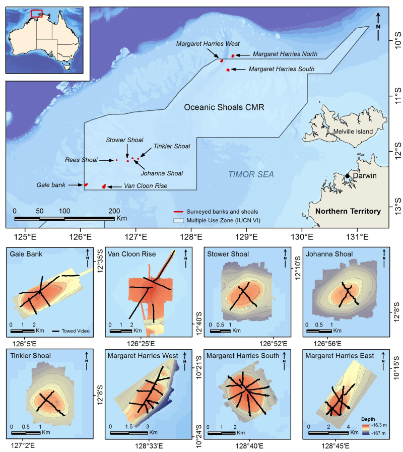
Towed video surveys between were carried out in targeted shallow seabed environments within and adjacent to the proposed Oceanic Shoals Commonwealth Marine Reserve (CMR) in the Timor Sea. The survey concentrated on shelf habitats (< 200m) of the Oceanic Shoals CMR and included potential biodiversity hotspots such as pinnacles, banks and shoals. In total, 48 towed video transects were collected at depths of between 17.2 and 89 metres. Sampling involved habitat classification, conducted in real-time during the surveys, and taking downward and forward facing photographic still images at 5 second intervals for subsequent analysis. The cameras were towed across the shoals at a speed of 0.5 - 1.5 knots at an altitude of 0.5 - 2 metres above the seabed. The survey was undertaken by the Australian Institute of Marine Science between May 8 and May 16 2014 on the AIMS Research Vessel, RV Solander, and aimed to address strategic knowledge gaps in the Oceanic Shoals bioregion.
-
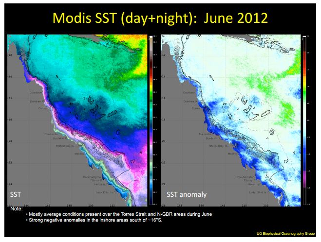
The Biophysical Oceanography Group produces monthly oceanographic reports for the eastern Australian coast, including the Torres Strait, which summarise key environmental variables such as sea surface temperature (SST) and chlorophyll concentration. These variables are important indicators for coral reef ecosystems and other biological processes. This series of the reports covers from August 2011 - November 2014 The NERP Torres Strait/GBR environmental condition reports have been assembled from an array of satellite and in situ data, as well as selected bleaching and temperature forecast models. These reports identify the differences between the models and observed conditions, and include a brief analysis of the ocean-atmospheric current conditions, from Pacific basin to GBR scale. The NERP reports cover Northern and Southern GBR and includes: - A monthly composite of SST, SST anomaly, chlorophyll-a and chlorophyll-a anomaly derived from MODIS imagery and processed by the Biophysical Oceanography Group; - Great Barrier Reef SST Anomaly Forecast (POAMA-2); - NOAA Coral Reef Watch outlook; - In-situ temperature measurements by the Australian Institute of Marine Science (AIMS) for Lizard Island, Davies Reef, Heron Island, Hardy Reed, Myrmidon Reef and Orpheus Island; - NOAA Optimum Interpolation Sea Surface Temperature Analysis - OceanMaps 15m Depth-Average Currents - ENSO index Historic reports go back to 2009. Note: The eAtlas does not contain the source data used to generate these reports. Repository Location: These reports have been filed in the eAtlas enduring data repository at: data\NERP-TE\2.3_TS-coral-monitoring\TS_NERP-TE-2-3_UQ_Condition-reports
-
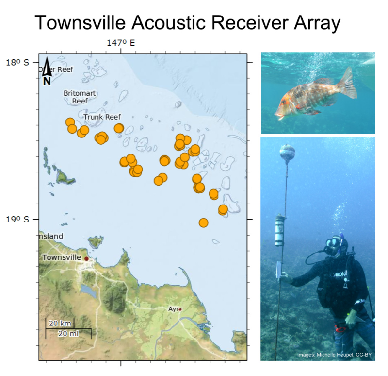
There are 3 datasets: 1. Acoustic array - this dataset includes a description of the acoustic array deployed on reefs offshore from Townsville. The array was in place from August 2011 to December 2014. 2. Individuals tagged - this dataset includes a description of the individuals fitted with acoustic transmitters for tracking on an acoustic array deployed on reefs offshore from Townsville. 3. Detection - this dataset includes detections of individuals fitted with acoustic transmitters. All detection data were collected within the Townsville reefs region, detection data come from individuals captured in the region or individuals that swam into this region from other study sites. Methods: An array of 48 Vemco VR2W acoustic receivers were deployed on 17 reefs offshore from Townsville, Qld to define presence and movement patterns of individuals fitted with acoustic transmitters. The number of receivers deployed per reef varied from 1 to 8. Reefs were selected to represent multiple Great Barrier Reef Marine Park Authority protection zones. Transmitters were deployed in 14 species of reef fish and sharks. The number of transmitters deployed varied among species. Individuals were captured and released between August 2011 and July 2014. All individuals were measured, fitted with an external identification tag and an acoustic transmitter. Individuals were released at their site of capture. Transmitter life varied with tag type. Teleosts received V13 tags that lasted 12 months, sharks received V16 tags that lasted 27 months. All transmitters were equipped with depth sensors to indicate the swimming depth of the individual. Transmitters functioned on 69kHz and emitted a coded signal once every 2 minutes. Movement patterns of individuals were tracked on an array of acoustic receivers. The focus of the research was individuals captured within the Townsville reefs region (Red Throat Emperor, Coral Trout, Reef Sharks, Tiger Sharks, Weasel Sharks), but the equipment also detects individuals captured in other locations that swim into this region. The detection data is inclusive of all individuals detected in this region. The receivers are fitted with new batteries once a year and are all still functional (Nov 2014). Data are downloaded twice per year with receivers lifted to the surface for a few minutes while the data are offloaded, batteries changed (when required) and then returned to their mooring. When large numbers of individuals or high environmental noise are present false detections can occur. Therefore the raw data may include detections of animals that are not authentic. All single detections need to be considered carefully prior to use for broad ranging conclusions. Detection data are limited by the range of each receiver, transmitter type and behaviour of individual fish. The detection range of each receiver in the array is approximately 400 - 900 m depending on environmental conditions such as wind and the tag transmitter power. Format: Acoustic array: Townsville Reef Receivers.CSV file (3 kb) Data Dictionary: - Receiver code: serial number - Reef: reef name - Latitude: decimal degree - Longitude: decimal degree - Zone: GBRMPA Zone Type. Latitude and longitude in WSG84 projection Individuals tagged: fish data_all.CSV file (53 kb) Data Dictionary: - Species: species code (code|common name|species mapping included in spreadsheet) - transmitter ID: code - Tag#: external tag number - Sex: sex (M/F) (where known) - PCL: ??? - FL: Fork length (in cm) - TL: total length (in cm) - Genetics: genetic sample ID number - Date: date captured - Reef: Reef of capture - Zone: GBRMPA Zone Type - CaptureLatitude: decimal degree - CaptureLongitude: decimal degree Latitude and longitude in WSG84 projection Detection: The detection data is available in two formats; a CSV file, Detection.CSV (427,938 kB), and the AATAMS database. The AATAMS database is the official repository and the place were new data will be made available first. The AATAMS database contains raw data files in a proprietary format (.vrl files). The database is fully searchable and provides the ability to export relevant data as csv files. The detection.CSV file is such an extract run 10-Dec-2015. The fields exported in detection.CSV are: Timestamp; station name; latitude; longitude; receiver id; tag ID; species; uploader; transmitter ID; organisation; sensor value; sensor unit. Data Location: This dataset is filed in the eAtlas enduring data repository at: data\NERP-TE\6.1_Mobile-predators
-

This dataset details the Declared Indigenous Protected Areas (IPA) across Australia through the implementation of the Indigenous Protected Areas Programme. These boundaries are not legally binding. An Indigenous Protected Area (IPA) is an area of Indigenous-owned land or sea where traditional Indigenous owners have entered into an agreement with the Australian Government to promote biodiversity and cultural resource conservation. The Indigenous Protected Areas element of the Caring for our Country initiative supports Indigenous communities to manage their land as IPAs, contributing to the National Reserve System. Further information can be found at the website below. http://www.environment.gov.au/indigenous/ipa/index.html Declared IPAs in order of gazettal date: Nantawarrina Preminghana Risdon Cove putalina Deen Maar Yalata Warul Kawa Watarru Walalkara Mount Chappell Island Badger Island Dhimurru Guanaba Wattleridge Mount Willoughby Paruku Ngaanyatjarra Tyrendarra Toogimbie Anindilyakwa Laynhapuy - Stage 1 Ninghan North Tanami Warlu Jilajaa Jumu Kaanju Ngaachi Great Dog Island Babel Island lungatalanana Angas Downs Pulu Islet Tarriwa Kurrukun Warddeken Djelk Jamba Dhandan Duringala Kurtonitj Framlingham Forest Kalka - Pipalyatjara Boorabee and The Willows Lake Condah Marri-Jabin (Thamurrurr - Stage 1) Brewarrina Ngemba Billabong Uunguu - Stage 1 Apara - Makiri - Punti Antara - Sandy Bore Dorodong Weilmoringle Yanyuwa (Barni - Wardimantha Awara) Minyumai Gumma Mandingalbay Yidinji Southern Tanami Angkum - Stage 1 Ngunya Jargoon Birriliburu Eastern Kuku Yalanji Bardi Jawi Girringun Wilinggin Dambimangari Balanggarra Thuwathu/Bujimulla Yappala Wardaman - Stage 1 Karajarri - Stage 1 Nijinda Durlga - Stage 1 Note: This record is a copy from the Department of the Environment for use in the eAtlas. For the latest version of this dataset check the Department of the Environment website.
-
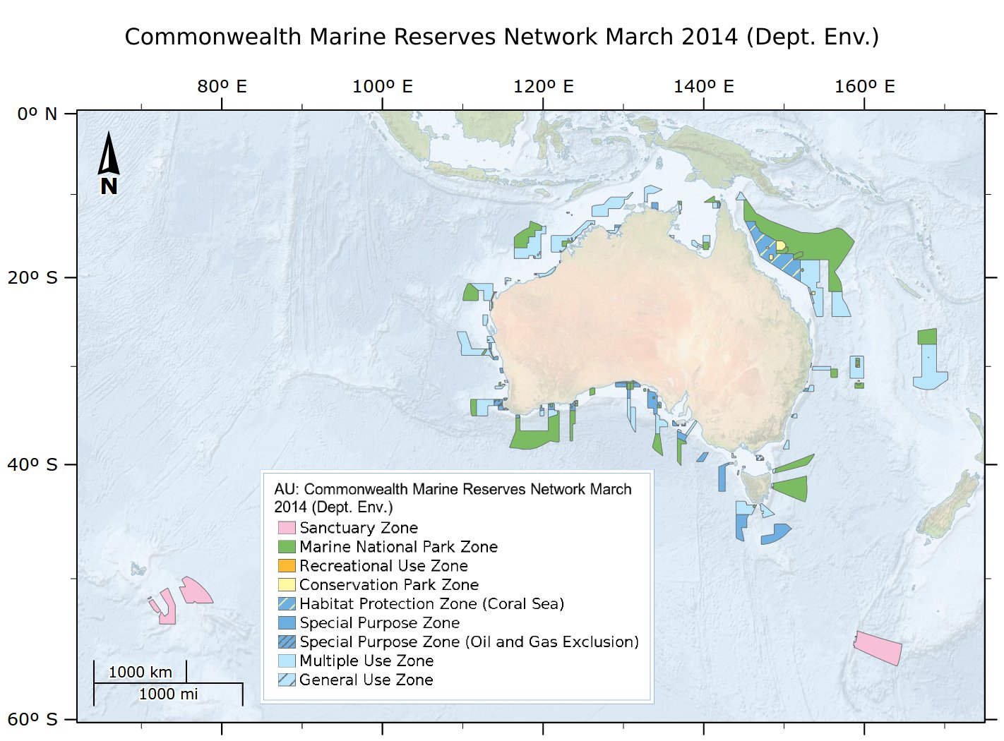
This dataset is not the current marine park zoning. It is retained here for historic purposes. See http://www.environment.gov.au/fed/catalog/search/resource/details.page?uuid=%7BCD8877F3-8C39-4A20-A53F-070FBEE5AF3C%7D for current zoning. Consistent with the Australian Government's commitment to develop a National Representative System of Marine Protected Areas (MPAs), networks of Commonwealth Marine Reserves have been proclaimed for Commonwealth waters across the South-west, North-west, North, Coral Sea and Temperate East Marine Regions. These networks build on previous Marine Protected Area proclamations, including the South-east network declared in 2007. This dataset is released under Creative Commons by Attribution-NonCommercial 3.0 Australia (CC BY-NC 3.0). IMPORTANT INFORMATION FOR MARINE USERS Transitional arrangements apply to the South-west, North-west, North and Temperate East Networks and the Coral Sea reserve, until management plans come into effect. These arrangements involve NO CHANGES ON THE WATER for marine users. Note, there are no changes to management arrangements in the marine reserves that existed prior to the establishment of the new reserves, that is, the same restrictions on activities will continue to apply even where those reserves have been incorporated into new reserves. The South-east Network of Commonwealth Marine Reserves is managed under the South-east Commonwealth Marine Reserves Network Management Plan 2013-23, in place from 1 July 2013. More information is available at www.environment.gov.au/marinereserves This data contains spatial and contextual information about Commonwealth Marine Reserves under the jurisdiction of the Commonwealth governments Environment Protection and Biodiversity Conservation Act 1999, which are managed by the Australian Government Department of the Environment. It does not include data on MPA's in other Australian jurisdictions (e.g. the Great Barrier Reef Marine Park, State/Territory parks), or Terrestrial Protected Areas with marine components (eg Pulu Keeling National Park). This is an extract of the full metadata record supplied by the Department of the Environment with this dataset. See http://www.environment.gov.au/fed/catalog/search/resource/details.page?uuid=%7B0435E716-1798-467C-8F43-E0CB6B32E8EF%7D for more information. eAtlas Change Log: 2023-04-04 - Marked the metadata as superseded. Fixed the link to the official data download. Updated the modification date. Changed the copyright from '© Commonwealth of Australia, Australian Government Department of the Environment, 2014' to the current '© Commonwealth of Australia, Australian Government Department of Climate Change, Energy, the Environment and Water, 2014'. Copied over additional lineage. Corrected the licensing from CC BY-NC 2.5 to CC BY-NC 3.0 eAtlas notes: This dataset is cached in the eAtlas enduring data repository at: data\non-custodian\pre-2015\AU_DotE_Comm-marine-reserves-2014