 eAtlas Data Catalogue
GIS
Type of resources
Topics
Keywords
Contact for the resource
Provided by
Years
Formats
Representation types
Update frequencies
status
Scale
-
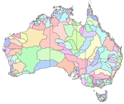
Australia's River Basins 1997 is the result of a joint State, Territory and Commonwealth Government project to create a national spatial database of major hydrological basins. It shows the boundaries of Australia's basins as defined by the Australian Water Resources Management Committee (WRMC). Australia is divided into drainage divisions which are sub-divided into water regions which are in-turn sub-divided into river basins. The data includes the name and number of each of the 245 drainage basins, 77 regions, and 12 divisions. This metadata was prepared for the eAtlas and is not authoritative. Please contact the custodian for an authoritative record. Data Location: A copy of this dataset is filed in the eAtlas enduring data repository at: data\other\AU_GA_River-basins-1997
-
Geoscience Australia has the primary role in the delineation of Australia's maritime boundaries. An output of this activity is the development of the Australian Maritime Boundaries (AMB) data. AMB is a GIS data product, replacing AMBIS 2001 Version 1.1, providing access to the data for Australia's Territorial Sea Baseline (TSB) and maritime zones. Note: This is a non authoritative copy of the metadata for the use in the eAtlas. Please refer to Geoscience Australia for queries on this dataset. This version of the dataset is now superseded by the Seas and Submerged Lands Act 1973 - epoch AMB2014a dataset. AMB is a digital representation of Australia's territorial sea baseline and boundaries as established under the Seas and Submerged Lands Act 1973. The data also include a representation of the limits by which the adjacent areas of each of the States and of the Northern Territory are determined under the Petroleum (Submerged Lands) Act 1967. In the event of an inconsistency between AMB data and the baseline and limits under the legislation, the latter prevails. The data have been published by Geoscience Australia in consultation with other relevant Commonwealth Government agencies including the Attorney-General's Department, the Department of Foreign Affairs and Trade and the Australian Hydrographic Office. AMB data comprise the TSB and the outer limits of each zone, together with maritime boundaries determined by treaties between Australia and neighbouring countries. Base points that generate the zone boundaries are supplied in separate files and an extensive user guide provides useful background information. All data coordinates are supplied in the World Geodetic System (WGS 84) (ITRF 2000 @ 2000.0) which is effectively identical to the GDA94 datum. Geoscience Australia is committed to the maintenance of the maritime boundaries data to ensure it reflects the changing nature of Australia's coastline and hence the various maritime zone limits. The data reflects the location of the coastline within the constraints of available source material at the time of production. Where major differences have since been discovered, these are listed in a table of notes and cautions. Note: This is a non authoritative copy of the metadata for the use in the eAtlas. Please refer to Geoscience Australia for queries on this dataset.
-
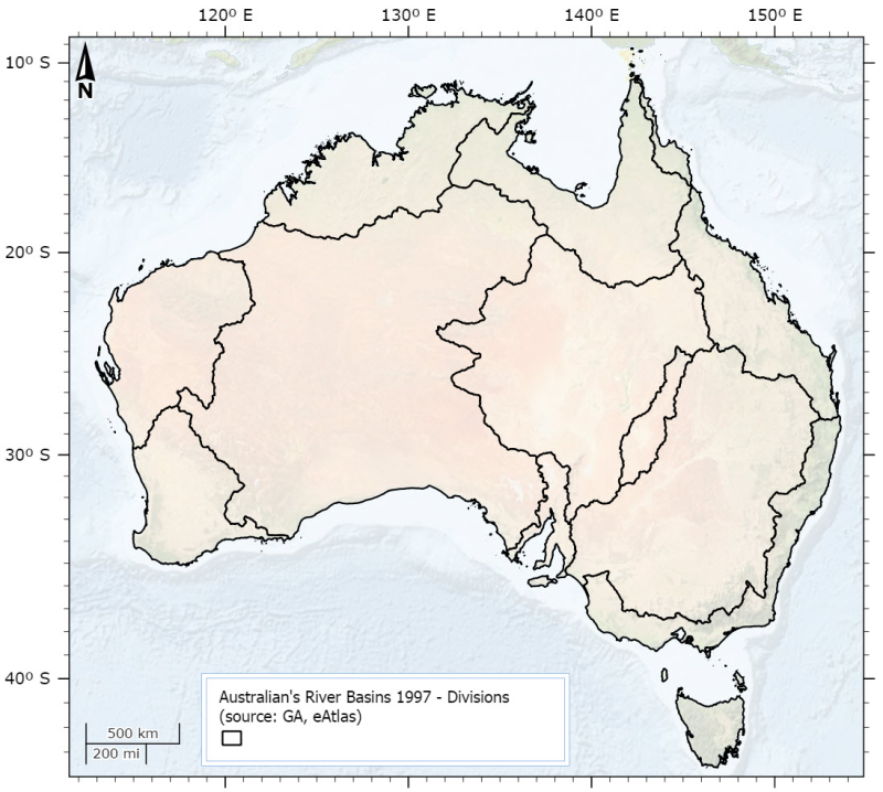
This dataset is derived from the Australia's River Basins 1997 (GA) dataset. It shows the 12 drainage divisions. Primary credit should be given to Geoscience Australia. This dataset was created by using ArcMap to dissolve polygons from the Australia's River Basins 1997 shapefile based on the DNAME attribute.