 eAtlas Data Catalogue
economy
Type of resources
Topics
Keywords
Contact for the resource
Provided by
Years
Formats
Representation types
Update frequencies
status
Scale
-
This project involved working with a range of stakeholders to identify the most effective governance systems for managing climate change adaptation in the Wet Tropics through the emergence of new ecosystem service markets, including Carbon Farming. The project will directly contribute to: Regional climate change adaptation policies and planning processes, Regional Natural Resource Management (NRM) organisations’ role in guiding emerging carbon markets in Australia and the region. This project developed: 1. Detailed Practical Manuals for NRM Bodies concerning planning and carbon market integration in place and training delivered across Queensland regional NRM bodies. 2. Defined partnership arrangements for refinement of Governance systems, institutional and planning reforms maintained. 3. Theory based publication on governance systems required for application of ecosystem service market activities against NRM plan objectives.
-
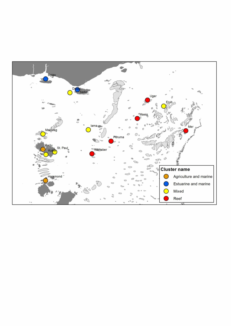
Determining the impact on Torres Strait communities from future changes to ecosystems requires an understanding of the natural resource base that underpins their livelihoods. To do this, we estimate the relative importance of natural resources, or ecosystem goods and services (EGS) to local livelihoods, which in turn is a function of the relative volume of those EGS, and their relative value to human well-being. Our approach was focused on 'provisioning' and 'cultural' EGS, which have a direct link to local livelihoods. This analysis considers the Production of EGS to each of the 14 Torres Strait Protected Zone communities (plus Hammond Island). These were quantified through ranking on a scale of 0 (does not exist) to 5 (largest quantity or volume) with the input of TSRA Land & Sea Management Unit officers with experience of the Torres Strait region's communities: Vic McGrath and Frank Loban. This provided the basis for determining community 'typologies' (i.e. communities that have a similar natural resource base). Using information from the literature on Torres Strait Island communities' livelihoods, plus the TSRA expert knowledge, we formulated a list of 27 significant EGS for Torres Strait. These were then ranked for each community by the TSRA team. This information was then used to produce an overall average EGS Volume ranking for all communities, and for determining community typologies in terms of their EGS resource base. Overall, coastal, pelagic and reef associated finfish, and green turtles had the greatest EGS Volume scores. The top 9 ranked EGS were marine resources, highlighting the strong connection between Torres Strait communities and their 'sea country'. Clustering of EGS Volume scores produced four community types at a distance metric of approximately 1. These were: - Reef: A group mostly made up of eastern and central islands (excluding Erub), and strongly separated from the remaining Torres Strait communities due to a relatively high volume of Reef resources, and low Production of Estuarine resources; - Agriculture and Marine: A group consisting of Badu and Hammond Island only, characterised by high volume of all resources, and relatively low volume of reef associated resources; - Estuarine and marine: A group consisting of Boigu and Saibai, with high volume of estuarine and marine resources, but low volume for most others; - Mixed: A large (and diverse) group of six widespread islands with medium volume for all resources. Method: We formulated a list of 27 significant ecosystem goods and services (EGS) for Torres Strait communities by reviewing the literature and interviewing several natural resource managers in TSRA and AFMA with appropriate expert knowledge. These EGS were then ranked for each community by the expert team through ranking on a scale of 0 (does not exist) to 5 (largest quantity or volume). The data were transformed with sqrt (x / 100), which has the desirable effect of reducing the influence of EGS used by few villages. Agglomerative hierarchical clustering using Ward's clustering criterion was performed with the 'hclust' function of the R statistical package (R Core Team 2013). The resulting dendrogram was reordered based on a PCA of the same data. This information was then used for determining community typologies in terms of their EGS resource base. For more information see the publication: Skewes, T., Rochester, W., Butler, J.R.A., Busilacchi, S., Hunter, C., McGrath, V. and Loban, F. 2012. Preliminary Identification and Valuation of Ecosystem Goods and Services Underpinning Torres Strait Livelihoods. NERP Tropical Ecosystems Hub Project 11.1 Milestone Report, June 2012. http://www.nerptropical.edu.au/Project11.1MilestoneReport-May2012-Preliminaryidentication References: Butler, J.R.A., Bohensky, E., Skewes, T., Maru, Y., Hunter, C., Busilacchi, S., Rochester, W., Johnson, J. and Doupe, J. (2012) Torres Strait Futures: Regional Stakeholders' Future Scenarios and Livelihood Adaptation Strategies. Report to the National Environmental Research Program. Reef and Rainforest Research Centre Limited, Cairns (64 pp). Butler, J.R.A., Rainbird, J., Skewes, T., McGrath, V., Nai, F., Bohensky, E., Maru, Y. & Morseu, F. (2013) Masig Yesterday, Today and Tomorrow: Community Future Scenarios and Adaptation Strategies. Report to the National Environmental Research Program. Reef and Rainforest Research Centre Limited, Cairns (48 pp). Bohensky, E, Butler, J.R.A., Rainbird, J., Skewes, T., McGrath, V., Nai, F., Maru, Y., Morseu, F, & Lankester, A. (2014) Mabuiag Yesterday, Today and Tomorrow: Community Future Scenarios and Adaptation Strategies. Report to the National Environmental Research Program. Reef and Rainforest Research Centre Limited, Cairns (49 pp). Bohensky, E., Butler, J.R.A., Rainbird, J., Skewes, T., McGrath, V., Nai, F., Maru, Y., Morseu, F. & Lankester, A. (2014) Erub Yesterday, Today and Tomorrow: Community Future Scenarios and Adaptation Strategies. Report to the National Environmental Research Program. Reef and Rainforest Research Centre Limited, Cairns (52 pp). Bohensky, E., Butler, J.R.A., Rainbird, J., Skewes, T., McGrath, V., Nai, F., Maru, Y., Hunter, C., Morseu, F. (2014). Adaptation Integration Workshop - The Masig Island Example. Report to the National Environmental Research Program. Reef and Rainforest Research Centre Limited, Cairns (25 pp).
-
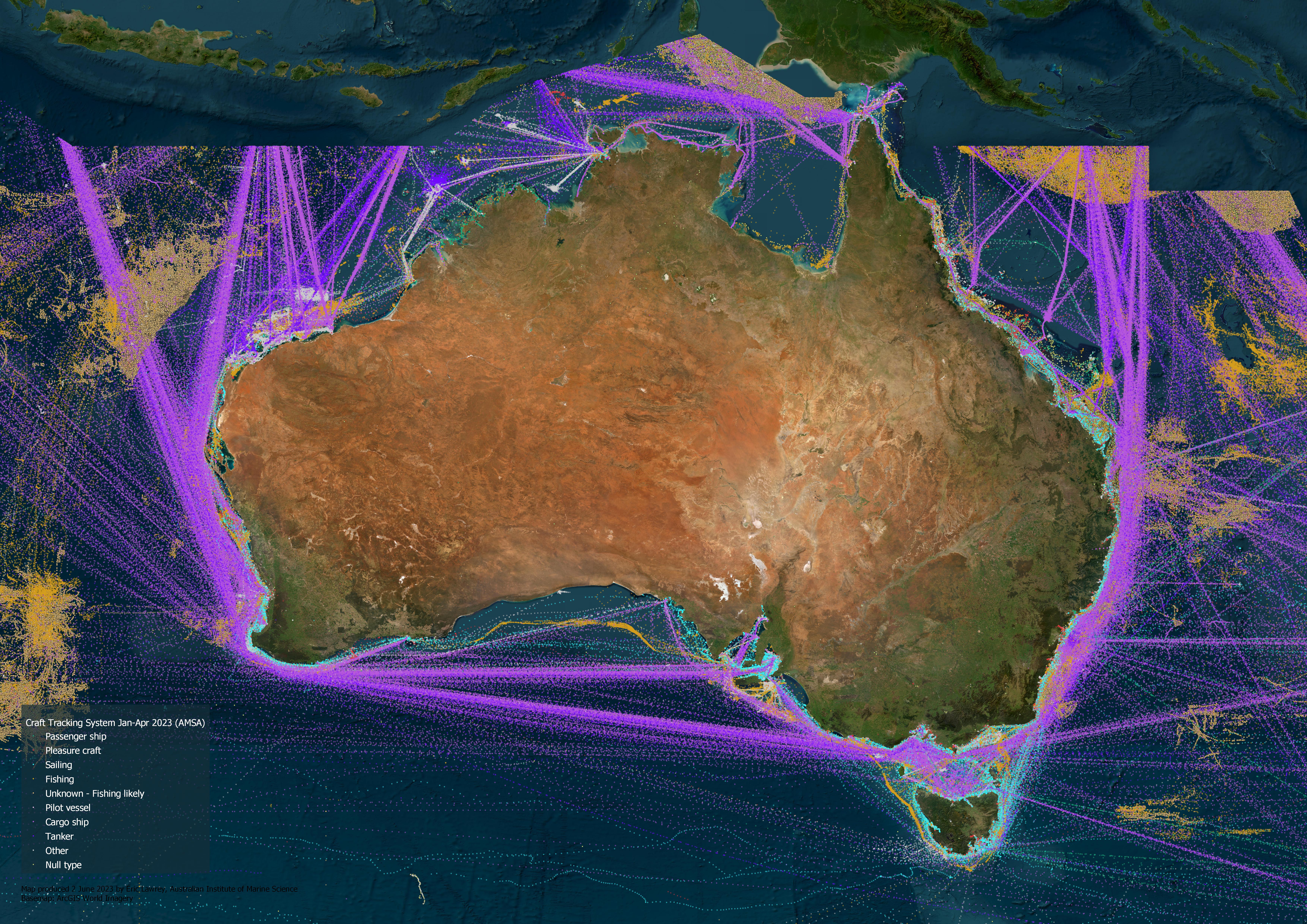
This dataset is an extract and collation of 4 months of data from the Craft Tracking System run by the Australian Maritime Safety Authority (AMSA). This dataset shows the location of cargo ships, fishing vessels, passenger ships, pilot vessels, sailing boats, tankers and other vessel types at 1 hour intervals. The Craft Tracking System (CTS) and Mariweb are AMSA’s vessel traffic databases. They collect vessel traffic data from a variety of sources, including terrestrial and satellite shipborne Automatic Identification System (AIS) data sources. This dataset has been built from AIS data extracted from CTS, and it contains vessel traffic data for January - April 2023. The dataset covers the extents of Australia’s Search and Rescue Region. Each point within the dataset represents a vessel position report and is spatially and temporally defined by geographic coordinates and a Universal Time Coordinate (UTC) timestamp respectively. This dataset is a derivative of the monthly Craft Tracking System data available from https://www.operations.amsa.gov.au/Spatial/DataServices/DigitalData. As such this record is not authoritative about the source data. If you have any queries about the Craft Tracking System data please contact AMSA. Description of the data: This data shows a high volume of cargo ships and tankers traveling between international destinations and the ports of Australia, as well as significant cargo traffic between domestic ports. These vessels tend to travel in straight lines along designated shipping lanes, or along paths that maximize their efficiency on route to their destination. Fishing activities are prominent in international waters, particularly in the Indian Ocean, Coral Sea, and Arafura Seas. The tracking of fishing vessels drops dramatically at the boundary of the Australian Exclusive Economic Zone (EEZ). Most domestic fishing activities appear to be closer to the Australian coast, often concentrating on the edge of the continental shelf. However, the data does not specifically indicate whether the vessels are domestic or international. Western Australia exhibits a great deal of vessel activity associated with the oil and gas industry. Each of these platforms is serviced by tugboats and tankers. At large ports, dozens of cargo ships wait in grid patterns to transit into the port. Shipping traffic in most of the Gulf of Carpentaria is relatively sparse, as the majority of cargo vessels travel from Torres Strait west into the Arafura Sea, bypassing the gulf. However, there is a noticeable concentration of fishing activity along the coast around Karumba and the Wellesley Islands, presumably associated with the prawning industry. Along the Queensland coastline, vessel traffic is dominated by cargo ships, which travel in designated shipping areas between the Great Barrier Reef and the mainland. There are three passages through the reef off Hay Point (Hydrographers Passage), north of Townsville (Palm Passage), and off Cairns (Grafton Passage). The Great Barrier Reef (GBR) region is frequented by pleasure crafts, sailing vessels, and passenger ships. Pleasure crafts mainly seem to visit the islands and outer reefs, while sailing vessels tend to stay within the GBR lagoon, traversing its length. Passenger ships ferry people to popular reef destinations such as reefs off the Whitsundays, Cairns, and Port Douglas, as well as Heron Island and Lady Musgrave Island. Many large passenger ships, presumably cruise vessels, travel between major ports and international destinations. These ships tend to travel 20 km further offshore than the majority of sailing boats. eAtlas Processing: The following is the processing that was applied to create this derivative dataset. This processing was functionally just a collation of 4 months of data, and a file format change (to GeoPackage) and a trimming of the length of the text attributes (which should not affect their values). Four months of data was used as this was the maximum practical limit of the rendering performance of QGIS and GeoServer. 1. The monthly CTS data was downloaded from https://www.operations.amsa.gov.au/Spatial/DataServices/DigitalData and unzipped. This data was then loaded into QGIS. 2. The `Vector / Data Management Tools / Merge Vector Layers...` tool was used to combine the 4 months of data: Input layers: cts_srr_04_2023_pt, cts_srr_03_2023_pt, cts_srr_02_2023_pt, cts_srr_01_2023_pt Save to GeoPackage: AU_AMSA_Craft-tracking-system_Jan-Apr-2023 Layername: AU_AMSA_Craft-tracking-system_Jan-Apr-2023 3. To reduce the size of the dataset the text attributes were trimmed to the length needed to store the attribute data. `Processing Toolbox > Vector table > Refactor fields` Input layer: AU_AMSA_Craft-tracking-sytem_Jan-Apr-2023 Remove attributes: layer, path (these were created by the Merge Vector Layers tool) Change: Source Expression, Original Length, New Length TYPE, 254, 80 SUBTYPE, 254, 20 TIMESTAMP, 50, 25 Refactored: AU_AMSA_Craft-tracking-system_Jan-Apr-2023_Trim.gpkg Layer name: au_amsa_craft_tracking_system_jan_apr_2023 Data dictionary: - CRAFT_ID: Double Unique identifier for each vessel - LON: Double Longitude in decimal degrees - LAT: Double Latitude in decimal degrees - COURSE: Double Course over ground in decimal degrees - SPEED: Double Speed over ground in knots - TYPE: Text Vessel type NULL 'Cargo ship - All' 'Cargo ship - Carrying DG, HS, or MP, IMO Hazard or pollutant category A' 'Cargo ship - Carrying DG, HS, or MP, IMO Hazard or pollutant category B' 'Cargo ship - Carrying DG, HS, or MP, IMO Hazard or pollutant category C' 'Cargo ship - Carrying DG, HS, or MP, IMO Hazard or pollutant category D' 'Cargo ship - No additional info' 'Cargo ship - Reserved 5' 'Cargo ship - Reserved 6' 'Cargo ship - Reserved 7' 'Cargo ship - Reserved 8' 'Engaged in diving operations' 'Engaged in dredging or underwater operations' 'Engaged in military operations' 'Fishing' 'HSC - All' 'HSC - No additional info' 'HSC - Reserved 7' 'Law enforcement' 'Local 56' 'Local 57' 'Medical transport' 'Other - All' 'Other - Carrying DG, HS, or MP, IMO Hazard or pollutant category A' 'Other - Carrying DG, HS, or MP, IMO Hazard or pollutant category B' 'Other - Carrying DG, HS, or MP, IMO Hazard or pollutant category C' 'Other - No additional info' 'Other - Reserved 5' 'Other - Reserved 6' 'Other - Reserved 7' 'Other - Reserved 8' 'Passenger ship - All' 'Passenger ship - Carrying DG, HS, or MP, IMO Hazard or pollutant category A' 'Passenger ship - Carrying DG, HS, or MP, IMO Hazard or pollutant category B' 'Passenger ship - Carrying DG, HS, or MP, IMO Hazard or pollutant category C' 'Passenger ship - Carrying DG, HS, or MP, IMO Hazard or pollutant category D' 'Passenger ship - No additional info' 'Passenger ship - Reserved 5' 'Passenger ship - Reserved 6' 'Passenger ship - Reserved 7' 'Pilot vessel' 'Pleasure craft' 'Port tender' 'Reserved' 'Reserved - All' 'Reserved - Carrying DG, HS, or MP, IMO Hazard or pollutant category B' 'Reserved - Carrying DG, HS, or MP, IMO Hazard or pollutant category C' 'Reserved - Reserved 6' 'Reserved - Reserved 7' 'Sailing' 'SAR' 'Ship according to RR Resolution No. 18 (Mob-83)' 'Tanker - All' 'Tanker - Carrying DG, HS, or MP, IMO Hazard or pollutant category A' 'Tanker - Carrying DG, HS, or MP, IMO Hazard or pollutant category B' 'Tanker - Carrying DG, HS, or MP, IMO Hazard or pollutant category C' 'Tanker - Carrying DG, HS, or MP, IMO Hazard or pollutant category D' 'Tanker - No additional info' 'Tanker - Reserved 5' 'Tanker - Reserved 6' 'Tanker - Reserved 7' 'Tanker - Reserved 8' 'Towing' 'Towing Long/Large' 'Tug' 'unknown code 0' 'unknown code 1' 'unknown code 100' 'unknown code 104' 'unknown code 106' 'unknown code 111' 'unknown code 117' 'unknown code 123' 'unknown code 125' 'unknown code 140' 'unknown code 150' 'unknown code 158' 'unknown code 2' 'unknown code 200' 'unknown code 207' 'unknown code 209' 'unknown code 223''unknown code 230' 'unknown code 253' 'unknown code 255' 'unknown code 4' 'unknown code 5' 'unknown code 6''unknown code 9' 'Vessel with anti-pollution facilities or equipment' 'WIG - All' 'WIG - Carrying DG, HS, or MP, IMO Hazard or pollutant category A' 'WIG - Carrying DG, HS, or MP, IMO Hazard or pollutant category B' 'WIG - Carrying DG, HS, or MP, IMO Hazard or pollutant category C' 'WIG - No additional info' 'WIG - Reserved 6' 'WIG - Reserved 7' - SUBTYPE: Text Vessel sub-type NULL 'Fishing Vessel' 'Powerboat' - LENGTH: Short integer Vessel length in metres - BEAM: Short integer Vessel beam in metres - DRAUGHT: Double Draught of the vessel, in metres. - TIMESTAMP: Text Vessel position report UTC timestamp in dd/mm/yyyy hh:mm:ss AM/PM format eAtlas notes: Fishing vessels are encoded as, TYPE: Fishing or TYPE: NULL, SUBTYPE: Fishing Vessel or TYPE: unknown code X. A lot of the vessels with and unknown code appeared to be predominately fishing vessels based on their behaviour. Location of the data: This dataset is filed in the eAtlas enduring data repository at: data\\non-custodian\ongoing\AU_AMSA_Craft-tracking-system