
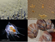
Recent datasets
This dataset shows the effects of of the insecticide imidacloprid and the fungicide propiconazole on larval development of the acorn barnacle Amphibalanus amphitrite experiments conducted in 2018 and 2019.
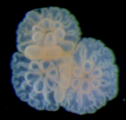
This dataset shows the effects of hexazinone (detected in the Great Barrier Reef catchments) on growth (as bell surface area), photosynthesis (effective quantum yield), zooxanthellae density (cells mm-2) and statolith number on the upside-down jellyfish Cassiopea maremetens during laboratory experiments conducted in 2017.
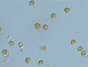
This dataset shows the effects of imazapic (detected in the Great Barrier Reef catchments) on the growth rate (from cell density data) on the cyanobacteria Microcystis aeruginosa over a 72 hour exposure period during laboratory experiments conducted in 2019.
This dataset contains benthic photosynthetically active radiation (PAR; bPAR) at the Q-IMOS Myrmidon, Palm Passage and Heron Island South mooring stations from May 2016 through to November 2017.
This dataset shows the effects of three insecticides (diazinon, fipronil, imidacloprid) and two fungicides (chlorothalonil, propiconazole) on larval metamorphosis in the coral Acropora tenuis. These five pesticides have been detected in the Great Barrier Reef lagoon and/or catchments. Settlement assays were conducted in Nov-Dec 2016 and Nov 2017.
This dataset shows the effects of herbicides (detected in the Great Barrier Reef catchments) on the growth rates (from cell density data) and photosynthesis (effective quantum yield) on the free-living form of the dinoflagellate coral symbiont Cladocopium goreaui during laboratory experiments conducted from 2017-2019.
This dataset summarises daily integrals of photosynthetically active radiation (PAR) at six sites in Cleveland Bay from March 2017 to October 2018. PAR was measured every 15 minutes (as µmol m-2 s-1), and converted to daily light integrals (mol m-2 d-1).
This dataset provides the results of U-Th dating of coral samples obtained from reef matrix percussion cores and death assemblages from Mazie Bay, North Keppel Island, Southern Great Barrier Reef. Data is presented for 117 coral samples ranging in age from 6900 years before present (yr.BP) to modern.
This generated data set contains basic statistical products derived from the eReefs CSIRO hydrodynamic model v2.0 (https://research.csiro.au/ereefs) outputs at both 1km and 4km resolution, generated by the AIMS eReefs Platform (https://ereefs.aims.gov.au/ereefs-aims).
This generated data set contains exposure products derived from the eReefs CSIRO hydrodynamic model v2.0 (https://research.csiro.au/ereefs) outputs at both 1km and 4km resolution, generated by the AIMS eReefs Platform (https://ereefs.aims.gov.au/ereefs-aims).
The eAtlas delivers its NetCDF (Network Common Data Form) data file using a THREDDS Data Server (TDS), which provides metadata and data access using OPeNDAP, OGC WMS and WCS, HTTP, and other remote data access protocols.
The eAtlas delivers its mapping products via two Web Mapping Services, a legacy server (from 2008-2011) and a newer primary server (2011+) to which all new content is added. This record describes the primary WMS.
This generated data set contains summaries (daily, monthly, annual) of the eReefs CSIRO biogeochemistry model v3.1 (https://research.csiro.au/ereefs) outputs at 4km resolution, generated by the AIMS eReefs Platform (https://ereefs.aims.gov.au/ereefs-aims).
This generated data set contains summaries (daily, monthly, annual) of the eReefs CSIRO hydrodynamic model v2.0 (https://research.csiro.au/ereefs) outputs at both 1km and 4km resolution, generated by the AIMS eReefs Platform (https://ereefs.aims.gov.au/ereefs-aims).
This dataset shows the tiling grid and their IDs for Sentinel 2 satellite imagery. The tiling grid IDs are useful for selecting imagery of an area of interest.
Sentinel 2 is an Earth observation satellite developed and operated by the European Space Agency (ESA). Its imagery has 13 bands in the visible, near infrared and short wave infrared part of the spectrum. It has a spatial resolution of 10 m, 20 m and 60 m depending on the spectral band.
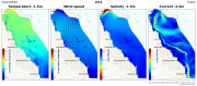
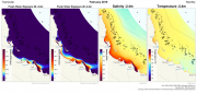
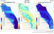
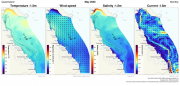
This data set contains summaries (daily, monthly, seasonal, annual) of the eReefs CSIRO hydrodynamic model outputs (GBR 4km v2.0 and GBR 1km v 2.0), covering water temperature, salinity and current at 6 depths (GBR1: 1.5m, 18m, 49m, 103m, 200m and 315m, GBR4: 2.35m, 18m, 49m, 103m, 200m and 315m). These summaries are aggregates derived from the original hourly model data made available via the National Computing Infrastructure (NCI).
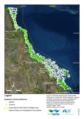
This dataset summarises 30 years of seagrass data collection (1984-2014) within the Great Barrier Reef World Heritage Area. The Site data describes seagrass at 66,210 sites; while the Meadow data describes seagrass at 1,169 individual or composite meadows. The data includes information on species, meadow type and age and reliability of the data. The dataset is available as shapefiles, GIS layer packages, and/or a CSV file. Data represented in this dataset has been collected by the TropWATER Seagrass Group and CSIRO in a GIS database.
This dataset consists of a review of case studies and descriptions of coral restoration methods from four sources:
1) the primary literature (i.e. published peer-reviewed scientific literature),
2) grey literature (e.g. scientific reports and technical summaries from experts in the field),
3) online descriptions (e.g. blogs and online videos describing projects), and
4) an online survey targeting restoration practitioners (doi:10.5061/dryad.p6r3816).
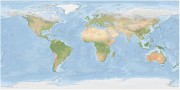
The Bright Earth eAtlas Basemap dataset collection is a satellite-derived global map of the world at a 1:1M scale for most of the world and 1:200k scale for Australia. This map was inspired by Natural Earth II (NEII) and NASA's Blue Marble Next Generation (BMNG) imagery.
Its aim was to provide a basemap similar to NEII but with a higher resolution (~10x).
This dataset shows the effects of eight herbicides (detected in Great Barrier Reef catchments) on the specific growth rates (from cell density data) of the microalgae Tetraselmis sp. during laboratory experiments conducted in 2019.