 eAtlas Data Catalogue
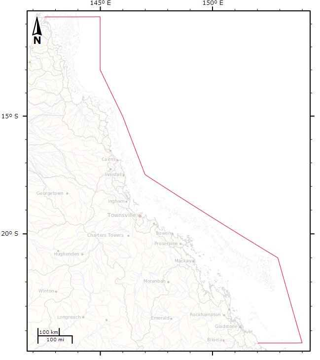
Great Barrier Reef Marine Park Boundary - Ocean Bounds (NERP TE 13.1 eAtlas, source:GBRMPA)
This dataset shows the ocean side boundary of the Great Barrier Reef Marine Park, excluding the inner boundary along the Queensland coastline.
This dataset was derived from the Great Barrier Reef Marine Park Boundary dataset by loading the GBRMPA_BOUNDS_Line.shp (supplied by GBRMPA) into ArcMap then deleting the verticies along the coastline, breaking the original closed line loop.
This dataset is not authorive and was produced for use in the eAtlas. Contact the Spatial Data Centre at GBRMPA for the official boundaries.
Simple
Identification info
- Alternate title
- GBR_e-Atlas-GBRMPA_GBRMP-bounds_Ocean-bounds
- Alternate title
- GBR_e-Atlas-GBRMPA_GBRMP-bounds_Ocean-bounds.shp
- Date (Creation)
- 2011-11-10T00:00:00
- Date (Publication)
- 2013-04-26T00:00:00
- Date (Revision)
- 2011-11-10T00:00:00
- Purpose
- This dataset was created for the eAtlas for creating a base map of the Great Barrier Reef region similar to that used in the GBRMPA Outlook 2009 report. Please contact GBRMPA for more information on the official boundaries.
- Status
- Completed
Point of contact
Lawrey, Eric, DrAustralian Institute of Marine Science (AIMS)
PRIVATE MAIL BAG 3, TOWNSVILLE MAIL CENTRE
Townsville
Queensland
4810
Australia
- Spatial representation type
- Vector
- Topic category
-
- Boundaries
- Oceans
Extent
Extent
N
S
E
W
))
Extent
Extent
- Geographic identifier
-
GREAT BARRIER REEF
- Title
- ANZLIC Geographic Extent Name Register
- Date (Publication)
- 2006-10-10T00:00:00
- Edition
- Version 2
- Edition date
- 2001-02-01T00:00:00
- Citation identifier
- http://anzlicmet.bluenet.utas.edu.au/anzmetlite/mcp-allgens.xml#GREAT BARRIER REEF
Resource format
- Title
- ESRI shapefile
- Date
- Edition
- 9.x
Resource format
- Title
- KMZ
- Date
- Edition
- 1
- GCMD Science Keywords 5.3.8
-
- Human Dimensions | Boundaries | Administrative Divisions
- Oceans | Marine Environment Monitoring
- Keywords (Theme)
-
- marine
Resource constraints
- Use limitation
- © eAtlas, Australian Institute of Marine Science, © Commonwealth of Australia (Great Barrier Reef Marine Park Authority) This GBR_e-Atlas-GBRMPA_GBRMP-bounds_Ocean-bounds.shp incorporates Data which is © Commonwealth of Australia (Great Barrier Reef Marine Park Authority) [2009]. The data has been used in GBR_e-Atlas-GBRMPA_GBRMP-bounds_Ocean-bounds.shp with permission of the Commonwealth. The Commonwealth has not evaluated to Data as altered and incorporated within GBR_e-Atlas-GBRMPA_GBRMP-bounds_Ocean-bounds.shp, and therefore gives no warranty regarding its accuracy, completeness, currency or suitability for any particular purpose.
- Use constraints
- Copyright
Resource constraints
- Use limitation
- For up to date licensing information please refer to: http://www.gbrmpa.gov.au/resources-and-publications/spatial-data-information-services/licensing-and-copyright-information. This dataset was developed for display purposes and is not available for general download. Access to this dataset is limited and bound by the original license aggrement provided by GBRMPA.
- Use constraints
- License
- Language
- English
- Character encoding
- UTF8
Distribution Information
Distributor
- Title
- ESRI shapefile
- Date
- Edition
- 9.x
- OnLine resource
- ea:GBR_e-Atlas-GBRMPA_GBRMP-bounds_Ocean-bounds
- OnLine resource
- eAtlas Web Mapping Service (WMS) (AIMS)
- OnLine resource
- eAtlas project page
Resource lineage
- Statement
- This dataset was derived from the GBRMPA_BOUNDS_Line.shp dataset, owned by the Great Barrier Reef Marine Park Authority. A copy of the GBRMPA_BOUNDS_Line.shp was loaded into ArcMap then edited. The verticies along the coastline were deleted and the closed line loop was broken.
- Hierarchy level
- Dataset
- Other
- dataset
Reference System Information
- Reference system identifier
- GDA94
Metadata
- Metadata identifier
- urn:uuid/2987b7c3-c575-499c-a896-c17c46da0c39
- Language
- English
- Character encoding
- UTF8
Point of contact
eAtlas Data ManagerAustralian Institute of Marine Science (AIMS)
PRIVATE MAIL BAG 3, TOWNSVILLE MAIL CENTRE
Townsville
Queensland
4810
Australia
- Parent metadata
Type of resource
- Resource scope
- Dataset
- Name
- dataset
- Metadata linkage
-
https://eatlas.org.au/data/uuid/2987b7c3-c575-499c-a896-c17c46da0c39
Point of truth URL of this metadata record
- Date info (Creation)
- 2016-03-03T12:08:05
- Date info (Revision)
- 2024-02-01T11:01:19
Metadata standard
- Title
- ISO 19115-3:2018
Overviews
large_thumbnail
Spatial extent
N
S
E
W
Provided by

Associated resources
Not available