 eAtlas Data Catalogue
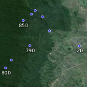
Spot heights for the Wet Tropics Bioregion (WTMA)
This dataset contains point features depicting spot heights for the Wet Tropics Bioregion.
The SpotHeight-250K dataset was sourced primarily from the 1:250 000 scale National Topographic Map Series (NTMS) and the Royal Australian Survey Corps Joint Operation Graphics (JOG) map reproduction material (repromat).
This dataset consists of a 25 MB shapefile containing 134,007 point features.
*Accuracy*
Horizontal accuracy is at 90% of well-defined detail within +/- 125m of true position. The dataset has an attribute accuracy of 100%.
Data reproduced with permission of Wet Tropics Management Authority
This metadata was prepared for the eAtlas and is not authoritative. Please contact the Wet Tropics Management Authority for an authoritative record.
Simple
Identification info
- Date (Publication)
- 2013-12-01T10:43:00
- Status
- Completed
- Topic category
-
- Biota
Extent
Extent
))
Resource constraints
- Use limitation
- Wet Tropics Management Authority
- Use constraints
- Copyright
Resource constraints
- Use limitation
- This dataset was made available to the eAtlas from WTMA under a restrictive non-commercial license. This license has restrictions to: a) not make the data available to a third party by sale or otherwise; and b) not sell products derived from the data; and c) not use the data to cause substantial distortion to normal competitive arrangements; and d) not use the data to derive income or gain a financial return. The full license is stored with the datasets. Base data/Data reproduced with permission of Wet Tropics Management Authority.
- Use constraints
- License
Resource constraints
- Use limitation
- Full citation: Wet Tropics Management Authority (2013). Spot heights for the Wet Tropics Bioregion of Queensland. Wet Tropics Management Authority, Cairns. https://eatlas.org.au/data/uuid/432926ac-7e50-4498-81f1-1db83569f9d6
- Language
- English
- Character encoding
- UTF8
Distribution Information
- Distribution format
-
- ESRI Shapefile
- OnLine resource
- wtma:WT_WTMA_SpotHeight-250k
- OnLine resource
- wtma:WT_WTMA_SpotHeight-250k_Med
- OnLine resource
- Interactive map of this dataset
- OnLine resource
- Preparation of the spot height data for the eAtlas [PDF, 275 kB]
- OnLine resource
- eAtlas Web Mapping Service (WMS) (AIMS)
Reference System Information
- Reference system identifier
- EPSG/EPSG:28355
Metadata
- Metadata identifier
- 432926ac-7e50-4498-81f1-1db83569f9d6
- Language
- English
- Character encoding
- UTF8
Point of contact
Lawrey, Eric, Dr.Australian Institute of Marine Science (AIMS)
Type of resource
- Resource scope
- Dataset
- Metadata linkage
-
https://eatlas.org.au/data/uuid/432926ac-7e50-4498-81f1-1db83569f9d6
Point of truth URL of this metadata record
- Date info (Creation)
- 2018-08-20T02:04:28
- Date info (Revision)
- 2018-08-20T02:04:28
Metadata standard
- Title
- ISO 19115-3:2018
Overviews

Spatial extent
Provided by
