 eAtlas Data Catalogue
eAtlas World Baselayer Version 1 (NERP TE 13.1, AIMS)
The eAtlas baselayer is a collection of datasets from third parties styled and combined together to produce a world wide map layer with reasonable detail across the Great Barrier Reef suitable as a baselayer in web mapping applications.
The primary basis for this baselayer is the Natural Earth 2 public domain raster map of the world. Overlaid on this is country outlines, cities and Great Barrier Reefs.
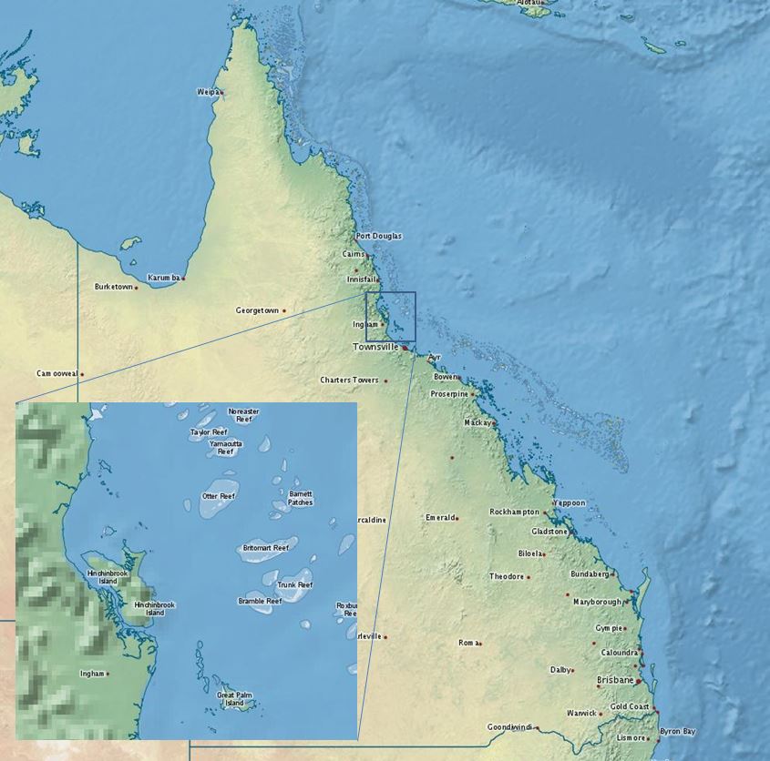
It has a focus on Australia and the Great Barrier Reef and includes a high resolution coast for Australia (100k) and an even high resolution coast for Queensland (50k).
The baselayer has three levels of nested detail. It starts with the world view datasets (Natural Earth 2 & 10m countries) combined with a high resolution Australian coastline (Coast 100k) combined with a still higher resolution Queensland coastline (GBR features). In addition to this the GBR features combined with the GBR dry reefs provides detailed outlines for reefs within the Great Barrier Reef Marine Park.
This nesting is achieved by using a layer group in GeoServer to sandwich all 6 layers together into one map. The styling of the 10m countries layer is done so that all countries except Australia are rendered, leaving a hole for the high resolution Australian coastline. The Coast100k it is styled so that all states are shown except Queensland; again to leave a hole for a higher resolution Queensland coastline. To get the Queensland coastline the GBR features mainland is used.
Format:
This dataset collection is organised as files in a structure the same as the configuration of GeoServer version 2.1 - 2.3. This allows it to be easily deployed as a web map service. The files can simply be pasted into the GeoServer directory. The data, along with the configuration and styling will be installed. This quick install procedure has been tested on version 2.1.0, 2.2.4 and 2.3 of GeoServer. More recent version may require manual editing deploy the data.
The size of this dataset is 260 MB.
Note:
This dataset has been superseded by the higher resolution Bright Earth eAtlas Basemap (NERP TE 13.1 eAtlas, AIMS) dataset.
Data Location:
This dataset is filed in the eAtlas enduring data repository at: data\NERP-TE\13.1_eAtlas\World_NERP-13-1_eAtlas_Basemap_v1-2013
Simple
Identification info
- Date (Publication)
- 2013-02-25T12:52:00
- Edition
- 1.0
- Edition date
- 2013-02-25T00:00:00
Principal investigator
Lawrey, Eric, DrAustralian Institute of Marine Science (AIMS)
- Purpose
- This dataset was developed as a baselayer for the eAtlas web mapping portal
- Status
- Completed
- Spatial representation type
- Grid
Spatial resolution
- Spatial resolution
- 2
- Topic category
-
- Oceans
Extent
Extent
))
- Keywords (Theme)
-
- Land Surface | Topography | Landforms
- marine
Resource constraints
- Use limitation
- The following are the license details of the datasets contained in this baselayer: World_NED_NE2 (Natural Earth 2), World_NED_10m-countries, World_NED_10m-cities These datasets are public domain, released and maintained by www.naturalearthdata.com. GBR_GBRMPA_GBR-dry-reef, GBR_GBRMPA_GBR-features: © Great Barrier Reef Marine Park Authority 2014. Updated data available at http://www.gbrmpa.gov.au/geoportal/. It is available under a Creative Commons Attribution 4.0 International Licence AU_GA_Coast100k-2004: This dataset was downloaded from the Geoscience Australia website (Sept 2010) from: http://www.ga.gov.au/metadata-gateway/metadata/record/gcat_61395. It is available under a Creative Commons Attribution 4.0 International Licence
- Access constraints
- License
Resource constraints
- Use limitation
- Short form: <a href="https://eatlas.org.au/data/uuid/869d75cf-3a06-4154-8705-2b7f782827d8">eAtlas World Baselayer v1.0</a> (AIMS, Natural Earth, GBRMPA, GA) Short form printed form: eAtlas World Baselayer v1.0 (AIMS, https://eatlas.org.au/data/uuid/869d75cf-3a06-4154-8705-2b7f782827d8) based on data supplied by Natural Earth, Commonwealth of Australia (Great Barrier Reef Marine Park Authority) and Geoscience Australia.
- Access constraints
- Copyright
Resource constraints
- Linkage
-
http://i.creativecommons.org/l/by/3.0/au/88x31.png
License Graphic
- Title
- Creative Commons Attribution 3.0 Australia License
- Website
-
http://creativecommons.org/licenses/by/3.0/au/
License Text
- Language
- English
- Character encoding
- UTF8
Distribution Information
- Distribution format
-
-
GeoTiff, Shapefile, SLDs, GeoServer configuration
- File decompression technique
- zip
-
GeoTiff, Shapefile, SLDs, GeoServer configuration
- OnLine resource
- eAtlas Web Mapping Service (WMS) (AIMS)
- OnLine resource
- Interactive map of this dataset
- OnLine resource
- World_NE2-coast-cities-reefs_Baselayer
Resource lineage
- Statement
- Since the basic raster baselayer comes from Natural Earth 2 it only has a resolution of 2 km which is considerably lower resolution than the GBR coastline. This leads to some areas of rastered coastline not matching the vector coastline very well when zoomed in. This sandwiching of the features gives a good level of detail to the Queensland coastline without too much complication, however there are some minor problems. The GBR features dataset does not line up exactly with the Northern Terriorty state boundary leaving a small gap between the states. In addition to this the GBR features is not particularly detailed on the west coast of Cape York.
Metadata
- Metadata identifier
- urn:uuid/869d75cf-3a06-4154-8705-2b7f782827d8
- Language
- English
- Character encoding
- UTF8
Point of contact
eAtlas Data ManagerAustralian Institute of Marine Science (AIMS)
- Parent metadata
Type of resource
- Resource scope
- Dataset
- Metadata linkage
-
https://eatlas.org.au/data/uuid/869d75cf-3a06-4154-8705-2b7f782827d8
Point of truth URL of this metadata record
- Date info (Creation)
- 2016-08-02T14:48:54
- Date info (Revision)
- 2023-09-18T08:26:56
Metadata standard
- Title
- ISO 19115-3:2018
Overviews
Spatial extent
Provided by
