 eAtlas Data Catalogue
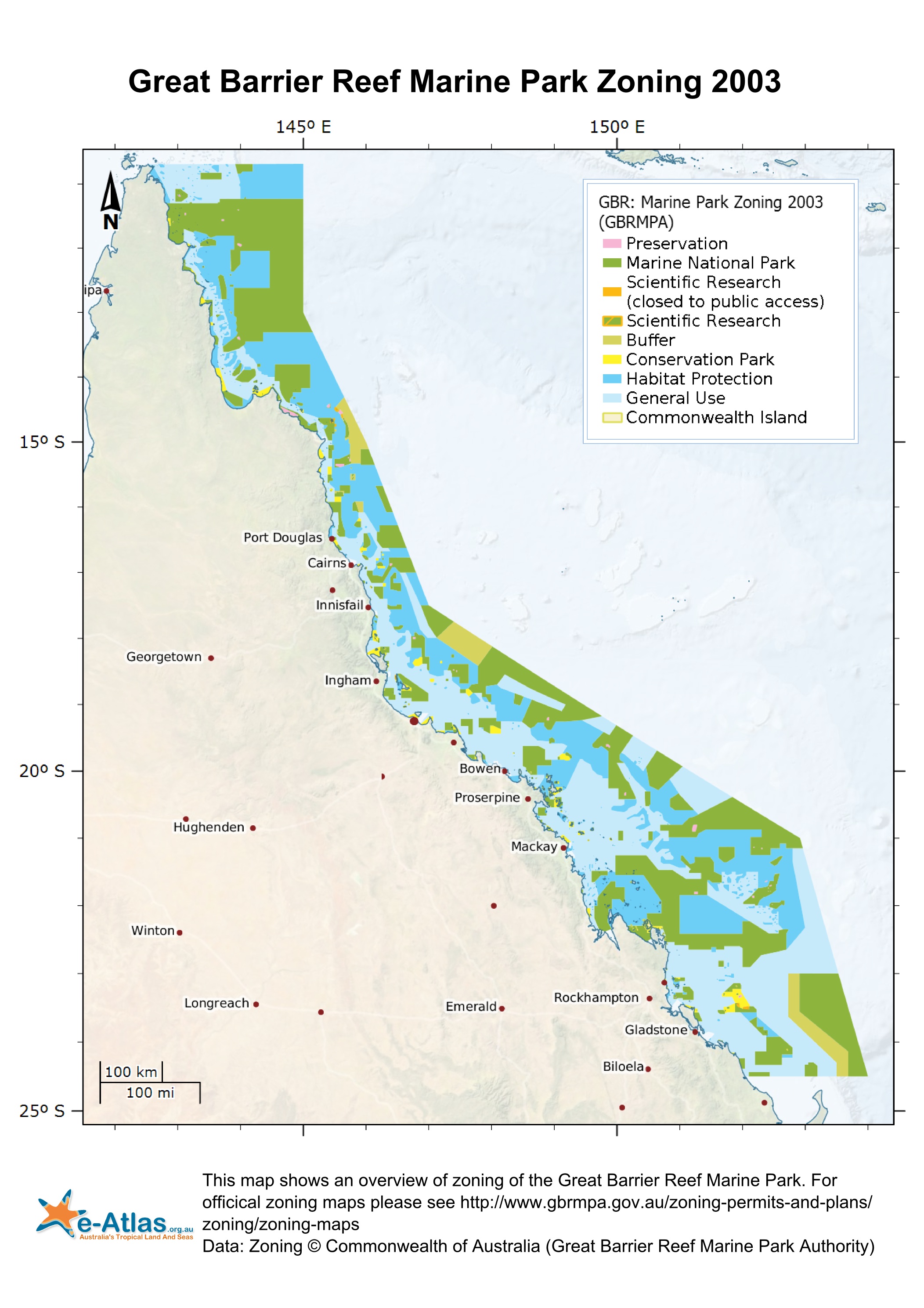
Great Barrier Reef Marine Park Zoning 2003 (GBRMPA)
This dataset corresponds to the zoning within the Great Barrier Reef Marine Park effective 1st July 2004. It is derived from the Great Barrier Reef Marine Park Zoning Plan 2003.
The Great Barrier Reef Marine Park is a multiple-use area. Zoning helps to manage and protect the values of the Marine Park that users enjoy. Zoning Plans define what activities occur in which locations both to protect the marine environment and to separate potentially conflicting activities. Revised zoning of the Great Barrier Reef Marine Park was introduced in July 2004 as part of the Great Barrier Reef Marine Park Authority's Representative Areas Programme.
Between 1999 and 2004, the Great Barrier Reef Marine Park Authority undertook a systematic planning and consultative program to develop new zoning for the Marine Park. The primary aim of the program was to better protect the range of biodiversity in the Great Barrier Reef, by increasing the extent of no-take areas (or highly protected areas, locally known as ‘Green Zones’), ensuring they included 'representative' examples of all different habitat types - hence the name, the Representative Areas Program or RAP. Whilst increasing the protection of biodiversity, a further aim was to maximise the benefits and minimise the negative impacts of the rezoning on the existing users of the Marine Park. Both these aims were achieved by a comprehensive program of scientific input, community involvement and innovation [1].
In each zones there are a range of activities that are allowed, disallowed or require a permit. The following outlines a summary of activities that are disallowed in each zone. Please refer to [2] for a more detailed and authoritative description of all restrictions within each zone:
* General Use Zone: General use, some activities require a permit.
* Habitat Protection Zone: No trawling, some activities require permits.
* Conservation Park Zone: No trawling, limited crabbing and line fishing.
* Buffer Zone: No aquaculture, bait netting, crabbing, harvesting fishing, collecting, spearfishing, line fishing, netting and trawling. Trolling for pelagic fish is allowed.
* Scientific Research Zone: Research areas primarily around scientific research facilities. Same as Buffer zone but with no trolling.
* Marine National Park Zone (Green): 'no-take' area. The following are allowed: boating, diving, photography and limited impact research. Some other activities are allowed with permits.
* Preservation Zone (Pink): 'no go' area. No activities are allowed except research activities with a permit.
Official maps derived from this dataset can be downloaded from the GBRMPA Zoning Maps [3] page.
This dataset can now be downloaded directly from GBRMPA's Geoportal.
This metadata was prepared for the eAtlas and is not authoritative. Please contact the Great Barrier Reef Management Authority for an authoritative record.
Data Location:
This dataset is filed in the eAtlas enduring data repository at: data\other\GBR_GBRMPA_Zoning-2003
Simple
Identification info
- Alternate title
- GBR_GBRMPA_Zoning-2003
- Alternate title
- ZONING.shp
- Date (Revision)
- 2008-11-12T00:00:00
- Status
- Completed
- Spatial representation type
- Vector
- Topic category
-
- Boundaries
- Oceans
Extent
Extent
- Description
- Great Barrier Reef Marine Park

Extent
Extent
- GCMD Science Keywords 5.3.8
-
- Human Dimensions | Boundaries | Administrative Divisions
- Oceans | Marine Environment Monitoring
- Keywords (Theme)
-
- marine
Resource constraints
- Linkage
-
http://i.creativecommons.org/l/by/3.0/au/88x31.png
License Graphic
- Title
- Creative Commons Attribution 3.0 Australia License
- Website
-
http://creativecommons.org/licenses/by/3.0/au/
License Text
- Other constraints
- This material is licensed under a Creative Commons - Attribution 4.0 International licence. Great Barrier Reeef Marine Park Authority requests attribution in the following manner: © Great Barrier Reef Marine Park Authority 2014. Updated data available at http://www.gbrmpa.gov.au/geoportal/.
- Language
- English
- Character encoding
- UTF8
- Supplemental Information
- Attributes: This shapefile contains the Great Barrier Reef Marine Park zoning with attributes corresponding to the Collaborative Australian Protected Areas Database standard. For more information see [4]. - NAME: (Examples: HP-23-5365, MNP-23-1168, CP-23-4109, Acheron Island (18066100), Bramble Rock (19001100)). Official name of the protected area. - IUCN: (IA, II, IV, VI). The IUCN protected area category. - IA: Strict Nature Reserve: protected area managed mainly for science. - II: National Park: protected area managed mainly for ecosystem protection, - IV: Habitat / Species Management Area: protected area managed mainly for conservation through management intervention. - VI: Managed Resource Protected Area: protected area managed mainly for the sustainable use of natural ecosystems - NRS_PA: ???? (Y) - GAZ_AREA: (0 - 3683323). The declared area of a reserve, as opposed to a machine calculated area. It is recorded to the nearest hectare. - GIS_AREA: (0 - 3683323) The spatial area of a reserve (in hectares) calculated by GIS software, derived from Albers Equal Area projection. - RES_NO: (Examples: 101001, 101002, 10321100, 105001, 241173, 99000100). The reserve number used by the controlling authority. - GAZ_DATE: (date '2004-04-21'). Date of the original proclamation - LATEST_GAZ: (date '2004-04-21') The date of the most recent gazetted amendment or verification by the relevant State authority. - STATE: (QLD) The CODE for the State or Terriory of the protected are. - AUTHORITY: (GBRMPA) The authority with administers the Protected Area - ENVIRON: (M) To delineate the components of CAPAD. (M) Marine - CODE: (6, 7, 9, 10, 12, 13, 14, 16, 32, 66) - X_COORD: (142.63029 to 153.41822). Longitude coordinate of polygon centroid in decimal degrees. - Y_COORD: (-24.46754 to -10.69216). Latitude coordinate of polygon centroid in decimal degrees. - ALT_ZONE: (Commonwealth Island Zone, Dark Blue Zone, Green Zone, Light Blue Zone, Olive Green Zone, Orange Zone, Pink Zone, Yellow Zone) - TYPE: (Buffer, Commonwealth Island, Conservation Park, General Use, Habitat Protection, Marine National Park, Preservation, Scientific Research, Scientific Research (closed to public access) - AREA_TYPE: (GBRMP Zoning) - LOC_NAME_S: (Buffer Zone, Commonwealth Island Zone, Conservation Park Zone, General Use Zone, Habitat Protection Zone, Marine National Park Zone, Preservation Zone, Scientific Research Zone - PERMIT_DES: Examples: 'Bowling Green Bay - west', 'Bylund Cay Reef (21-519)', 'Captain Billy Landing', 'Edgell Bank (22-159) and Moresby Bank (22-158)' - GROUP_ID: (BUZ, CIZ, CPZ, GUZ, HPZ, MPZ, PZ, SRZ) - STD_PERMIT: (' ') - SHAPE_Leng: (0.00197015191562 to 30.4633914997) - SHAPE_Area: (2.64677669276E-07 to 3.24954635378)
Distribution Information
Distributor
- Title
- ESRI shapefile
- Date
- Edition
- 9.x
- Units of distribution
- MB
- Transfer size
- 4
- OnLine resource
- Spatial Data Information Services
- OnLine resource
- Official metadata for this dataset
- OnLine resource
- Download this dataset from GBRMPA's Geoportal.
- OnLine resource
- [1] GBRMPA, Overview of the Representative Areas Program
- OnLine resource
- [2] GBRMPA. Interpreting zones
- OnLine resource
- [3] GBRMPA. Zoning Maps
- OnLine resource
- [4] Technical Specifications for the Collaborative Australian Protected Areas Database CAPAD2012
- OnLine resource
- ea:GBR_GBRMPA_Zoning-2003
- OnLine resource
- Interactive map of the GBR Marine Park Zoning 2003
- OnLine resource
- GBRMP Zoning 2003 [Google Earth KMZ, 1.3MB]. This is an unofficial KMZ created by eAtlas team for research only.
- OnLine resource
- eAtlas Web Mapping Service (WMS) (AIMS)
Resource lineage
- Statement
- The new Zoning Plan replaces the following Zoning Plans previously in place within the Marine Park [5]: * Central Section (in operation since October 1987); * Mackay/Capricorn Section (in operation since August 1988); * Cairns Section (in operation since April 1982); * Far Northern Section (in operation since April 1986); and * Gumoo Woojabuddee Section (in operation since December 2002)
Spatial representation info
- Topology level
- Geometry only
- Geometric object type
- Surface
- Geometric object count
- 758
Reference System Information
- Reference system identifier
- GDA94
Metadata constraints
- Linkage
-
http://i.creativecommons.org/l/by/2.5/au/88x31.png
License Graphic
- Title
- Creative Commons Attribution 2.5 Australia License
- Website
-
http://creativecommons.org/licenses/by/2.5/au/
License Text
Metadata
- Metadata identifier
- 92e4a530-6cbc-456b-918d-55d97c610e01
- Language
- English
- Character encoding
- UTF8
Point of contact
Lawrey, Eric, Dr.Australian Institute of Marine Science (AIMS)
Type of resource
- Resource scope
- Dataset
- Name
- series
- Metadata linkage
-
https://eatlas.org.au/data/uuid/92e4a530-6cbc-456b-918d-55d97c610e01
Point of truth URL of this metadata record
- Date info (Creation)
- 2016-07-18T16:37:59
- Date info (Revision)
- 2016-07-18T16:37:59
Metadata standard
- Title
- ISO 19115-3:2018
Overviews
Spatial extent

Provided by
