 eAtlas Data Catalogue
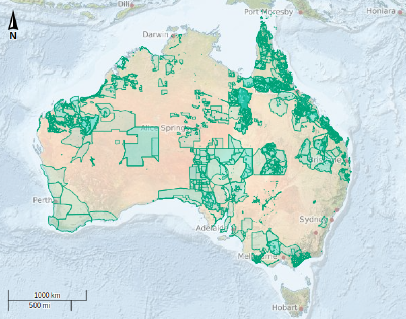
Indigenous Land Use Agreements - November 2020 (NNTT)
An indigenous land use agreement (ILUA) is a voluntary, legally binding agreement about the use and management of land or waters, made between one or more native title groups and non-native title interest holders in the ILUA area (such as grantee parties, pastoralists or governments). The Register of Indigenous Land Use Agreements is kept by the Native Title Registrar in accordance with s 199A of the NTA and includes a description of the ILUA area, the parties' names, the term of the ILUA and other information as the Registrar considers is appropriate (s 199B of the NTA). Registration confers a contractual effect on the ILUA and binds all persons holding native title regardless as to whether they are already parties to the ILUA (s 24EA of the NTA). Note: This dataset contains records of ILUAs that have been publicly notified and/or registered.
Note: This metadata record is a local copy maintained for the eAtlas and is not authoritative. Please see the link to the 'Original metadata record for this dataset' for the full metadata and latest update.
Data Location:
This dataset is filed in the eAtlas enduring data repository at: \\pearl\e-atlas\data\non-custodian\ongoing\AU_NNTT\2023-09-29\original\ILUA_Registered_Notified_Nat.zip
Simple
Identification info
- Date (Publication)
- 2020-11-19
- Purpose
- Geospatial representation of Indigenous Land Use Agreements
- Status
- On going
Point of contact
Geospatial ServicesNational Native Title Tribunal
- Topic category
-
- Boundaries
Extent
Extent
- Description
- Australia
))
Resource constraints
- Use limitation
- Future Act notices boundary data are sourced from the respective organisations issuing the notices. Authorisation is required by those organisations prior to their release. Products using this data should acknowledge the National Native Title Tribunal as the data source.
- Linkage
-
http://i.creativecommons.org/l/by/4.0/88x31.png
License Graphic
- Title
- Creative Commons Attribution 4.0 International License
- Website
-
http://creativecommons.org/licenses/by/4.0/
License Text
- Language
- English
- Character encoding
- UTF8
Distribution Information
- OnLine resource
- eAtlas Web Mapping Service (WMS) (AIMS)
- OnLine resource
- Indigenous Land Use Agreements - Shapefile [41.66 MB]
- OnLine resource
- Interactive map of this dataset
- OnLine resource
- ref:AU_NNTT_Indigenous-Land-Use-Agreements-Reg_ongoing
- OnLine resource
- Original metadata record for this dataset
Resource lineage
- Statement
- Created by the National Native Title Tribunal in 1998 and continuously updated and maintained.
- Hierarchy level
- Dataset
Metadata constraints
- Linkage
-
http://i.creativecommons.org/l/by/3.0/au/88x31.png
License Graphic
- Title
- Creative Commons Attribution 3.0 Australia License
- Website
-
http://creativecommons.org/licenses/by/3.0/au/
License Text
Metadata
- Metadata identifier
- urn:uuid/ae329faa-9683-4515-91ca-838583ed7c7f
- Language
- English
- Character encoding
- UTF8
Point of contact
eAtlas Data ManagerAustralian Institute of Marine Science (AIMS)
Type of resource
- Resource scope
- Dataset
- Metadata linkage
-
https://eatlas.org.au/data/uuid/ae329faa-9683-4515-91ca-838583ed7c7f
Point of truth URL of this metadata record
- Date info (Creation)
- 2020-11-25T07:52:54
- Date info (Revision)
- 2023-12-14T05:48:43
Metadata standard
- Title
- ISO 19115-3:2018
Overviews
Spatial extent
Provided by
