 eAtlas Data Catalogue
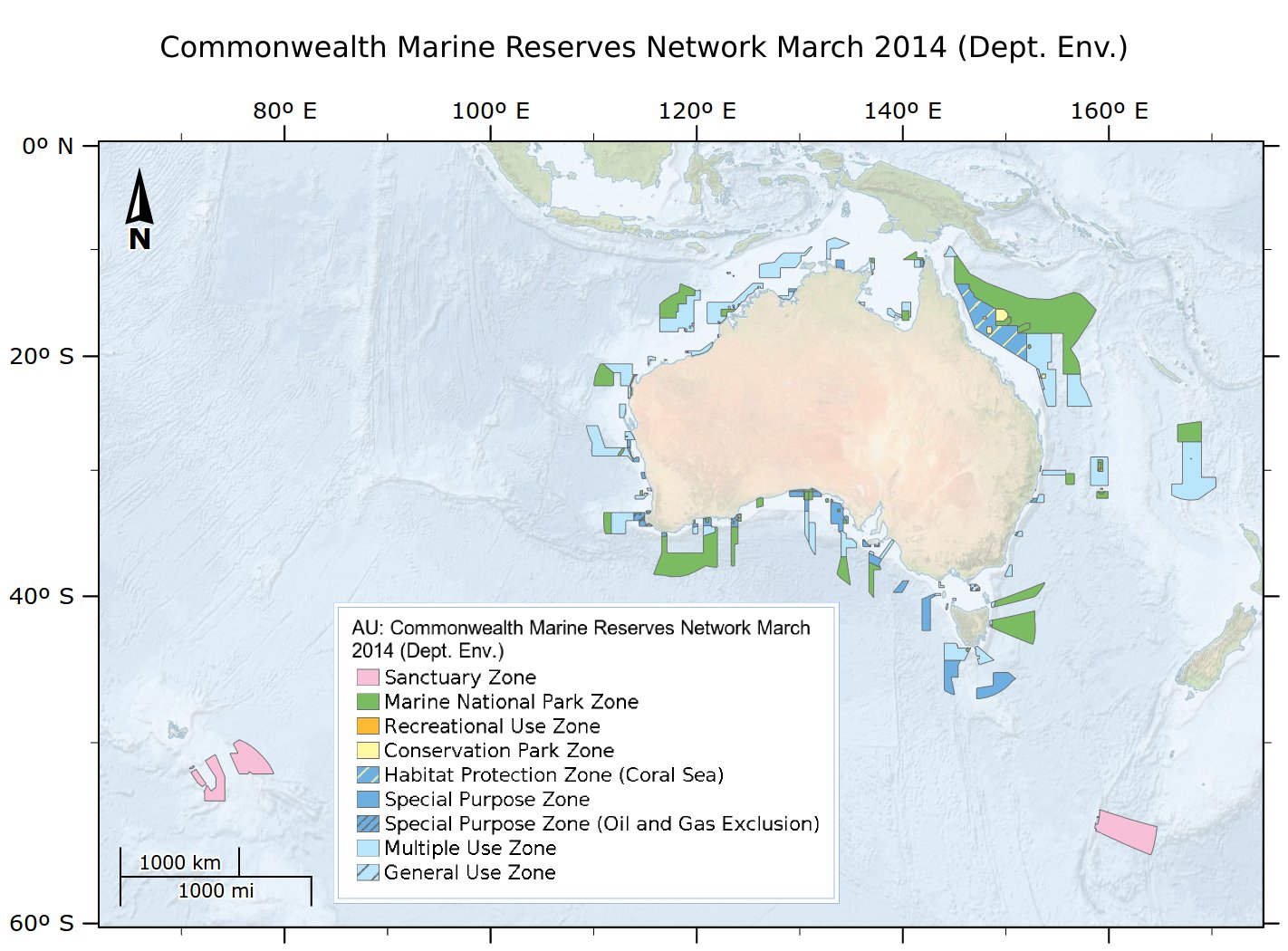
[SUPERSEDED] Australia's network of Commonwealth Marine Reserves 2014 (DCCEEW)
This dataset is not the current marine park zoning. It is retained here for historic purposes. See http://www.environment.gov.au/fed/catalog/search/resource/details.page?uuid=%7BCD8877F3-8C39-4A20-A53F-070FBEE5AF3C%7D for current zoning.
Consistent with the Australian Government's commitment to develop a National Representative System of Marine Protected Areas (MPAs), networks of Commonwealth Marine Reserves have been proclaimed for Commonwealth waters across the South-west, North-west, North, Coral Sea and Temperate East Marine Regions. These networks build on previous Marine Protected Area proclamations, including the South-east network declared in 2007.
This dataset is released under Creative Commons by Attribution-NonCommercial 3.0 Australia (CC BY-NC 3.0).
IMPORTANT INFORMATION FOR MARINE USERS
Transitional arrangements apply to the South-west, North-west, North and Temperate East Networks and the Coral Sea reserve, until management plans come into effect. These arrangements involve NO CHANGES ON THE WATER for marine users. Note, there are no changes to management arrangements in the marine reserves that existed prior to the establishment of the new reserves, that is, the same restrictions on activities will continue to apply even where those reserves have been incorporated into new reserves. The South-east Network of Commonwealth Marine Reserves is managed under the South-east Commonwealth Marine Reserves Network Management Plan 2013-23, in place from 1 July 2013. More information is available at www.environment.gov.au/marinereserves
This data contains spatial and contextual information about Commonwealth Marine Reserves under the jurisdiction of the Commonwealth governments Environment Protection and Biodiversity Conservation Act 1999, which are managed by the Australian Government Department of the Environment. It does not include data on MPA's in other Australian jurisdictions (e.g. the Great Barrier Reef Marine Park, State/Territory parks), or Terrestrial Protected Areas with marine components (eg Pulu Keeling National Park).
This is an extract of the full metadata record supplied by the Department of the Environment with this dataset. See http://www.environment.gov.au/fed/catalog/search/resource/details.page?uuid=%7B0435E716-1798-467C-8F43-E0CB6B32E8EF%7D
for more information.
eAtlas Change Log:
2023-04-04 - Marked the metadata as superseded. Fixed the link to the official data download. Updated the modification date. Changed the copyright from '© Commonwealth of Australia, Australian Government Department of the Environment, 2014' to the current '© Commonwealth of Australia, Australian Government Department of Climate Change, Energy, the Environment and Water, 2014'. Copied over additional lineage. Corrected the licensing from CC BY-NC 2.5 to CC BY-NC 3.0
eAtlas notes:
This dataset is cached in the eAtlas enduring data repository at: data\non-custodian\pre-2015\AU_DotE_Comm-marine-reserves-2014
Simple
Identification info
- Date (Revision)
- 2014-03-28T00:00:00
- Date (Creation)
- 1982-08-16T00:00:00
- Status
- Completed
- Spatial representation type
- Vector
- Topic category
-
- Oceans
Extent
Extent
- Description
- Australian waters
))
Resource constraints
- Linkage
-
http://i.creativecommons.org/l/by-nc/3.0/au/88x31.png
License Graphic
- Title
- Creative Commons Attribution-Noncommercial 3.0 Australia License
- Website
-
http://creativecommons.org/licenses/by-nc/3.0/au/
License Text
- Other constraints
- Australia's network of Commonwealth Marine Reserves. © Commonwealth of Australia, Australian Government Department of Climate Change, Energy, the Environment and Water, 2014
- Language
- English
- Character encoding
- UTF8
Distribution Information
- OnLine resource
- eAtlas Web Mapping Service (WMS) (AIMS)
- OnLine resource
- Official metadata and download of shapefile (ERIN, DIG)
- OnLine resource
- ea:AU_DotE_Comm-marine-reserves-2014
Resource lineage
- Statement
- Australia's network of Commonwealth Marine Reserves have been created in accordance with the Australian Government's 'Goals and Principles for the Establishment of the National Representative System of Marine Protected Areas in Commonwealth Waters'. Boundaries of the areas are based on analysis done by the Department of the Environment of key environmental and socio-economic data. The lines that make up the reserve boundaries were created/sourced from: - parallels and meridians were generated in ArcGIS and then densified to 0.05 decimal degrees (approx. 5km) prior to incorporation with other linework. - intermediate points along geodesic lines (note that, geodesic lines are the shortest line between points, they are not lines of constant bearing) were generated. A maximum segment length of 5km was used, which for this data ensures geodesic lines are within 1 metre of their true position. - maritime boundaries were sourced from AMB 2006 v2.0 (Geoscience Australia). For each MPA, appropriate linework was generated/selected and then intersected to form polygons.
Reference System Information
- Reference system identifier
- EPSG/EPSG:4283
Metadata
- Metadata identifier
- urn:uuid/bda9acbd-960f-415d-8305-09170f9a707f
- Language
- English
- Character encoding
- UTF8
Point of contact
Lawrey, Eric, DrAustralian Institute of Marine Science (AIMS)
Type of resource
- Resource scope
- Dataset
- Metadata linkage
-
https://eatlas.org.au/data/uuid/bda9acbd-960f-415d-8305-09170f9a707f
Point of truth URL of this metadata record
- Date info (Creation)
- 2021-08-10T08:09:37
- Date info (Revision)
- 2023-04-04T06:27:33
Metadata standard
- Title
- ISO 19115-3:2018
Overviews
Spatial extent
Provided by
