eAtlas Data Catalogue
Activities and Preferences of Residents of the GBRWHA (NERP TE 10.2, JCU and The Cairns Institute)
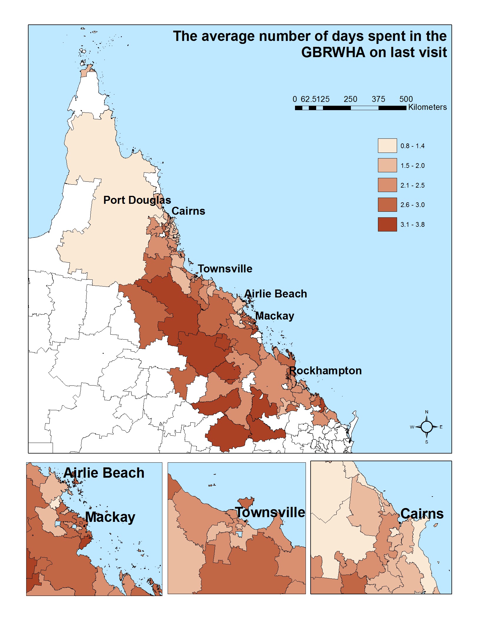
This data set in excel sheet format presents results of the mail survey of 1565 residents of the GBRWHA. The dataset is accompanied by a set of 58 maps that illustrate key findings.
Project 10.2 explored how visitors and residents feel towards and perceive Great Barrier Reef World Heritage Area, as well as their willingness to pay to protect the reef and their satisfaction with current and future developments in and around the GBRWHA.
Data were collected from the residents of the GBRWHA using a mail-out survey to a geographically stratified random sample of resident households in postcodes that lay partially or entirely within the study area. The pilot stage included 230 randomly selected households (2 from each of the postcodes identified), while the main mailing included about 40 households in each postcode. Following the Dilman (2007) methodology, we sent a reminder letter with replacement questionnaire to those who had not responded four weeks later, with a third reminder after that. We estimate that just under 4,000 questionnaires reached their intended recipients, and we received 902 completed questionnaires.
We were cognizant that some demographic groups are more likely to respond to mail-out surveys than others in these regions (e.g. young males, Indigenous people). Therefore we conducted supplementary face-to-face data-collection using the same questionnaire, across various public locations such as ferry terminals, airports and beaches. These extra activities generated an additional 663 responses, bringing the total number of completed resident questionnaires to 1565.
Data Format:
Excel data sheet with each row representing a postcode within the Great Barrier Reef Catchment Area and each column providing summary information about one variable (e.g. % or respondents who have never been to the GBRWHA). The GIS maps represent the data visually (one variable per map, showing responses for each postcode).
The original raw data cannot be published for privacy reasons. Data available here is a public form of the data, aggregated by postcode.
Further details of the project, including data collection and analysis methods, can be found in:
Stoeckl, N., Farr, M. and Sakata H. (2013) What do residents and tourists ‘value’ most in the GBRWHA? Project 10.2 interim report on residential and tourist data collection activities including descriptive data summaries. Report to the National Environmental research program. Reef and Rainforest Research Centre Limited, Cairn (pp112)
Simple
Identification info
- Date (Publication)
- 2014-08-03T00:00:00
- Cited responsible party
-
Role Organisation Name Telephone Delivery point City Administrative area Postal code Country Electronic mail address Principal investigator School of Business, James Cook University and The Cairns Institute Stoeckl, Natalie, Prof. Voice Townsville Queensland Australia natalie.stoeckl@jcu.edu.au Collaborator School of Business, James Cook University (JCU) Jarvis, Diane, Ms Voice facsimile Cairns Queensland Australia diane.jarvis@jcu.edu.au
- Status
- Completed
- Point of contact
-
Role Organisation Name Telephone Delivery point City Administrative area Postal code Country Electronic mail address Point of contact School of Business, James Cook University and The Cairns Institute Stoeckl, Natalie, Prof. Voice Townsville Queensland Australia natalie.stoeckl@jcu.edu.au
- Spatial representation type
- Text, table
- Topic category
-
- Society
Extent
Extent
))
- Keywords (Theme)
-
- marine
Resource constraints
- Use limitation
- In line with the national Ethical Conduct in Human Research guidelines and JCU Ethics Committee Approval for this research, raw data collected from individuals cannot be made publicly available. Rather, data is collated into meaningful units (postcodes) and presented as such.
- Access constraints
- Restricted
Resource constraints
- Linkage
-
http://i.creativecommons.org/l/by/2.5/au/88x31.png
License Graphic
- Title
- Creative Commons Attribution 2.5 Australia License
- Cited responsible party
-
Role Organisation Name Telephone Delivery point City Administrative area Postal code Country Electronic mail address
- Website
-
http://creativecommons.org/licenses/by/2.5/au/
License Text
- Language
- English
- Character encoding
- UTF8
Distribution Information
- OnLine resource
- Spreadsheet survey results summarised by postcode [54 kB, Excel]. This is the data used to create the maps.
- OnLine resource
- Project web site
Metadata
- Metadata identifier
- c64c924a-61e9-472f-a336-3cc0aa8271a9
- Language
- English
- Character encoding
- UTF8
- Contact
-
Role Organisation Name Telephone Delivery point City Administrative area Postal code Country Electronic mail address Point of contact JCU School of Business and The Cairns Institute Larson, Silva
Type of resource
- Resource scope
- Dataset
- Metadata linkage
-
https://eatlas.org.au/data/uuid/c64c924a-61e9-472f-a336-3cc0aa8271a9
Point of truth URL of this metadata record
- Date info (Creation)
- 2015-07-01T15:44:24
- Date info (Revision)
- 2015-07-01T15:44:24
Metadata standard
- Title
- ISO 19115-3:2018