 eAtlas Data Catalogue
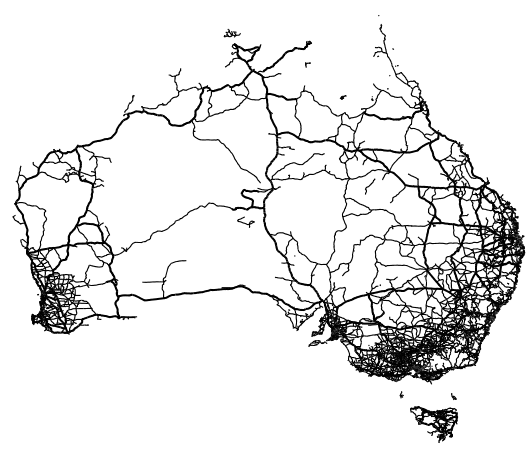
Australian Openstreetmap Major Roads December 2011 (NERP TE 13.1 eAtlas, source:Cloudmade)
This dataset contains the major roads for Australia, extracted from the OpenStreetMap project on December 2011 by CloudMade.
From the complete set of roads in the OpenStreetMap shapefile only major roads were extracted. This created a smaller high performance shapefile.
In ArcMap loaded the AU_CloudMade_OpenStreetMap-Dec-2011 shapefile then used the Analysis Tools/Extract/Select tool to extract the major roads.
Input Feature Class: australia_highway.shp
Output Feature Class: AU_OSM_MajorRoads.shp
"TYPE" = 'trunk' OR "TYPE" = 'trunk_link' OR "TYPE" = 'tertiary' OR "TYPE" = 'tertiary link' OR "TYPE" = 'tertiary; primary_link' OR "TYPE" = 'tertiary_link' OR "TYPE" = 'secondary_link' OR "TYPE" = 'secondary link' OR "TYPE" = 'secondary' OR "TYPE" = 'primary_link' OR "TYPE" = 'primary' OR "TYPE" = 'motorway' OR "TYPE" = 'motorway_link'
Simple
Identification info
- Date (Publication)
- 2013-08-14T13:33:00
- Purpose
- This dataset was prepared as part of the Bright Earth eAtlas Basemap dataset collection.
- Credit
- OpenStreetMap, CloudMade
- Status
- Completed
Principal investigator
Lawrey, Eric, DrAustralian Institute of Marine Science (AIMS)
- Spatial representation type
- Vector
- Topic category
-
- Transportation
Extent
Extent
))
Temporal extent
- Time position
- 2011-12-01T00:00:00
- Keywords
-
- Human Dimensions | Infrastructure | Transportation
Resource constraints
- Linkage
-
http://i.creativecommons.org/l/by-sa/2.5/au/88x31.png
License Graphic
- Title
- Creative Commons Attribution-Share Alike 2.5 Australia License
- Website
-
http://creativecommons.org/licenses/by-sa/2.5/au/
License Text
- Other constraints
- This dataset is derived from CloudMade which provides the following licensing advice: All of the files at downloads.cloudmade.com are based on data from OpenStreetMap and are licensed under the terms of the Creative Commons Attribution Share-Alike 2.0 license. If you use these files please make sure you attribute the OpenStreetMap community by including a link to www.openstreetmap.org. If you alter, transform, or build upon this work, you may distribute the resulting work only under the same or similar license to this one.
- Language
- English
- Character encoding
- UTF8
Distribution Information
- OnLine resource
- Australia Major Roads Shapefile (21MB)
- OnLine resource
- AU_CloudMade-OSM_MajorRoads_Dec-2011
- OnLine resource
- eAtlas Web Mapping Service (WMS) (AIMS)
Resource lineage
- Statement
- This dataset was derived from an extract of the OpenStreetMap database.
- Hierarchy level
- Dataset
Reference System Information
- Reference system identifier
- EPSG/EPSG:4326
Metadata
- Metadata identifier
- urn:uuid/df464abf-59be-41cc-a271-d17035582c4c
- Language
- English
- Character encoding
- UTF8
Point of contact
eAtlas Data ManagerAustralian Institute of Marine Science (AIMS)
- Parent metadata
Type of resource
- Resource scope
- Dataset
- Metadata linkage
-
https://eatlas.org.au/data/uuid/df464abf-59be-41cc-a271-d17035582c4c
Point of truth URL of this metadata record
- Date info (Creation)
- 2015-01-21T14:07:14
- Date info (Revision)
- 2023-09-18T07:19:03
Metadata standard
- Title
- ISO 19115-3:2018
Overviews
Spatial extent
Provided by
