
Recent datasets
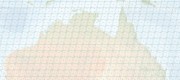
This dataset shows the tiling grid and their Row and Path IDs for Landsat 4 - 9 satellite imagery. The IDs are useful for selecting imagery of an area of interest. Landsat 4 - 9 are a series of Earth observation satellites, part of the US Landsat program aimed at monitoring Earth's land surfaces since 1982.
This project investigated the cause of the extensive areas of mangroves across the Gulf of Carpentaria which died in late 2015. Images from local fisherman showed extended impacted areas of more than 1,000 km where at least 7,400ha of mangroves had died in a matter of months. The project mapped the extent of the mass die-back, conducted aerial surveys to quantify shoreline condition, field studies to validate remote assessments and engaged with local aboriginal ranger groups to raise capacity for monitoring.
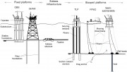
This dataset consists of an Excel spreadsheet representing an expert elicitation process of determining priority research areas for the decommissioning of ocean-based oil and gas structures. Further description of this process is provided in the 'Offshore decommissioning horizon scan: Research priorities to support decision-making activities for oil and gas infrastructure' paper by Sarah Watson et. al. 2023 https://doi.org/10.1016/j.scitotenv.2023.163015.
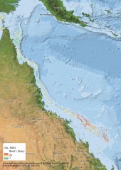
This dataset contains 63 shapefiles that represent the areas of relevance for each research project under the National Environmental Science Program Marine and Coastal Hub, northern and southern node projects for Rounds 1, 2 & 3.
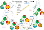
The major estuaries and their tidal wetlands of the Gulf of Carpentaria were impacted by mass dieback of mangroves in 2015-2016. To assess the full extent of the dieback and the major changes in the wetland areas, surveys in 2017 and 2019 were conducted along 31–37 major estuary mouths.
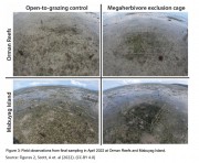
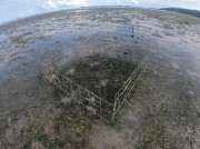
This dataset consists of seagrass shoot height and biomass assessments from an experiment which compared control plots to exclusion cage plots which prevented megaherbivore grazing. This experiment ran at two sites from September 2021 to April 2022.
This record provides an overview of the NESP Marine and Coastal Hub small-scale study - NESP Marine and Coastal Hub scoping study: New approaches to monitoring.
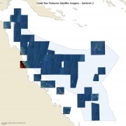
This dataset contains Sentinel 2 and Landsat 8 cloud free composite satellite images of the Coral Sea reef areas and some parts of the Great Barrier Reef. It also contains raw depth contours derived from the satellite imagery. This dataset was developed as the base information for mapping the boundaries of reefs and coral cays in the Coral Sea. It is likely that the satellite imagery is useful for numerous other applications. The full source code is available and can be used to apply these techniques to other locations.
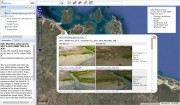
This dataset contains both large (A0) printable maps of the Torres Strait broken into six overlapping regions, based on a clear sky, clear water composite Sentinel 2 composite imagery and the imagery used to create these maps. These maps show satellite imagery of the region, overlaid with reef and island boundaries and names. Not all features are named, just the more prominent features. This also includes a vector map of Ashmore Reef and Boot Reef in Coral Sea as these were used in the same discussions that these maps were developed for.
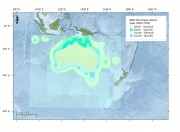
This vulnerability map results from integrating the spatial pattern of the following stressors: cyclonic waves, currents, cyclone tracks, heatwaves (DHW), crown of thorns starfish, and tsunamis. After summarizing historical data and reclassifying each variable into a common scale, they were integrated into a single vulnerability score whose spatial distribution is represented in this map.
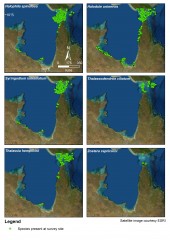
This dataset summarises 40 years of seagrass data collection (1983-2022) within Torres Strait and the Gulf of Carpentaria into two GIS shapefiles: (1) a point shapefile that includes survey data for 48,612 geolocated sites, and (2) a polygon geopackage describing seagrass at 641 individual or composite meadows.
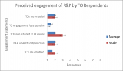
This dataset consists of one data file (CSV) from a nationally open survey for Aboriginal and Torres Strait Islander Peoples involved or interested in ecosystem restoration of marine and coastal habitats. The survey elicited 8 responses, although not all were complete, and gathered perceptions of engagement in restoration by researchers and practitioners.
This record provides an overview of the NESP Marine and Coastal Hub small-scale study "A roadmap for coordinated landscape-scale coastal and marine ecosystem restoration". For specific data outputs from this project, please see child records associated with this metadata.
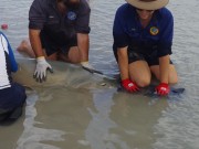
This record provides an overview of the NESP Marine and Coastal Hub small-scale study - "A pilot study into the movement and dispersal of sawfishes". For specific data outputs from this project, please see child records associated with this metadata.
This record provides an overview of the NESP Marine and Coastal Hub small-scale study - NESP MaC Project 1.29 a: Great Reef Census - a case study to integrate citizen science data into research output for marine habitat management". For specific data outputs from this project, please see child records associated with this metadata.
This record provides an overview of the NESP Marine and Coastal Hub small-scale study - "Regional planning in northern Australia: Building a community of practice and sentinel case studies for supporting improved approaches to achieve ESD".
This record provides an overview of the NESP Marine and Coastal Hub study - NESP MaC Project 3.19: Addressing Kakadu’s strategic marine research needs.
This record provides an overview of the NESP Marine and Coastal Hub small-scale study - "The role of dugong and turtle grazing in Torres Strait seagrass declines". For specific data outputs from this project, please see child records associated with this metadata.
This record provides an overview of the NESP Marine and Coastal Hub small-scale - "Scoping Study: Supporting Regional Planning in Northern Australia".
This record provides an overview of the NESP Marine and Coastal Hub small-scale study - "Protected Places Mission Scoping Study".