
NESP TWQ Round 2 - Project 2.1.4 - Demonstration and evaluation of gully remediation on downstream water quality and agricultural production in GBR rangelands
This project established baseline sites for evaluating the cost, effectiveness and biophysical processes of gully remediation options in the Burdekin Region. Sub-surface soil erosion is the major source of anthropogenic sediment delivered to the Great Barrier Reef and must be addressed to help meet Reef water quality targets. The Reef Trust Gully Erosion Control Programme is the first to focus on gully remediation. This study evaluated the impact of gully remediation options to underpin future investor, stakeholder and public confidence in the impact of erosion control programmes on
- water quality
- project cost-effectiveness and
- agricultural production.
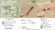
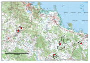
This project established 5 paired Control/Treatment gully sites on commercial grazing properties in the Bowen, Upper Burdekin catchments. These sites compared a range of gully erosion mitigation interventions (treatments) against nearby control gullies. At each site the erosion rates of the gully and the quality of the water runoff was monitored to establish the effectiveness of each treatment.
The monitoring of these sites was extended as part of NESP TWQ Project 5.9 to better evaluate the effectiveness of the treatments over a longer period of time.
The reports for this project can be found at the NESP TWQ Project 2.1.4 Hub website.
Images
Datasets
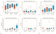
This dataset contains RTK GPS Data collected between April, 2017 and March, 2018 for 5 paired Control/Treatment gully sites being monitored as part of NESP Project 2.1.4 (Demonstration and evaluation of gully remediation on downstream water quality and agricultural production in GBR rangelands). The key question being asked is “is there measurable improvement in the erosion and water quality leaving remediated gully sites compared to sites left untreated?” The monitoring approach uses a modified BACI (Before after control impact) design.
An updated version of this dataset is available at https://eatlas.org.au/data/uuid/38b496a3-3fba-42e7-b904-902f68040c85
This dataset contains Vegetation and Biomass monitoring data collected for the NESP Project 2.1.4 (Demonstration and evaluation of gully remediation on downstream water quality and agricultural production in GBR rangelands). The aim of the vegetation monitoring in relation to this project is to track change in biomass and species composition over time on hillslope areas above gully erosion within control and treatment sites (treatments vary), linking to changes in downstream water quality.

Five paired Control/Treatment gully sites on commercial grazing properties in the Upper Burdekin and Bowen catchments are being monitored as part of NESP Project 2.1.4 (Demonstration and evaluation of gully remediation on downstream water quality and agricultural production in GBR rangelands) (Bartley et al., 2018).
The key question being asked is: "Is there measurable improvement in the erosion and water quality leaving remediated gully sites compared to sites left untreated?" The monitoring approach uses a modified BACI (Before after control impact) design.
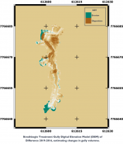
This dataset contains Riegl terrestrial laser scanner scans and their derived 5 cm gridded digital elevation models (DEMs) collected for up to 4 years between 2016 and 2019 for 4 paired Control/Treatment gully sites being monitored as part of NESP Project 2.1.4. Data collection also contains the DEMs of difference used to estimate changes in gully volume.