 eAtlas Data Catalogue
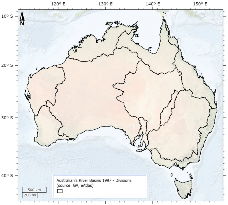
Australia's River Basins 1997 - Divisions (eAtlas, source: GA)
This dataset is derived from the Australia's River Basins 1997 (GA) dataset. It shows the 12 drainage divisions. Primary credit should be given to Geoscience Australia.
This dataset was created by using ArcMap to dissolve polygons from the Australia's River Basins 1997 shapefile based on the DNAME attribute.
Simple
Identification info
- Date (Publication)
- 2014-09-25T00:00:00
- Date (Creation)
- 1997-06-01T00:00:00
- Status
- Completed
Point of contact
Lawrey, Eric, DrAustralian Institute of Marine Science (AIMS)
PRIVATE MAIL BAG 3, TOWNSVILLE MAIL CENTRE
Townsville
Queensland
4810
Australia
- Spatial representation type
- Vector
Spatial resolution
Equivalent scale
- Denominator
- 250000
- Topic category
-
- Boundaries
Extent
Extent
- Description
- Australia
N
S
E
W
))
Temporal extent
- Time position
- 1997-06-30T00:00:00
- anzlic-theme
-
- BOUNDARIES
- WATER Hydrology
- Keywords (Theme)
-
- GIS
- National dataset
- environmental
- hydrology
- mapping
- catchments
Resource constraints
- Access constraints
- Copyright
Resource constraints
- Linkage
-
http://i.creativecommons.org/l/by/3.0/au/88x31.png
License Graphic
- Title
- Creative Commons Attribution 3.0 Australia License
- Website
-
http://creativecommons.org/licenses/by/3.0/au/
License Text
- Language
- English
- Character encoding
- UTF8
- Supplemental Information
- au_eatlas_rbasin_1997_divisions_polygon.shp (6 MB, 12polygons, Datum: AGD66): This shapefile contains the divisions from the Australia River Basins 1997 dataset. It contains one attribute: DNAME which contains one of the following division names: BULLOO-BANCANNIA, GULF OF CARPENTARIA, INDIAN OCEAN, LAKE EYRE, MURRAY-DARLING, NORTH-EAST COAST, SOUTH-EAST COAST, SOUTH-WEST COAST, SOUTH AUSTRALIAN GULF, TASMANIA, TIMOR SEA, WESTERN PLATEAU
Distribution Information
- Distribution format
-
- DIGITAL - shp ArcView shape file ArcView Geographic AGD66
- DIGITAL - shp ArcView shape file ArcView Geographic AGD66
- OnLine resource
- Australia's River Basins 1997, Geoscience Australia, Free data download page [MapInfo and PDF] and original metadata.
- OnLine resource
- ea:AU_GA_River-basins-1997_Divisions
- OnLine resource
- eAtlas Web Mapping Service (WMS) (AIMS)
- OnLine resource
- Australian's River Basins 1997 Divisions [Shapefile Zip 6MB]
Resource lineage
- Statement
- Data for basin boundaries have been captured by relevant State and Territory authorities from 1:10 000 and 1:250 000 scale source material. The balance of the data are from Geoscience Australia's GEODATA Coast 100K which includes coastlines and State and Territory borders. Australia's River Basin data complies with the following rules for topology: - The data has a node/chain structure; - Every line feature has a node at each end; - Every line feature has a node at intersections; - Every line feature has a node at the point where an attribute of the feature changes; - There are no unnecessary pseudo nodes; - Every polygon is closed; - Every polygon contains a polygon label point; - There are no coincident features; - There are no undershoots, overshoots, broken lines or other artefacts; - Divisions, Regions or Basins that are intersected by State borders have identical label point attributes each side of the State border; and - Lines intersected by State borders, except for coastline, have identical attributes.
- Hierarchy level
- Dataset
Reference System Information
- Reference system identifier
- EPSG/EPSG:4202
Metadata
- Metadata identifier
- urn:uuid/039e74aa-be9b-4935-8160-5c0c5c50e53f
- Language
- English
- Character encoding
- UTF8
Point of contact
Lawrey, Eric, DrAustralian Institute of Marine Science (AIMS)
PRIVATE MAIL BAG 3, TOWNSVILLE MAIL CENTRE
Townsville
Queensland
4810
Australia
- Parent metadata
Type of resource
- Resource scope
- Dataset
- Metadata linkage
-
https://eatlas.org.au/data/uuid/039e74aa-be9b-4935-8160-5c0c5c50e53f
Point of truth URL of this metadata record
- Date info (Creation)
- 2014-09-25T14:39:26
- Date info (Revision)
- 2023-09-18T08:18:12
Metadata standard
- Title
- ISO 19115-3:2018
Overviews
large_thumbnail
Spatial extent
N
S
E
W
Provided by

Associated resources
Not available