 eAtlas Data Catalogue
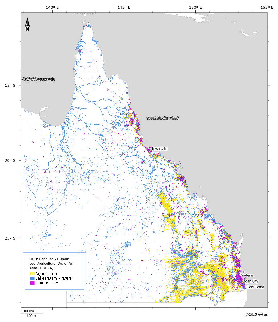
Queensland Landuse (QLUMP) - Bright Earth Classification 1999-2012 (NERP TE 13.1 eAtlas, source: DSITIA)
This dataset is subset and aggregation of the current Queensland land use dataset (1999 - 2012) by Queensland Land Use Mapping Program (QLUMP) produced by the Queensland Government. The land use data was classified and aggregated into areas that represent Human Use, Agriculture and Water areas such as lakes and rivers.
Simple
Identification info
- Date (Publication)
- 2013-08-20T00:00:00
- Purpose
- This classification was developed for the Bright Earth basemap to highlight areas influenced by human use, whilst working with the brightened blue marble imagery.
- Status
- Completed
Principal investigator
Lawrey, Eric, DrAustralian Institute of Marine Science (AIMS)
PRIVATE MAIL BAG 3, TOWNSVILLE MAIL CENTRE
Townsville
Queensland
4810
Australia
- Topic category
-
- Imagery base maps earth cover
Extent
Extent
N
S
E
W
))
Temporal extent
- Time position
- 1999-01-01T00:00:00
- Time position
- 2012-01-20T00:00:00
Resource constraints
- Linkage
-
http://i.creativecommons.org/l/by/2.5/au/88x31.png
License Graphic
- Title
- Creative Commons Attribution 2.5 Australia License
- Website
-
http://creativecommons.org/licenses/by/2.5/au/
License Text
- Language
- English
- Character encoding
- UTF8
Distribution Information
- OnLine resource
- eAtlas Web Mapping Service (WMS) (AIMS)
- OnLine resource
- Interactive map of this dataset
- OnLine resource
- ea-be:QLD_eAtlas-DSITIA_Bright-earth-Landuse_1999-2012
- OnLine resource
- eAtlas project page
Resource lineage
- Hierarchy level
- Dataset
Reference System Information
- Reference system identifier
- EPSG/EPSG:4283
Metadata
- Metadata identifier
- 83b01748-7fe5-418b-aa8d-b972ea62dab6
- Language
- English
- Character encoding
- UTF8
Point of contact
eAtlas Data ManagerAustralian Institute of Marine Science (AIMS)
PRIVATE MAIL BAG 3, TOWNSVILLE MAIL CENTRE
Townsville
Queensland
4810
Australia
- Parent metadata
Type of resource
- Resource scope
- Dataset
- Metadata linkage
-
https://eatlas.org.au/data/uuid/83b01748-7fe5-418b-aa8d-b972ea62dab6
Point of truth URL of this metadata record
- Date info (Creation)
- 2015-12-14T14:27:44
- Date info (Revision)
- 2015-12-14T14:27:44
Metadata standard
- Title
- ISO 19115-3:2018
Overviews
large_thumbnail
Spatial extent
N
S
E
W
Provided by

Associated resources
Not available