 eAtlas Data Catalogue
Key Localities Gully Remediation (NESP TWQ 2.1.4, CSIRO)
An updated version of this dataset is available at https://eatlas.org.au/data/uuid/38b496a3-3fba-42e7-b904-902f68040c85
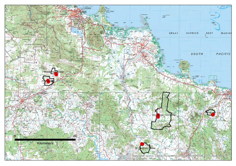
Key Gully monitoring localities (headcuts and monitoring instrumentation) and outlines of the properties within which they are located. The data in presented in this metadata are part of a larger collection and are intended to be viewed in the context of the project. For further information on the project, view the parent metadata record: Demonstration and evaluation of gully remediation on downstream water quality and agricultural production in GBR rangelands (NESP TWQ 2.1.4, CSIRO)
Methods:
Key Gully Localities were extracted from the 2017 or 2018 RTK GPS surveys for each gully site (see Site_Configuration_and_Survey).
Property Boundaries were generated by extracting polygons from the 2016 Digital Cadastre Database (DCDB) and simplifying to a single polygon. Area in hectares was calculated and appended to polygon attributes.
KMZ’s are exported version of the original ArcGIS shapefiles
Format:
This data collection consists of two shapefiles (zipped) and two equivalent KMZ files with the following names:
NESP_Gully_Key_localities
Key gully localities include the RTK GP location of the instrumentation and the RTK GPS location of the nickpoint in the gully headcut rim.
NESP_Gully_Property_Boundaries
Boundaries for the properties on which the paired control/treatment gullies are located.
Data Dictionary:
Attributes for Property_Boundaries.shp include property NAME and the area in hectares (AREA_HA).
Attributes for Key Locations include
X,Y (MGA94 Z55) and Z (AHD)
Timestamp associated when RTK surveyed
Type- HEADCUT, INSTR
Survey – type of survey and year, APPROX is best guess from Lidar or GoogleEarth
Site_Code – short form code for sites where
MIV = Minnievale
MV = Meadowvale
MW = Mount Wickham
SB = Strathbogie
VP = Virginia Park
<T/C> - Treatment/Control
Property – Full name of property
Treat_type – Treatment or control
References:
Bartley, Rebecca; Hawdon, Aaron; Henderson, Anne; Wilkinson, Scott; Goodwin, Nicholas; Abbott, Brett; Baker, Brett; Matthews, Mel; Boadle, David; Jarihani, Ben (Abdollah). (2018) Quantifying the effectiveness of gully remediation on off-site water quality: preliminary results from demonstration sites in the Burdekin catchment (second wet season). RRRC: NESP and CSIRO. csiro:EP184204.
Data Location:
This dataset is filed in the eAtlas enduring data repository at: data\NESP2\2.1.4_Gully-remediation-effectiveness
Simple
Identification info
- Date (Creation)
- 2019-07-02
- Date (Publication)
- 2019-08-23
Principal investigator
Bartley, Rebecca DrCSIRO Land and Water
Collaborator
Henderson, AnneCSIRO Land and Water
Collaborator
Hawdon, AaronCSIRO Land and Water
Point of contact
Bartley, Rebecca DrCSIRO Land and Water
- Topic category
-
- Environment
Extent
Extent
- Description
- Great Barrier Reef, Australia

Temporal extent
- Time period
- 2016-07-01 2018-06-30
Resource constraints
- Linkage
-
http://i.creativecommons.org/l/by/3.0/au/88x31.png
License Graphic
- Title
- Creative Commons Attribution 3.0 Australia License
- Website
-
http://creativecommons.org/licenses/by/3.0/au/
License Text
- Language
- English
- Character encoding
- UTF8
Distribution Information
- OnLine resource
- NESP TWQ Project page
- OnLine resource
- eAtlas Web Mapping Service (WMS) (AIMS)
- OnLine resource
- Project web site
- OnLine resource
- KMZ + Shapefile + Metadata + JPG [Zip 14.2 MB]
- OnLine resource
- Interactive map of this dataset
- OnLine resource
- nesp2:QLD_NESP-TWQ-2-1-4_CSIRO_Gully-remediation_Key-localities_20190702_Property_Boundaries
- OnLine resource
- nesp2:QLD_NESP-TWQ-2-1-4_CSIRO_Gully-remediation_Key-localities_20190702_Key-localities
- OnLine resource
- Updated version of this dataset
Metadata constraints
- Linkage
-
http://i.creativecommons.org/l/by/3.0/au/88x31.png
License Graphic
- Title
- Creative Commons Attribution 3.0 Australia License
- Website
-
http://creativecommons.org/licenses/by/3.0/au/
License Text
Metadata
- Metadata identifier
- urn:uuid/8f8a1058-e561-4771-a879-f308ca10ddf4
- Language
- English
- Character encoding
- UTF8
Point of contact
eAtlas Data ManagerAustralian Institute of Marine Science (AIMS)
Type of resource
- Resource scope
- Dataset
- Metadata linkage
-
https://eatlas.org.au/data/uuid/8f8a1058-e561-4771-a879-f308ca10ddf4
Point of truth URL of this metadata record
- Date info (Creation)
- 2021-03-31T11:26:49
- Date info (Revision)
- 2023-09-18T08:57:12
Metadata standard
- Title
- ISO 19115-3:2018
Overviews
Spatial extent

Provided by
