 eAtlas Data Catalogue
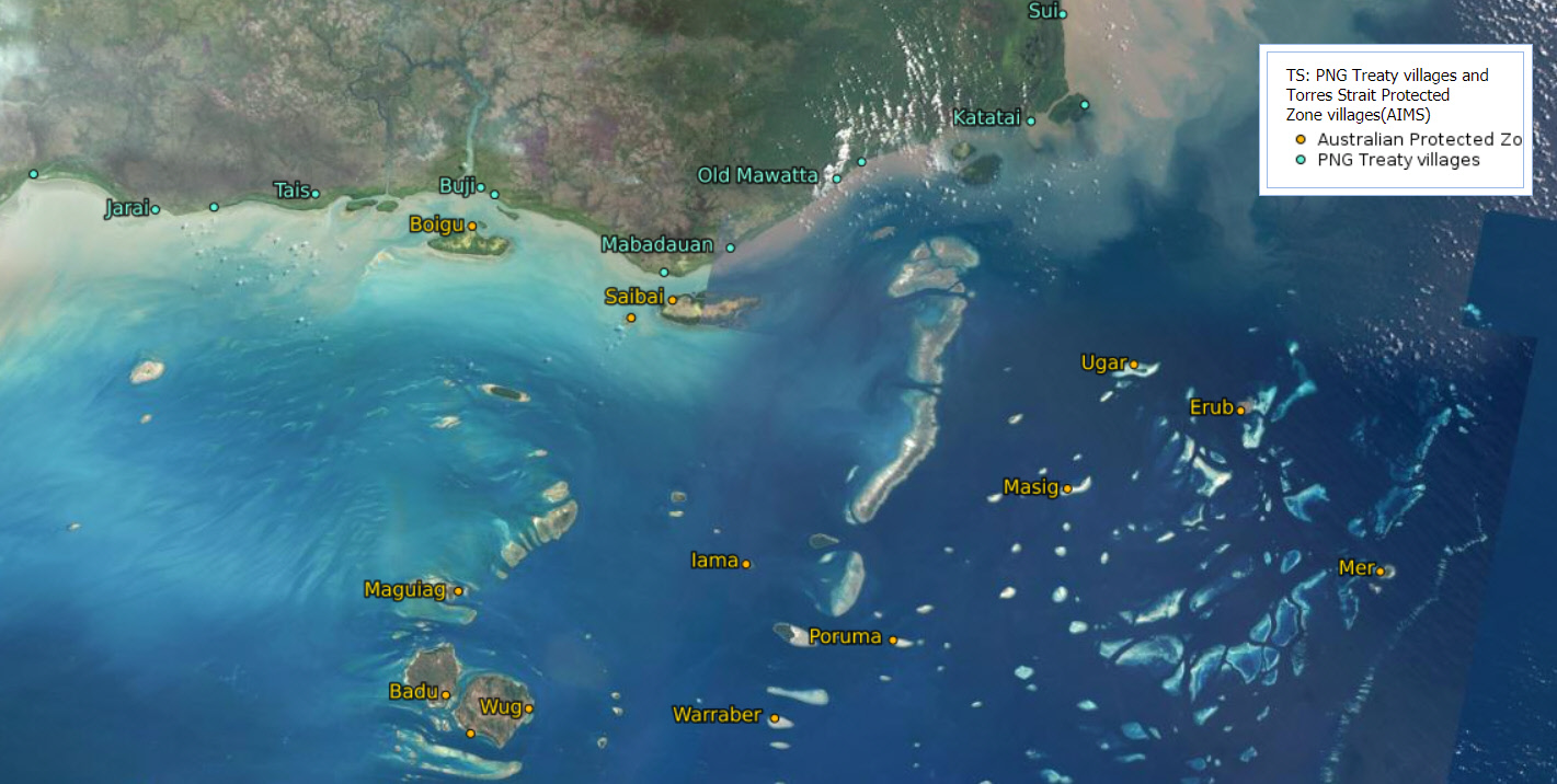
Locations of Torres Strait Protected Zone and PNG Treaty Villages (AIMS)
This dataset consists of a small CSV file containing the locations, names and country of the Torres Strait villages associated with the Australian and Papua New Guinea Treaty Protected Zone and neighbouring PNG Treaty villages This dataset is intended for the creation of regional maps.
The village locations are not official and were based using satellite imagery to place the village marker on either the centre of the visible village, or the post office location, if that was marked in Google Maps.
In 2000, Australia and PNG exchanged third person notes which identified the PNG villages deemed to be Treaty villages. Thus, PNG inhabitants from the 13 Treaty villages—Bula, Mari, Jarai, Tais, Buji/Ber, Sigabadaru, Mabadauan, Old Mawatta, Ture Ture, Kadawa, Katatai, Parama and Sui—can, without passports, visit the Protected Zone to carry out traditional activities. Torres Strait Islanders living in the Protected Zone have reciprocal rights to visit the Treaty villages to also carry out traditional activities.
The spelling of the names of the villages were based on the maps and text provided on the Torres Strait Island Regional council website at http://www.tsirc.qld.gov.au/community-entry-forms/treaty-png-border-movements.
This contains the villages locations for: Parama, Buji, Bula, Sigabadaru, Sui, Tais, Ture Ture, Ber, Kadawa, Katatai, Old Mawatta, Mari, Mabadauan, Jarai, Boigu, Badu, Poruma, Erub, Dauan, Arkai, Wug, Maguiag, Mer, Saibai, Ugar, Warraber, Iama, Masig
Format:
CSV file containing 28 rows and 4 columns (longitude, latitude, name, country)
Data Dictionary:
longitude, latitude: Decimal degrees of the village location. This was adjusted to be central to the village, or at the location of the post office if this was marked on Google Maps and it appeared to be a valid location.
name: Name of the village with spelling based on the Torres Strait Regional Council website.
country: Country that the village is in. Either 'PNG' or 'Australia'
References:
Torres Strait Regional Council (2016) Torres Strait Treaty & Border Movements. Accessed 12 April 2021 from http://www.tsirc.qld.gov.au/community-entry-forms/treaty-png-border-movements
Senate Foreign Affairs, Defence and Trade Committee (2010) The Torres Strait: Bridge and Border. Senate Printing Unit, Parliament House, Canberra. https://www.aph.gov.au/Parliamentary_Business/Committees/Senate/Foreign_Affairs_Defence_and_Trade/Completed_inquiries/2010-13/torresstrait/report/index
Simple
Identification info
- Date (Creation)
- 2021-04-12
- Date (Publication)
- 2021-04-12T00:00:00
Principal investigator
Lawrey, Eric, DrAustralian Institute of Marine Science (AIMS)
Point of contact
eAtlas Data ManagerAustralian Institute of Marine Science (AIMS)
- Spatial representation type
- Text, table
- Topic category
-
- Society
Extent
Extent
- Description
- Torres Strait / PNG Protected Zone

Temporal extent
- Time period
- 2000-07-25 2021-04-12
Resource constraints
- Linkage
-
http://i.creativecommons.org/l/by/3.0/au/88x31.png
License Graphic
- Title
- Creative Commons Attribution 3.0 Australia License
- Website
-
http://creativecommons.org/licenses/by/3.0/au/
License Text
- Language
- English
- Character encoding
- UTF8
Distribution Information
- OnLine resource
- eAtlas Web Mapping Service (WMS) (AIMS)
- OnLine resource
- Shapefile + CSV + Metadata [Zip 5 kB]
- OnLine resource
- Interactive map of this dataset
- OnLine resource
- ts:TS_AIMS_PNG-Treaty-villages_v202104
- OnLine resource
- The Torres Strait Treaty, DFAT
Metadata constraints
- Linkage
-
http://i.creativecommons.org/l/by/3.0/au/88x31.png
License Graphic
- Title
- Creative Commons Attribution 3.0 Australia License
- Website
-
http://creativecommons.org/licenses/by/3.0/au/
License Text
Metadata
- Metadata identifier
- urn:uuid/e121d096-6623-4c1e-a656-fe3b7abcb309
- Language
- English
- Character encoding
- UTF8
Point of contact
eAtlas Data ManagerAustralian Institute of Marine Science (AIMS)
Type of resource
- Resource scope
- Dataset
- Metadata linkage
-
https://eatlas.org.au/data/uuid/e121d096-6623-4c1e-a656-fe3b7abcb309
Point of truth URL of this metadata record
- Date info (Creation)
- 2021-04-12T02:21:45
- Date info (Revision)
- 2023-09-18T07:17:19
Metadata standard
- Title
- ISO 19115-3:2018
Overviews
Spatial extent

Provided by
