 eAtlas Data Catalogue
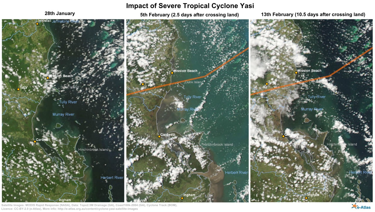
Before and after cyclone Yasi MODIS satellite imagery (NERP TE 13.1, eAtlas, AIMS, source: NASA)
This collection is a record of MODIS satellite imagery before, during and after severe cyclone Yasi in February 2011. This image series highlights the damage the cyclone makes to the rainforest areas around mission beach and the turbulence created off shore by the cyclone on the 5th February (2.5 days after the cyclone). It corresponds to the images and maps from the "Cyclone Yasi satellite image maps - before and after" article in the eAtlas. Use this dataset if you wish to recreate these maps.
The imagery in this collection was sourced from the NASA rapid response site and consists of georeferenced JPEG images. This collection contains the raw georeferenced satellite imagery as well as a number of maps that include rivers, towns, coastline and cyclone Yasi's track. The data used to create these maps is included in the data package. This includes Australian Coast100k 2004 (Geoscience Australia), Australian Topo2M5-2003 Drainage (Geoscience Australia), Natural earth 10m Cities and Yasi track BOM (Bureau of Meteorology).
This series contains images for 28th January, 2nd February (1 day before land crossing), 5th February (2.5 days after crossing land) and 13th February (10.5 days after crossing land). These images cover most of the Great Barrier Reef, the coral sea and the Queensland coastline.
Format:
This dataset contains original georeferenced NASA Rapid Response JPEG images (6400x6400 pixels), shapefiles for Coast 100k, Topo 2M5 Drainage, 10m cities and Yasi track. It also contains the original Yasi track as locations and an R script to convert this to a shapefile. It also contains an ArcMap MXD file that uses all the data files to create the maps that combine the satellite imagery with the shapefiles; these maps are provided in JPEG and PNG exports. Additonally it contains an SVG (Scalar Vector Graphic) file (made in Inkscape) for creating the before and after comparison map.
The maps are based on the follow NASA Rapid Response images:
Australia3.2011028.terra.250m
Australia3.2011033.aqua.250m
Australia3.2011036.aqua.250m
Australia3.2011043.aqua.250m
Change Log:
2016-05-16 - Corrected the date labels in some of the exported maps. Three of then were labelled with 2010 instead of the correct year 2011.
Repository Location:
This dataset is saved in the eAtlas enduring data repository at: data\NERP-TE\13.1_eAtlas\GBR_eAtlas-NASA_Yasi-before-after-MODIS_2011
Simple
Identification info
- Date (Publication)
- 2015-10-28
- Date (Revision)
- 2016-05-16T00:00:00
Principal investigator
Lawrey, Eric, DrAustralian Institute of Marine Science (AIMS)
Point of contact
Lawrey, Eric, DrAustralian Institute of Marine Science (AIMS)
- Spatial representation type
- Grid
- Topic category
-
- Climatology, meteorology, atmosphere
Extent
Extent
- Description
- Great Barrier Reef, Australia
))
Temporal extent
- Time position
- 2011-01-28T00:00:00
- Time position
- 2011-02-13T00:00:00
- Keywords (Theme)
-
- marine
Resource constraints
- Linkage
-
http://i.creativecommons.org/l/by/3.0/au/88x31.png
License Graphic
- Title
- Creative Commons Attribution 3.0 Australia License
- Website
-
http://creativecommons.org/licenses/by/3.0/au/
License Text
- Language
- English
- Character encoding
- UTF8
Distribution Information
- OnLine resource
- Project web site
Metadata constraints
- Linkage
-
http://i.creativecommons.org/l/by/3.0/au/88x31.png
License Graphic
- Title
- Creative Commons Attribution 3.0 Australia License
- Website
-
http://creativecommons.org/licenses/by/3.0/au/
License Text
Metadata
- Metadata identifier
- urn:uuid/5ee1b965-a4ad-41ca-8cce-aa1dfbe69c82
- Language
- English
- Character encoding
- UTF8
Point of contact
eAtlas Data ManagerAustralian Institute of Marine Science (AIMS)
- Parent metadata
Type of resource
- Resource scope
- Dataset
- Metadata linkage
-
https://eatlas.org.au/data/uuid/5ee1b965-a4ad-41ca-8cce-aa1dfbe69c82
Point of truth URL of this metadata record
- Date info (Creation)
- 2017-11-28T13:02:14
- Date info (Revision)
- 2023-09-18T09:09:30
Metadata standard
- Title
- ISO 19115-3:2018
Overviews
Spatial extent
Provided by
