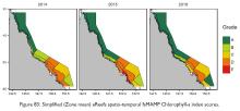
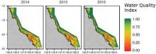
NESP TWQ Round 3 - Project 3.2.5 - Testing and implementation of the water quality metric for the 2017 and 2018 reef report cards

Region map

The Reef 2050 Water Quality Improvement Plan (Reef Plan) guides how industry, government and the community will work together to improve the quality of water flowing into the Great Barrier Reef (GBR). Foundational to the water quality theme of Reef 2050 Long-term Sustainability Plan, the Reef Plan is a joint commitment of the Australian and Queensland governments to address all land-based run-off flowing from the catchments adjacent to the GBR. The plan sets the strategic priorities for the whole Reef catchment. Regional Water Quality Improvement Plans, developed by regional natural resource management bodies, support the Reef Plan in providing locally relevant information and guiding local priority actions within regions.

The annual Great Barrier Reef Report Card (Report Card), which is integrating the information from a range of programs monitoring and modelling land management practices, pollutant levels and the condition of the GBR and its catchments, is the main mechanism to evaluate progress towards targets and identify whether further measures need to be taken to address water quality in the GBR. In previous Report Cards (until 2015), marine water quality was reported using a metric based on satellite remote sensing of near surface concentrations of chlorophyll and total suspended solids, which provided a wide spatial and temporal coverage of marine water quality which cannot be achieved with in situ observations.

Index scores for these indicators were calculated based on the relative area of the inshore water body that did or did not exceed the relevant GBRMPA Water Quality Guidelines (GBRMPA 2010). Scores for Chl-a and NAP were aggregated (averaged) into a final metric value subsequently converted into a final grade on a five-point uniform scale (translated into grading statements: very good, good, moderate, poor, very poor) for each Natural Resource Management (NRM) Region. This final grade describes the overall water quality condition across the GBR and within each individual NRM Region. Complementing the Report Card metric, the results of in situ monitoring of water quality have been reported annually to provide detailed, site-specific information on temporal trends and spatial patterns (See 2016 summary report and the detailed reports from the Marine Monitoring Program).

The water quality metric used underpinning previous Report Cards (until 2015) presented a number of significant shortcomings:

  • It was solely based on remote sensing-derived data. Concerns were raised about the appropriateness of exclusively relying on remote sensing to evaluate inshore water quality, considering well-documented challenges in obtaining accurate estimates from optically complex waters and the fact that only limited valid satellite observations are available in the wet season due to cloud cover;
  • It was limited to reporting on two indicators and did not incorporate other water quality data and indicators collected through the Marine Monitoring Program (MMP) and the Integrated Marine Observing System (IMOS);
  • It appeared relatively insensitive to large terrestrial inputs into the GBR lagoon during large rainfall and runoff events, most likely due to the binary assessment of compliance relative to the water quality guidelines and aggregation and averaging over large spatial and temporal scales;

In 2016, based on the limitations described above, the Reef Plan Independent Science Panel (ISP) expressed a lack of confidence in the water quality metric that underpinned Report Cards (prior to 2015) and recommended that a new approach be identified for the Report Card 2016 and future Report Cards. The ISP also acknowledged substantial advancements in modelling water quality through the eReefs biogeochemical models and the fact that recent research and method development had improved our ability to construct report card metrics. To address the above shortcomings, the ISP requested that:

  • The e-Reefs marine biogeochemical (BGC) model be tested for its ability to deliver a better water quality assessment than the current practice based on remote sensing;
  • The GBRMPA water quality guidelines be reviewed to incorporate new evidence collected over the last 6-8 years in understanding coral and seagrass responses to chronic and acute pressures, ecosystem health, recovery and resilience;
  • The utility of observational data streams from in-situ monitoring is analysed for potential inclusion in Report Card;
  • The current practice of scoring relative to water quality guidelines and aggregating data over fixed spatial and temporal scales be improved to incorporate the magnitude, frequency and duration of exceedance rather than simply using average annual exceedance counts;
  • The inclusion of photic depth, as derived from satellite data, into the metric be evaluated since light is the important driver for coral and seagrass productivity. The most appropriate measure of photic depth can be evaluated and related to seagrass and coral responses; and
  • Options for combining indicator scores into a single metric are evaluated, including a statistical assessment of potential metrics.

These recommendations were the basis for formulating this NESP 3.2.5 project entitled “Testing and implementation of an improved water quality index for the 2016 and 2017 Great Barrier Reef Report Cards”. Conducted as a collaboration between GBRMPA, AIMS, CSIRO and JCU, the high-level objective for this project were to identify, investigate and assess alternative strategies to integrate available monitoring and modelling data into an improved water quality metric for the GBR marine waters.

Project outcomes and recommendations

  • The systematic analysis and comparison of different sources of water quality data (in situ water sampling, continuous fluorescence loggers, eReefs BGC model and satellite data) available to derive a water quality metric did not lead to a recommendation to exclude any specific source of information.
  • An innovative data assimilation scheme was developed to assimilate satellite reflectance information into the eReefs BGC model. Extensive validation and model skill assessment was conducted to demonstrate the performance of the assimilating model, including individual time series comparisons and absolute and normalised error statistics across all observation locations.
  • Strategies to integrate these data sources were developed and evaluated. Approaches based on the direct aggregation of independent data sources were shown to be deficient due to the radically different spatial and temporal distributions of the data. The preferred approach was to assimilate satellite reflectance information into the eReefs BGC model and to rely on in situ measurements for validation of the model performance.
  • Index scoring strategies were systematically assessed to meet key objectives of sensitivity and representativeness, to allow data aggregation and to enable the integration of additional water quality measures when these become available in the future. A preferred method was identified as the scaled modified amplitude method with fixed caps sets at half and twice the threshold values, which was tested both theoretically and using historical datasets.
  • Aggregation strategies were reviewed and a hierarchical aggregation scheme was developed to allow multiple measures and sub-indicators to be combined into a single metric and to allow spatial and temporal aggregation. The process was designed to maintain the richness of information and allow the propagation of uncertainty, which were key project objectives.
  • The resulting water quality metric calculation process and parameters were applied to the development of the marine water quality metric component of Reef Report Card 2016, covering the reporting period 1 October 2015 to 30 September 2016.

A detailed description of the project and its outcomes can be found in the final report.

Note: The project lead changed during the project from Dr. Britta Schaffelke to Dr. Cedric Robillot.

NESP TWQ Project Page

Images

Datasets

9 March 2021

The dataset represents the code base developed for the generation of water quality metrics from various data sources (eReefs Biogeochemical models, MODIS Satellite imaging and AIMS in situ sampling).