NESP TWQ Round 4 - Project 4.8 - ‘Project 25’ – farmers, water quality and on-farm decision-making
Landholder concerns surrounding the credibility of broad-scale water quality monitoring and modelling initiatives in the GBR catchment area is emerging as one of the key cane industry engagement challenges for promoting significant farming practice change, and delivering water quality improvements. Based around small, sub-catchment scale water quality monitoring in a key cane growing region of the GBR catchment, Project 25 utilises a bottom-up approach to integrated sub-catchment monitoring and intervention to identify ‘hot spot’ sub-catchments through localised water quality monitoring. The Project emphasises industry ownership and control of monitoring design, and delivery of locally targeted water quality data to provide confidence in on-farm decision making and practice change.
Images
Datasets

Landholder concerns surrounding the credibility of broad-scale water quality monitoring and modelling initiatives in the GBR catchment area is emerging as one of the key cane industry engagement challenges for promoting significant farming practice change, and delivering water quality improvements. Based around small, sub-catchment scale water quality monitoring in a key cane growing region of the GBR catchment, Project 25 utilises a bottom-up approach to integrated sub-catchment monitoring and intervention to identify ‘hot spot’ sub-catchments through localised water quality monitoring.

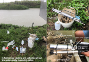
This dataset contains the results of the real-time water quality monitoring program (RTWQM) conducted across the Russell-Mulgrave catchment (south of Cairns) for "Project 25". Project 25 spanned two (2) NESP TWQ projects: 2.1.7 (2016 - 2018) and 4.8 (2019 - 2020), with the dataset for Project 4.8 also containing the data for Project 2.1.7. Data is the result of 2-3 hourly in situ logging of stream height (in metres) and nitrate concentrations (mg/L).
* This dataset is under an embargo period for 18 months from the completion of the project extension (NESP TWQ 4.8).

This dataset contains the results of the water quality monitoring program conducted across the Russell-Mulgrave catchment (south of Cairns) for "Project 25". Project 25 spanned two (2) NESP TWQ projects: 2.1.7 (2016 - 2018) and 4.8 (2019 - 2020), with the dataset for Project 4.8 also containing the data for Project 2.1.7. Data is the result of discrete ‘grab’ samples analysed at TropWATER JCU laboratory for nutrients and sediments.


