1. Introduction - 2. Money Shoal - 2a. Fish and Sharks - 2b. Benthic communities - 3. Acknowledgement
1. Introduction
This article is a summary of one in a series of eco-narrative documents that synthesise our existing knowledge of Australian Marine Parks (Arafura Marine Park Eco-narrative). These documents are intended to enable managers and researchers to ascertain the ecological characteristics of each park, and to highlight knowledge gaps for future research focus. The information in this eco-narrative forms an initial characterisation of the physical, oceanographic and biological character of Arafura Marine Park, with a focus on results from a biodiversity and mapping survey undertaken by the NESP Marine Biodiversity Hub in 2020. This survey targeted two areas (see map below): Money Shoal as an example of shallow coral reef habitat, and Pillar Bank as an example of a deeper water mixed seabed environments. This excerpt focuses mainly on Money Shoal.
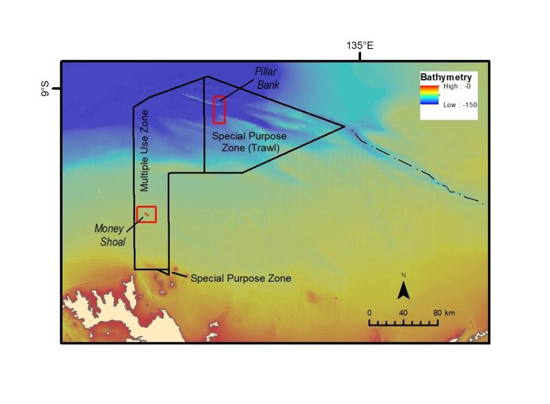
Arafura Marine Park is characterised by a gently sloping broad shelf across the southern part of the park (Multiple Use Zone) that grades to a series of canyons (Arafura canyons) that connect the shelf to the deeper waters of the continental slope, reaching to depths of ~500 m (Special Purpose Zone (Trawl)).
Areas of reef are very limited within the marine park, with Money Shoal the only feature on the continental shelf that supports a shallow water coral reef community.
As an isolated feature, surrounded by an expanse of flat muddy seabed, Money Shoal is unique within the Arafura Sea shelf region. Rising from 60 m water depth to less than 10 m, the reef provides a stable substrate for a diverse assemblage of sponges, hard and soft corals that in turn attract an abundant and diverse population of demersal fish; ranging up to grouper, rays and sharks. In contrast to Pillar Bank, the deeper environments in the northern parts of Arafura Marine Park are characterised by a complex seabed of large and steep ridges, valleys and plains (see a 'fly-through' of the study areas).
Underwater imagery shows these environments are typically highly turbid, due to strong tidal currents, with a sparse seabed biota. These areas are not barren, however, with localised concentrations of filter feeders utilising the rocky outcrop on the steeper parts of ridges. These sites are also observed to support a range of demersal fish. The oceanographic regime of the marine park is characterised by strong tidal flows and a connection to waters delivered by the Indonesian Throughflow and the South Equatorial Current. Nutrient levels are relatively low (oligotrophic) across most of the park, as indicated by low Chlorophyll-a levels on the sea surface. However, closer to the coast, higher nutrient levels occur due to input from rivers; but this is localised.
The satellite record of sea-surface temperatures for the past 15 years shows a relatively stable ocean temperature record across the park. But the region does experience marine heat waves, with three closely spaced events occurring in 2015-2016. While these were classified as ‘moderate’ marine heat waves, the potential for coral bleaching of the shallow water corals on Money Shoal represents a risk to the future health of the reef. The additional impact of physical disturbance by tropical cyclones on Money Shoal emphasises the importance of continued monitoring of this regionally unique ecosystem.
2. Money Shoal
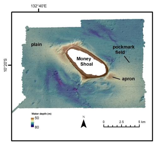
Money Shoal is an oval-shaped reef (6.5 km x 3.3 km) surrounded by a mostly flat sediment plain (see left). The base of the reef sits in ~60 m water depth and rises on a gradient of 10 degrees to ~3 m water depth on the reef platform. Gently sloping aprons of sediment extend up to 1.5 km from the northwest and southeast sides of the reef that are interpreted as the result of re-deposition of suspended sediments. The sediment plains around Money Shoal range in depth from 70 – 80 m and are mostly flat with localised small depressions and channels. Seabed sediments on the plains comprise a mix of mud and carbonate sand and gravel, with higher concentrations of sand near the base of Money Shoal. The plains are also characterised by extensive fields of small pockmarks that form holes less than 1 m deep and 10 - 20 m wide.
2a. Fish and sharks at Money Shoal
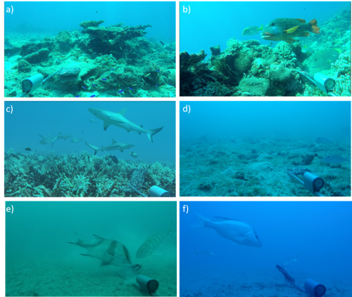
Examples of fish assemblages and associated habitat recorded in the stereo-BRUV survey are shown to the left: a-c on the slopes of Money Shoal, d-f on the surrounding shelf. a) Neon damselfish (Pomacentrus coelestis), Shoulder-spot wrasse (Leptojulis cyanopleura); b) Orangefin emperor (Lethrinus erythracanthus), Blubberlip snapper (Lutjanus rivulatus), Yellowtail emperor (Lethrinus atkinsoni); c) Grey reef shark (Carcharhinus amblyrhynchos); d) Bridled triggerfish (Sufflamen fraenatum), Drab emperor (Lethrinus ravus); e) Red emperor (Lutjanus sebae), Goldband snapper (Pristipomoides multidens); f) Saddletail snapper (Lutjanus malabaricus), Crescent grunter (Terapon jarbua).
Commercially important saddletail snapper (Lutjanus malabaricus), red eared emperor (Lethrinus lentjan) and gold band snapper (Pristipomoides multidens) were seen off Money Shoal in areas where pock marks provide topographic relief and fish habitat in the soft substrate.
Grey reef sharks (Carcharhinus amblyrhynchos) patrol over rich coral habitats on the shallow edges of Money Shoal.
Rich coral habitats in clear shallow water support a highly diverse fish community. Among the larger species here are giant Queensland groper (Epinephelus lanceolatus) and flowery rockcod (Epinephelus fuscoguttatus).
The commercially important red emperor (Lutjanus sebae) and gold band snapper (Pristipomoides multidens) are characteristic of deeper off shoal sedimentary habitats.
The deeper waters where the shoal transitions to soft sediment habitat are characterised by rubble and small outcrops of hard substrate supporting filter feeding benthic communities and moderate fish diversity.
A diverse and colourful assemblage of coral reef-associated fishes can be seen in the shallow areas of Money Shoal dominated by hard corals.
2b. Benthic communities at Money Shoal
A diverse range of benthic communities were observed at Money Shoal (see below), dominated by algae (57.58%) but also including: hard coral (3.19%), sponges (1.67%), octocorals (1.59%), Holothuria (0.01%) and seagrass (0.01%). Foraminifera and burrowers were seen in the images but their cover could not be measured accurately.
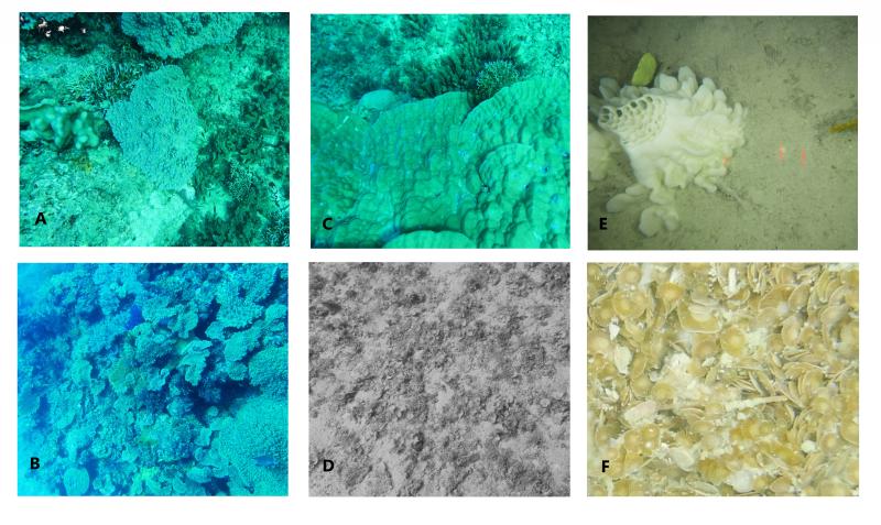
A - Hard and soft coral and macroalgae (Caulerpa sp) at 11.5 m depth; B - Hard and soft corals at 11.9 m depth; C - Hard coral and macroalgae at 12 m depth; D - macroalgae (Padina sp) at 23.5 m depth; E - Sponge and Soft coral at 67.9 m depth; F - Large benthic foraminifera observed throughout the study area.
Note that mean hard coral cover measured in our study area was low (3.19%) compared to other oceanic Shoals of comparable size in the northwest and northern Australia. However this is no doubt an underestimate because we were unable to survey across the top of the shoal in water shallower than 7.5 m. Most hard corals were found in shallow water depths (7.5 - 22 m). Indeed, the average coral cover for Arafura Marine Park recorded at two reefs in shallow waters only by Reef Life Survey was around 25%.
Below are two examples of towed video transects along the shallower parts (~12 m depth) of Money Shoal.
3. Acknowledgement
The Yuwurrumu members of the Mandilarri-Ildugij, the Mangalara, the Murran, the Gadura-Minaga and the Ngaynjaharr clans have responsibilities for sea country in the marine park, which they have been sustainably using and managing for tens of thousands of years.