
Datasets for: NERP TE Project 9.4 - Conservation planning for a changing coastal zone (JCU)
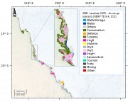
This dataset consists of different possible land use configurations along the Great Barrier Reef coastal zone for the future (year 2035) under eight different scenarios (plausible futures). Scenarios are not predictions and do not intend to show what the coastal zone will look like (this is impossible as the future of coastal development I highly uncertain, even on a short term basis, let alone 25 years). Instead, scenarios are used to depict some plausible futures under certain circumstances so that managers can understand the system better and the various ways the future might unfold.
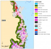
This dataset consist of inputs and intermediate results from the coastal scenario modelling. It is an analysis of the bio-physical factors that best explain the changes in QLUMP land use change between 1999 and 2009 along the Queensland coastal region for the classifications used in the future coastal modelling.
Methods:
The input layers (variables etc) were produced using a range of sources as shown in Table 1. Source datasets were edited to produce raster dataset at 50m resolution and reclassified to suit the needs for the analysis.
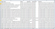
This dataset corresponds to a database of datasets that are relevant for the development of coastal development scenarios and impact assessments GBR. It corresponds to a list of all the datasets that were sourced as part of project 9.4. It contains basic information about each dataset along with the license that each dataset was obtained under and where the data can be sourced. This database is an excellent starting point for any others looking at obtaining data relevant for coastal management.
Methods:

The values of the Great Barrier Reef World Heritage Area (GBRWHA) are threatened by coastal development through habitat loss and runoff of sediment, nutrients and pollutants. Future coastal development is difficult to predict because it depends on volatile socio-economic and political factors. With this in mind, we developed a research project that uses spatially explicit scenario planning to identify plausible futures to 2035 for the GBRWHA coastal zone. The method used to produce maps of these scenarios is land-use change modelling using the GIS Idrisi.
This dataset corresponds to the polygon digitisation of tourism sites and sugar mills. The locations of the tourism sites were obtained from a commercial database of tourism operators (Australian Tourism Warehouse). The location of sugar mills was obtained from information gathered on the internet and point locations were created for each mill. These datasets were developed to fill in missing source datasets for the scenario modelling used for the coastal development modelling.
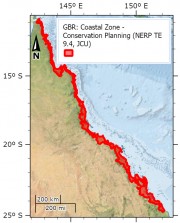
This dataset contains the extent of the coastal zone for the Great Barrier Reef. This extent was identified as the most suitable area to be investigated on land and at sea as part of a conservation planning project looking at coastal development along the GBR coast.
Methods: