
Where
Who
Jody Webster (University of Sydney) and Robin Beaman (James Cook University)
When
July 2007
Why
Mapping the seafloor allows us to build a picture of what lies beneath our vast oceans. These maps are useful in determining the depth (bathymetry) of the seafloor, and discovering important seafloor features and habitats.
How?
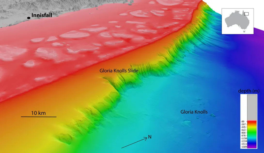
High resolution multibeam mapping of the seafloor 75 kilometres off the north coast of Queensland revealed a debris field of massive blocks (up to 100 metres high and 3 kilometres long). To further investigate the origin on these blocks, seismic profiles were used to look at the subsurface geology, and rock dredge samples were collected to look at the composition and age, as well as record any biotic communities that might exist on the hard substrate these blocks provide.
Description
A north-westerly view of the Gloria Knolls slide off Innisfail. Depths are coloured red (shallow) to blue (deep), over a depth range of about 1700 metres.
What did we learn?
Now known as the Gloria Knolls, seismic profiles have confirmed that these blocks are the leftovers from an underwater landslide on the continental slope more than 300,000 years ago. The Gloria Knolls landslide was a huge event, and multibeam mapping showed the landslide scarp (scar) is 8 kilometres wide, 20 kilometres long and stretches the entire slope height, from 200–1000 metres deep. The knolls lie scattered in the Coral Sea, 30 kilometres away from the main landslide scarp, in depths of 1300 metres. Knowledge of the Gloria Knolls and their source on the continental slope has helped us to understand the evolution of the north-eastern Australia margin and the role that erosion has in influencing deep seafloor habitats. A rock dredge taken from one of the knolls also revealed evidence of a coldwater coral community, which is able to exist in this location due to the patchy hard rocky surfaces this knoll provides. This discovery has implications on the role of landslides in forming deep-sea coral communities.

Description
The Gloria Knolls landslide - a westerly view of the Gloria Knolls lying in the Queensland Trough downslope of the Gloria Knolls Slide. Depths are coloured red (shallow) to blue (deep), over a depth range of about 1500 metres.
What next?
Mapping of the Coral Sea Marine Park will help inform marine park managers on the location of key seabed features, and where to undertake more detailed research and monitoring in the future. The information these maps provide on depth and topography (shape and elevation) is also useful in fisheries and natural hazard management, and geological, oceanographic, and biological research.
Related data and publications
- Puga-Bernabéu, Á., Beaman, R.J., Webster, J.M., Thomas, A.L., Jaconsen, G. (2017) Gloria Knolls Slide: A prominent submarine landslide complex on the Great Berrier reef margin of north-eastern Australia. Marine Geology 385, 68-83.
- ABC News - Researchers discover underwater landslide '30 times the volume of Uluru' on the Great Barrier Reef
- Undersea landslides of north-eastern Australia - deepreef.org project summary.
- Beaman, R.J. & Webster J.M. (2008) Gloria Knolls: a new coldwater coral habitat on the Great Barrier Reef margin in Neil H., & Tracey, D. (Editors), 4th International Symposium on Deep-Sea Corals, 1-5 December 2008. National Institute of Water and Atmospheric Research, Wellington, New Zealand.
- Webster J.M., Beaman, R.J., Bridge, T., Davies, P.J., Byrne, M., Williams, S., Manning, P., Pizarro, O., Thornborough, K., Woolsey, E., Thomas, A. Tudhope, S. (2008) From corals to canyons: The Great Barrier Reef margin EOS, Transactions, American Geophysical Union 89(24), 217:218. doi: 10.1029/2008EO240002
For more information please contact marinescience@environment.gov.au.