This study investigated the influence of Great Barrier Reef Marine Park Zoning on fish abundance of the Great Barrier Reef. The fish populations of pairs of shoals, one in a Green zone (closed to fishing) and the other in a Blue (open to all fishing) were compared using Baited Remote Underwater Video Stations (BRUVS).
These BRUVS revealed a diverse fauna of fish, sharks, rays and sea snakes, including species prized by fishers, taken as bycatch, or not vulnerable to hook and line fishing.
As part of this project 162 videos from 48 study locations, were uploaded to Youtube and made accessible through the KMLs provided below. These videos show the 30 sec from the 1 hour of footage that contained the highest density of Coral Trout and Red Emperor. The KMLs show a map of the fish counts at each of the study locations along with associated videos and swathmaps.
- View all 162 videos on youtube uploaded as part of this project.
- Online Google Earth KMZ [800 kB]. Videos are viewed from YouTube.
- Offline Google Earth KML [310 MB zip]. Includes all videos (MPEG4 format) and swathmaps. Unzip and check the README.txt.
- Great Barrier Reef Marine Park Zoning 2003 [KMZ 1.3 MB]. This dataset is useful for comparison. The e-Atlas page for this dataset.
Description
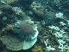
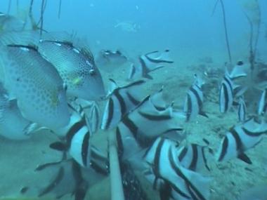
Abundant coral trout (Plectropomus leopardus) and other reef fish species
Description
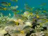
Numerous juvenile red emperor (Lutjanus sebae), as well as starry trigger fish (Abalistes stellatus)
Description
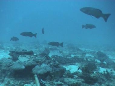
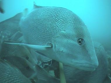
Red emperor (Lutjanus sebae)
Introduction
During the extensive community consultation that accompanied the rezoning of the Great Barrier Reef Marine Park in 2004, anecdotal information emerged about the importance of submerged “shoals” and low-relief seabed features as intensified targets for commercial and recreational fishing.
In the offshore domain, there was evidence of effort shift in the commercial fishery for live coral trout from shallow reef flanks to deeper inter-reefal shoals because of the more valuable red colour of coral trout living at depth. In the coastal zone, there was evidence of effort shift in the recreational fishery from shallow reefs to deeper waters away from the immediate vicinity of emergent and island fringing reefs.
While part of this shift in effort may have been in response to the high fishing pressure placed upon accessible and popular reefs, technology creep (such as affordable colour echo sounders and GPS units) has allowed recreational fishers to find and return to small habitat features supporting alternative species. This appears to be a major driver for increased interest in the prized lutjanid red snappers (red emperor, small- and large-mouth nannygais). Fisheries managers are not well equipped to deal with this shift in fishing effort in either domain because there is almost no information about the distribution and nature of these submerged seabed habitats and their biology (see Mapleston et al., 2006).
A four year campaign of research was conducted to describe these unknown seabed features in different regions, develop baseline counts of fish there, and use “pair-wise” comparisons of shoals open and closed to fishing since 2004 to assess any changes evident since rezoning.
Description
Two large-mouth nannygai (lutjanus malabaricus).
Description
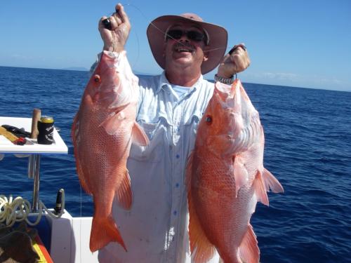
Mixed catch from deep shoals of tropical snappers (Lutjanus and Pristipomoides species), coral trout (Plectropomus leopardus), trevallies (Carangoides chrysophrys), Tuskfish (Choerodon venustus), spangled emperor (Lethrinus nebulosus) and Spanish mackerel (Scomberomorus commerson). Photo: Martin Brennan
Overview of Results
In the first year of this task, AIMS searched the seafloor in the vicinity of Cairns, Cardwell, Townsville, the Whitsundays, Rockhampton, and Gladstone using a multibeam acoustic swathe mapper, ground-truthed by towed video, to develop baselines in comparable “pairs” of fished (“blue”) and unfished (“green”) submerged shoals. The fish populations on these shoals were then sampled with baited remote underwater video stations [BRUVS] because the habitats of interest were below diving depth (i.e. >20 m) (Speare and Cappo, 2006; Speare and Stowar, 2007).
In the second year, the core sites (Cardwell, Townsville) were re-sampled with only partial success due to the exceptional wet season of 2007/08 (Speare and Stowar 2008). On the advice of GBRMPA, Cairns shoals were abandoned because of uncertainty about the level of fishing effort there. Southern shoals (Barcoo and Karamea Banks; East and West Warregoes) were sampled intensely in order to recommend an optimal strategy for sampling large, discrete, submerged shoals. Although there were some mixed results, these large shoals showed differences in the abundance of a dozen key “target” species consistent with an effect of fishing detectable since the rezoning (blue to green) of one shoal from each pair in July 2004 (Speare and Stowar, 2008; Stowar et al., 2008). There was also evidence from pilot stereo-video measurements that target species might be bigger around the southern banks closed to fishing (Johansson et al., 2008).
In contrast, the low relief shoals in the vicinity of Townsville known as the Magnetic Shoals did not show any impact from the rezoning -- despite the likelihood of good enforcement resulting in substantial differences in fishing effort on blue and green shoals (Speare et al., 2008). We believed that this was because the low-relief habitat was only a transient habitat for the large “target” species and that the mobility of these species soon exposed them to fishing.
In the third year, we used our proven ability to assess fish abundance in deep water to investigate the abundance of fish species vulnerable to line fishing around the bases of reefs where there was evidence of strong fishing effects. We focussed on the three southern regions (Pompeys, Swains and Capricorn-Bunker Groups) where there was evidence of a sustained and growing impact of fishing upon the coral trout populations in shallow water (Russ et al., 2008).
Our focus in the third year remained on deep water coral trout, emperors, snappers, cods and tuskfish. BRUVS were used to sample fish abundance in deep (~45-60 m) water around 16 “blue/green” reef pairs where diver surveys had shown either weak or strong contrasts in coral trout abundance in shallow water (Cappo et al., 2009a).
Our second major objective in that year was “desktop” work to refine the use of baited video techniques to establish definitive methods to detect differences in fish abundance and length compositions amongst “green” and “blue” reefs (Cappo et al., 2009b). Those desktop studies showed almost 100% of the variation amongst tapes was due to the location of collection of the tape for the major study species – not the expertise of the reader or the time of reading. Secondly, smaller individuals of economically important species were shown to be visiting the BRUVS earlier than bigger ones, and we developed a measurement protocol to obtain the optimal length compositions to represent zoning effects. Such effects were detected, with more bigger, and more smaller, red emperor around the deep bases of “green” shoals, and more coral trout and venus tusk fish above the legal minimum size around the same banks. In contrast, the unfished “controls” showed no such difference in the shape of the length compositions (Cappo et al., 2009b).
During the final year of field work in 2009/2010, we aimed to complete the “shoals” study by re-sampling and tying the various components together (see Cappo et al. 2010). We tested if the “effect of fishing” signals detected in year 2 for deepwater sweetlips (Lethrinus miniatus), snappers (Lutjanus spp), cods (eg Plectropomus leopardus, Epinephelus undulatostriatus) and tusk fish (Choerodon venustus) were more, or less, perceptible since the 2004 RAP zoning. The abundant starry triggerfish (Abalistes stellatus) and collared sea bream (Gymnocranius audleyi) were analysed as unfished “controls” to ensure comparability in habitats. We also provided coarse regional comparisons of these results with “snapshots” of mean abundances from shoal pairs in five other regions obtained during the four years of this project.
Within each pair, one shoal was zoned “green” (closed to fishing) and the other “blue” or “yellow” (open to line fishing). The demersal habitats and vertebrate communities were sampled using non-extractive Baited Remote Underwater Video Stations (BRUVS), which revealed a diverse fauna of fish, sharks, rays and sea snakes, including species prized by fishers, taken as bycatch, or not vulnerable to hook and line fishing.
Non-linear mixed-effects models were used to estimate the influence of zoning on the maximum number of fish observed by each BRUVS (MaxN) for specific components of the fish community. Sampling year and shoal pair, or region of the GBRMP, were used as random factors in testing the (fixed) effect of zone. Interquantile distances around median counts of fish were also used to assess the significance of these factors in explaining the MaxN of species groups.
The most parsimonious model generally showed that year was not significant, but zone and pair were. This was because the change with increasing time of closure to fishing was inconsistent, with the gap widening between “green” and “blue” for one pair of southern banks but not the other. This apparent interaction between year and pair was not statistically significant, with ratios between banks open or closed to fishing averaging about 1.8 to 2.6 for “prized” and “target” species.
Comparisons of global means, with no accounting for differences in type of substratum or habitat type, showed the effects of zoning were not consistent amongst regions and species groups. The Cairns and Pompeys reef bases showed more target fish in “green” zones, but the Swains and Capricorn-Bunkers reef bases had less. The diffuse Townsville shoals had less target and bycatch species in “green” zones, whilst the nearby, discrete, Cardwell shoals showed very high ratios of ~5 to ~17 for target groups between “closed” and “open” fishing zones.
The use of a novel stereo-video technique enabled us to show precisely and accurately that more, larger “target” species were accumulating on southern banks closed to fishing. There was a larger proportion of larger coral trout, red emperor, red-throat emperor and Venus tuskfish in the shoals closed to fishing, far above the legal minimum size at first capture. In contrast, the “unfished” starry triggerfish and collared sea bream showed no major displacement amongst modes between zones.
A number of explanations can be invoked for the different patterns and regions. Fish can move between zones, political influences near townships may have led to closure of “poorer” shoals, and there may be very low levels of fishing effort (within the bounds of natural disturbances) in remote areas such as the Swains. We had no access to useful statistics on fishing effort on the shoals, and levels of poaching were unknown. It was also possible that some “green” shoals in our pairwise comparisons were always better habitats and had always supported more fish than those open to fishing before the rezoning in 2004.
However, this project has clearly demonstrated that numbers and biomass do accumulate (through more, larger fish) in submerged shoal habitat in green zones. The lack of a consistent trend amongst regions, pairs of shoals, species groups, and individual species, should not be cited as some sort of failure of management or science – nor should each shoal be treated as a “special case”. Rather, the limits to pairwise comparisons of “shoals” should be recognized and incorporated into future research questions.
References
- Cappo MC, MacNeil MA, Stowar MJ and Doherty PJ (2009a) The influence of zoning (closure to fishing) on fish communities of the deep shoals and reef bases of the southern Great Barrier Reef. Part 1 - Baited video surveys of the Pompey, Swain and Capricorn-Bunker groups of reefs off Mackay and Gladstone. MTSRF Research Report No. 37 ISBN 9781921359361. Reef and Rainforest Research Centre and Australian Institute of Marine Science. 53 p. PDF Link to abstract/full text View Details
View metadata record - Cappo MC, De'ath AG, Stowar MJ, Johansson C and Doherty PJ (2009b) The influence of zoning (closure to fishing) on fish communities of the deep shoals and reef bases of the southern Great Barrier Reef. Part 2 - Development of protocols to improve accuracy in baited video techniques used to detect effects of zoning. MTSRF Research Report No. 38 ISBN 9781921359378. Reef and Rainforest Research Centre and Australian Institute of Marine Science. 44 p.
- Cappo MC, Stowar MJ, and MacNeil MA (2010) The influence of zoning (closure to fishing) on fish communities of the shoals and reef bases of the Great Barrier Reef Marine Park. Results of repeated surveys of the southern banks and Cardwell shoals, and an overview with regional comparisons. Final Report to RRRC on MTSRF Project 4.8.2. June 2010. 60 pp.
- Mapleston A, Begg GA, Ballagh A, Goldman B, and Williams AJ (2006) Monitoring the effects of re-zoning on non-reef habitats of the Great Barrier Reef: Identifying locations and harvested species of interest. Report to CRC Reef, 49 pp.
- Russ GR, Cheal AJ, Dolman AM, Emslie MJ, Evans RD, Miller I, Sweatman H, Williamson DH (2008) Rapid increase in fish numbers follows creation of the world’s largest marine reserve network. Current Biology 18(12) R514-R515.
- Speare PJ and Cappo MC (2006) Fish populations on Inshore Shoals: A pilot study and lessons for monitoring the effects of zoning in the Great Barrier Reef Marine Park. Report to the Australian Government Department of Environment and Heritage. Australian Institute of Marine Science. 32 p.
- Speare PJ and Stowar MJ (2007) Preliminary findings from the first baseline survey of the Magnetic Shoals.Project Progress Report. Reef and Rainforest Research Centre. 26 p. PDF Link to abstract/full text View Details
- Speare PJ and Stowar MJ (2008) A comparative study between fished and protected inter-reefal shoal habitats and their fish communities on the Great Barrier Reef. Report on ongoing monitoring off Townsville and initial surveys near Cardwell and Cairns, north Queensland. MTSRF Research Report No. 6 ISBN 9781921359057. Reef and Rainforest Research Centre and Australian Institute of Marine Science. 60 p. PDF Link to abstract/full text View Details
- Speare PJ, Stowar MJ and Johansson C (2008) Temporal monitoring of northern shoals off Cardwell and Townsville. Report to the Marine and Tropical Sciences Research Facility. Reef and Rainforest Research Centre. 40 p. PDF Link to abstract/full text View Details
View metadata record - Stowar MJ, De'ath AG, Doherty PJ, Johansson C, Speare PJ and Venables W (2008) Influence of zoning on midshelf shoals from the southern Great Barrier Reef. Report to the Marine and Tropical Sciences Research Facility. Reef and Rainforest Research Centre and Australian Institute of Marine Science. 90 p.
PDF Link to abstract/full text View Details
View metadata record
Notes
The processing of the BRUVS dataset was performed as part of the MTSRF Project 4.8.2.
Related content