 eAtlas Data Catalogue
Landsat
Type of resources
Topics
Keywords
Contact for the resource
Provided by
Years
Representation types
Update frequencies
status
-
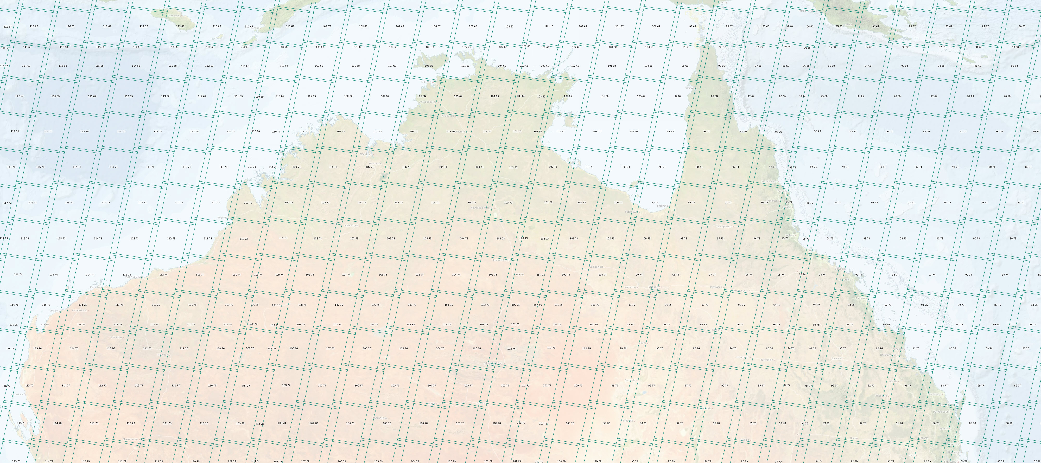
This dataset shows the tiling grid and their Row and Path IDs for Landsat 4 - 9 satellite imagery. The IDs are useful for selecting imagery of an area of interest. Landsat 4 - 9 are a series of Earth observation satellites, part of the US Landsat program aimed at monitoring Earth's land surfaces since 1982. The Worldwide Reference System (WRS) is a global notation system used for cataloging and indexing Landsat imagery. It employs a grid-based system consisting of path and row numbers, where the path indicates the longitude and the row indicates the latitude, allowing users to easily locate and identify specific scenes covering a particular area on Earth. Landsat satellites 4,5,7, 8, and 9 follow WRS-2 which this dataset describes. This dataset corresponds to the descending Path Row identifiers as these correspond to day time scenes. eAtlas Notes: It should be noted that the extent boundaries of the scene polygons in this dataset are only indicative of the imagery extent. For Landsat 5 images the individual images move around by about 10 km and the shape of the Landsat 8 and 9 images do not match the shape of the WRS-2 polygons. The angle of the top and bottom edges are at a different angle to the imagery, where the imagery is more square in shape. The left and right edges of the polygons are also smaller than the imagery. As a result of this, this dataset is probably not suitable as a clipping mask for the imagery for these satellites. This dataset is suitable for determining the approximate extent of the imagery and the associated Row and Path IDs for a given scene. Why is this dataset in the eAtlas?: Landsat imagery is very useful for the studying and mapping of reef systems. Selecting imagery for study often requires knowing the Path and Row numbers for the area of interest. This dataset is intended as a reference layer. This metadata is included to link to from the associated mapping layer. The eAtlas is not the custodian of this dataset and copies of the data should be obtained from the original sources. The eAtlas does however keep a cached version of the dataset from the time this dataset was setup to make available should the original dataset no longer become available. eAtlas Processing: The original data was sourced from USGS (See links). No modifications to the underlying data were performed. Location of the data: This dataset is filed in the eAtlas enduring data repository at: data\\non-custodian\2020-2024\World_USGS_Landsat-WRS-2