Seagrass meadow boundaries 1984 - 2014 (NESP 3.1, JCU)
GBR: Seagrass site surveys 1984-2018 (NESP 3.2.1 and NESP 5.4, JCU)
This map shows the extent of the seagrass meadows on the Great Barrier Reef based on surveys conducted from 1984 - 2018. These observations were collected using a range of survey methods (video transects, van Veen grab, free diving, helicopter and walking). More details about these methods are described in the dataset metadata: Seagrass mapping synthesis: A resource for coastal management in the Great Barrier Reef (NESP TWQ Project 3.2.1 and 5.4, TropWATER, James Cook University)
Seagrass meadows change over time with the seasons and in response to environmental conditions such as light levels and physical damage from cyclones. This map does not capture this variation over time and thus only represents the approximate extent of where seagrass might be found.
If you expand the interactive map by clicking the ![]() button there are two extra layers that you can turn on showing the results of modelling the distribution of seagrasses in the wet and dry seasons.
button there are two extra layers that you can turn on showing the results of modelling the distribution of seagrasses in the wet and dry seasons.
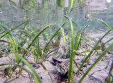
Seagrasses are unique in the marine environment in that like many land plants they reproduce by flowering and producing seeds. They are however also capable of asexual reproduction through horizontal rhizome growth. Seagrass meadows consist of a nested structure of clones, that sometimes fragment into individual plants. Meadows may appear static however the extent and density of the seagrass is highly dynamic.[2]
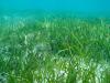
The name seagrass probably originated because some species look like grasses and form lawn-like meadows that resemble grasslands. There are around 17 species in Queensland that vary from the size of your fingernail to those with long strap like leaves and 11 species known from Torres Strait [1]. Different seagrass species have different tolerances to light and temperature and vary in their sensitivity to changes in environmental conditions
The seagrass ecosystems are of national significance due their role in sustaining fisheries and as a food source for the endangered marine mammal, the dugong.
Shallow water seagrasses are most common in sheltered areas where sediments accumulate.
See the Seagrass in Torres Strait article for more information about seagrasses.
References
- Carter, A. B., McKenna, S. A., Rasheed, M. A., McKenzie L, Coles R. G. (2016) Seagrass mapping synthesis: A resource for coastal management in the Great Barrier Reef World Heritage Area. Report to the National Environmental Science Programme. Reef and Rainforest Research Centre Limited, Cairns (22 pp). Available at https://nesptropical.edu.au/wp-content/uploads/2016/03/NESP-TWQ-3.1-FINAL-REPORT.pdf
- Collier, C. J., A. B. Carter, M. A. Rasheed, L. McKenzie, J. Udy, R. Coles, J. Brodie, M. Waycott, K. R. O’Brien, M. Saunders, M. Adams, K. Martin, C. Honchin, C. Petus, and E. Lawrence. 2020. An evidence-based approach for setting desired state in a complex Great Barrier Reef seagrass ecosystem: A case study from Cleveland Bay. Environmental and Sustainability Indicators 7: 100042.
- Lambert, V., Collier, C., Brodie, J., Adams, M.P., Baird, M., Bainbridge, Z., Carter, A., Lewis, S., Rasheed, M., Saunders, M., O’Brien, K., (2020) Connecting Sediment Load Targets to Ecological Outcomes for Seagrass. Report to the National Environmental Science Program. Reef and Rainforest Research Centre Limited, Cairns (140pp.).
- Lambert, V. M., M. P. Adams, C. Collier, A. Carter, M. Saunders, J. Brodie, Z. T. Bainbridge, M. Rasheed, R. E. Turner, and K. R. O’Brien. 2019. Towards ecologically relevant targets: impact of flow and sediment discharge on seagrass communities in the Great Barrier Reef. 23rd International Congress on Modelling and Simulation. Canberra, ACT, Australia.