Seagrass in Torres Strait

The Torres Strait lies to the north and north-east of Cape York and separates Australia and Papua New Guinea. It is about 90 nautical miles wide and 150 miles long. A characteristic feature of Torres Strait is large expanses of shallow seas that support productive coastal marine ecosystems, including abundant seagrass/algal meadows and coral reefs. Throughout Torres Strait, the sea is the centre of island culture and industry and the continued health of coastal ecosystems is of vital importance. Within shallow coastal marine ecosystems, seagrass habitats are considered of high value [1], but also among the most threatened [2]. Seagrass health is of particular significance because of the diverse roles seagrasses have in sustaining coastal marine ecosystems within Torres Strait.
Seagrasses are unique in the marine environment in that like many land plants they reproduce by flowering and producing seeds. The name seagrass probably originated because some species look like grasses and form lawn-like meadows that resemble grasslands. There are around 17 species in Queensland that vary from the size of your fingernail to those with long strap like leaves and 11 species known from Torres Strait [3]. Different seagrass species have different tolerances to light and temperature and vary in their sensitivity to changes in environmental conditions, including those associated with port and shipping activity [4].
In Torres Strait seagrass is abundant and widespread. The seagrass ecosystems are of national significance due their large size, their role in sustaining fisheries and as a food source for the endangered marine mammal, the dugong. Prior to the start of baseline surveys in 2002 there was a lack of detailed information on abundance and species present in both intertidal and subtidal areas. With surveys continuing to 2013, seagrass communities have now been mapped and quantified for many of the islands, reefs and for the dugong sanctuary to the west of Cape York, established in 1985 (e.g. see Carter et al 2013 [5]). The surveys created a baseline to assess future changes and to predict how changes in seagrass will affect dugong, turtles and fisheries.
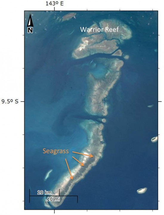
Seagrasses are most common in shallow water where sediments accumulate and in Torres Strait are widespread and abundant in areas to the from the Warrior Reef complex eastward [6]. Seagrasses are vital to the health of Torres Strait coasts as they able to trap and stabilise fine sediments, preventing coastal erosion and are efficient at harvesting nutrients. Much of Torres Strait is shallow with strong tidal currents. Without seagrass, tidal currents would be continually moving sediments around and the habitat most important for juvenile prawns, fish and thousands of animals that live in the sediment would be unstable and less abundant. Recent studies have suggested the ability to trap fine sediments and rapid growth of seagrass may create potential for future economic benefit from carbon farming, an emerging resource in the global economy [7]. Seagrass is potentially valuable for capturing and storing carbon because the sediments are trapped and stabilised over very long time frames and therefore the carbon is not released back into the atmosphere (MacReadie ABC RN radio).
Seagrass is a major food source for turtles and dugong, a marine mammal of cultural and dietary significance within the region. Dugong are an endangered species globally but are abundant locally, with the largest population of dugongs in the world resident in Torres Strait [9,10] (eAtlas). When the dugong sanctuary was established in 1985 little was known of the seagrass community and what food sources were present for the dugong and turtles. Research has shown there is a strong relationship between seagrass and dugong abundance in the sanctuary and that seagrasses of high nutritional value for dugong and turtles such as Halophila ovalis are prevalent [6]. This suggests the sanctuary is well placed to protect dugong populations provided environmental conditions remain suitable for seagrass survival and health. A monitoring program for seagrass within the sanctuary has been established to better understand the dynamics of growth and decline. Baseline surveys found in seagrass in 73% of the sites to a depth of 30 meters. Species sensitive to low levels were found at depth: an indication that conditions for seagrass growth were good within the sanctuary at the time of survey [11].
This map shows the extent of the dugong sanctuary, Dugong relative density (1987-2013 JCU, NERP-TE 2.1), and the extent of seagrass_meadows within the dugong sanctuary from surveys in March 2010 (QDPI). Click on the four arrow square to access the mapping system and associated metadata.
There are many factors that can lead to declines in seagrass including climate events, herbivory and physical disturbance from storms or shipping accidents. One of the most important direct causes of seagrass death is persistent low light. Light penetration through the water to the seagrass on the seabed is vitally important for seagrass health as like land plants, seagrass harvest the sun’s energy to grow. In the absence of light they can survive for some time using stored energy but persistent low light can result in decline. (Collier NERP 5.3). Typically, low light conditions occur due to turbidity, where suspended sediments or tiny plankton in the water reduce light penetration.
Torres Strait has been described as an area of persistent high turbidity. Resuspension of sediments by strong tidal currents is the main cause of turbidity in Torres Strait. During the monsoon fine sediments are transported from the Gulf of Carpentaria and there are periodic exposures to river runoff from the Fly River in Papua New Guinea [18]. Human activity such as dredging and shipping can cause persistent high turbidity in high use areas. Sediments derived from river runoff or dredging can create cumulative stress to seagrass in addition to reduced light as a result of exposure to toxins and pollutants. Historically there have been several widespread episodes of seagrass “dieback” in Torres Strait. Exposure to low light from high turbidity, toxins from mining in PNG, ship groundings, or changes to regional circulation patterns and overgrazing by dugongs have been proposed as likely causes [12]. The causes of “diebacks” are still uncertain but research to date suggests local conditions are the most significant in determining water quality rather than sediments transported from PNG [12]. As such understanding the dynamics of water quality and seagrass populations within Torres Strait is of high importance and requires ongoing research.
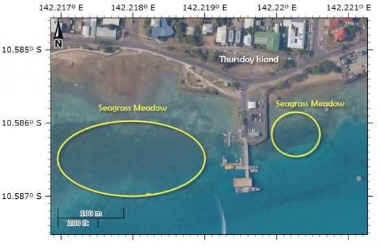
A significant location for seagrass in Torres Strait is around Thursday Island harbour, where regular measurements are taken in order to understand natural variations and to monitor port and shipping activity [13]. The results of the February 2012 monitoring survey found that conditions for seagrass growth have been favourable. Two thirds of the meadows increased in biomass by over 100% and overall biomass was the highest since 2004 [13].
Toxins such as chemicals from agriculture, mining or urban development can be carried into coastal waters from the land, or originate from shipping accidents. Torres Strait became a Particularly Sensitive Sea Area in 2005 in recognition of the need for special protection for the region. As a result the pilotage system on the Great Barrier Reefs was extended to Torres Strait and a new two way shipping channel was established. There are now two major shipping routes that carry cargo ships, bulk carriers and oil tankers through Torres Strait. One route enters Torres Strait from the Queensland coast (the Prince of Wales (PoW) and Adolphus Channel) and the other from the north east (The Great North East Shipping Channel (GNE)). Both shipping routes are considered as high risk to the marine environment because of the high volume of traffic, the proximity to the islands and reefs and because the channel is complicated to navigate, being shallow with complex tidal streams and currents [14]. An outcome of the baseline surveys around the shipping channels undertaken since 2002 was an assessment of risk for each island that could potentially be exposed to a shipping accident or spill. The “value” or habitat vulnerability of the seagrass and algal community was estimated based on abundance and growth rate. Islands or reefs with moderate to high abundance of slow growing species were designated as high risk. Areas with a high abundance of fast growing species were also categorised as high risk on the basis that these were areas of high habitat quality. By applying the risk matrix, if there is a shipping incident, resources can be prioritised to areas considered most significant as resources for dugong, turtles and other fisheries.
Globally, declines in seagrass populations along tropical coasts are widespread, with runoff from agriculture or urban areas and coastal development identified as the leading threats to seagrass health [2]. In Torres Strait development pressure is much lower than most tropical coasts, creating added significance and value to the seagrass meadows within the region. Surveys up to 2013 have mapped seagrasses and identified areas of high value, where management actions can be prioritised in the event of a shipping incident. While monitoring data to date suggests seagrass communities in Torres Strait are in good condition, they are considered a high risk community if exposed to pollution or toxins. Continued monitoring of seagrasses in Torres Strait will build on the knowledge acquired from the baseline surveys to and improve management options for optimising ecosystem resilience.
References
1. Costanza, Robert, et al. "The value of the world's ecosystem services and natural capital." nature 387.6630 (1997): 253-260.
2. Coles, Robert, Grech, Alana, Rasheed, Michael, and McKenzie, Len (2012) Evaluating risk to seagrasses in the Tropical Indo-Pacific Region. Proceedings of the 12th International Coral Reef Symposium. 12th International Coral Reef Symposium, 9-13 July 2012, Cairns, QLD, Australia, pp. 1-5.
3. Mellors, JE & McKenzie, LJ (2009) Seagrass-Watch: Guidelines for Monitoring Seagrass Habitats. Proceedings of a workshop held on Thursday Island, Torres Strait. March 4-8, 2009 (Seagrass-Watch, Townsville) 58pp.
4. Erftemeijer, PLA & Lewis, RRR (2006), ‘Environmental impacts of dredging on seagrasses: A review’, Marine Pollution Bulletin, vol. 52, pp. 1553-1572.
5. Carter, A., Taylor, H., McKenna, S., and Rasheed M. (2013) Critical Marine Habitats in High Risk Areas - Torres Strait - Seo Reef to Kai-Wareg Reef - 2013 Atlas. Tropwater, James Cook University
6. Sheppard, James K., et al. "Spatial patterns of sub-tidal seagrasses and their tissue nutrients in the Torres Strait, northern Australia: Implications for management." Continental shelf research 28.16 (2008): 2282-2291.
7. Lavery PS, Mateo M-Á, Serrano O, Rozaimi M (2013) Variability in the Carbon Storage of Seagrass Habitats and Its Implications for Global Estimates of Blue Carbon Ecosystem Service. PLoS ONE 8(9): e73748. doi:10.1371/journal.pone.0073748
8. Mac Readie ABC Radio (accessed 19 December, 2013)
9. Marsh, H. Penrose, H. and Eros, C(2003) A future for the dugong. In: Marine Mammals: fisheries, tourism and management issues. CSIRO Publishing, Collingwood, VIC, Australia, pp. 383-399.
10. Marsh, Helene, and Donna Kwan. "Temporal variability in the life history and reproductive biology of female dugongs in Torres Strait: The likely role of sea grass dieback." Continental Shelf Research 28.16 (2008): 2152-2159.
11. Taylor, Helen A., and Michael Rasheed (2010). Torres Strait Dugong Sanctuary Seagrass Baseline Survey. Department of employment, Economic Development and Innovation, 2010.
12. Waterhouse J, Brodie J, Wolanski E, Petus C, Higham W (2013) Hazard assessment for water quality threats to Torres Strait marine waters and ecosystems. TropWater, James Cook University.
13. Davies, JN, McKenna, SA, Rasheed, MA & Taylor HA (2012), ‘Long-term seagrass monitoring in thePort of Thursday Island February 2012’. DAFF Publication (Fisheries Queensland, Northern Fisheries Centre, Cairns), 37 pp.
14. Queensland Transport and the Great Barrier Reef Marine Park Authority (2000). Oil Spill Risk Assessment for the Coastal Waters of Queensland and the Great Barrier Reef Marine Park. Department of Transport (Queensland), 65pp.


