
NERP TE Project 10.1 - SELTMP
CSIRO leads the Social and Economic Long Term Monitoring Program (SELTMP) for the Great Barrier Reef.
SELTMP emerged in response to the growing need for transparency in decision-making where calls were repeatedly made by Great Barrier Reef managers for long term social and economic monitoring. Funding for the design and implementation of a comprehensive social and economic long term monitoring program (SELTMP) for the Great Barrier Reef was secured in mid-2011 for 3.5 years. Phase one was to consider commercial fishing, marine tourism, coastal communities, and national residents (Australians) and phase two was to include Traditional Owners, agricultural industries, mining, and ports and shipping. Currently, we are able to report on the results of phase one, which we currently refer to as the '2013 baseline' dataset representing regional, national and international interests and stakeholders enabling new insights across multiple stakeholder groups.
The Social and Economic Long Term Monitoring Program for the Great Barrier Reef describes conditions of the human dimension of the Great Barrier Reef (Reef) using both existing datasets and primary data, with the potential to describe trends through time. The monitoring of conditions and trends can alert Reef managers and other decisions-makers to changes in the social-ecological system, impacts associated with planned or unplanned interventions, levels of public support, and the social and economic trade-offs associated with decision-making.
The SELTMP is an example of efforts to integrate knowledge of the human dimension with ecological and other knowledge to make "better" decisions about managing resources. Whilst awareness of the need to incorporate people into natural resource management is well established, there are only limited examples of how this has been done at a "whole-of systems" level. In the SELTMP, commercial fishers, marine-based tourism operators, tourists, coastal residents, Australians, Traditional Owners, coastal industries, ports and shipping are each considered. The SELTMP thus represents a comprehensive system-wide dataset representing the current status and condition of the human dimension of the Great Barrier Reef with the potential to simultaneously consider trends, interconnections, conflicts, dependencies and vulnerabilities of different user groups.
The SELTMP also offers an opportunity to understand and monitor the growing threat of human actions on the Reef and its catchment and the corresponding capacity of industries and communities to face a range of challenges such as climate change, environmental degradation, regulatory change and cultural change, and to better support ecosystem resilience.
Method
Our approach to provide end-user-relevant data representing the human dimension of the Great Barrier Reef was to create a strong conceptual structure around the choice of indicators and to ensure that indicators would be well-translated, feed directly into current management processes, and be specific (S), measureable (M), actionable (A), relevant (R) and timely (T) (SMART). Hence we developed a "bottom-up" and "top-down" approach.
As part of the bottom up approach we developed a governance structure comprising a steering committee, a stakeholder and scientific advisory panel, and a series of working groups. The steering committee comprises a small number of leading Reef managers to ensure policy relevance. The scientific and stakeholder advisory panel contains a larger number of senior advisors to increase significance of the program, minimise redundancy and maximize end-user engagement. The operational extension of the model occurs through working groups consisting of technical experts from community, government, research and industry who can advise on the indicators of choice and provide existing data. Importantly, our approach also considered datasets that already existed within the region (such as census data, industry records, government files etc), and attempts were made not to replicate efforts. A major output from the bottom-up approach was a "wish list" of indicators that could adequately represent the human dimension from an end-user viewpoint.
The top-down approach referred to a conceptual scientific model to structure indicator choice and define which indicators on the wish list would be part of the data collection process and which would not. The conceptual model focused on drivers, pressures, states, impacts on and responses of systems (DPSIR) modified for the purposes of the project and is very much based on that used by the Millenium Ecosystem Assessment.
The groups of indicators that are monitored by the SELTMP include (i) use and dependency, (ii) benefits from the Reef (wellbeing) (iii) indirect or contextual variables including the socio-cultural context, demography, science and technology, economics and markets, media and communication, and politics and management and (iv) direct drivers such as coastal development and use. How these groups are linked together is shown below:
Results
We anticipate that SELTMP will collect new data annually. Annual snapshots of the human dimensions of the Reef and learnings will be communicated via the following outputs:
-
The database housed on the current web-page. Each year, the SELTMP web-based database will be updated to reflect the most up-to-date knowledge of the human condition of the region. Through this facility, researchers will be able to access data for research purposes, industry will be able to use data to inform their planning and management, and Reef and regional managers will be able to better understand the complex social and economic environment within which they operate and use the data in their day-to-day decision-making processes. The current database contains survey results from over 8,000 individuals across each of the following user-groups: commercial fishers, tourism operators, tourists, local residents, and Australians. See "Maps and Data" tab.
-
Technical reports. Each year a series of technical reports will be published that reports on conditions for that year based on both primary and secondary data. SELTMP 2011 was the inaugural year in which the design and conceptual model were developed. It assembled and presented data from a range of existing sources relevant to people and industries in the GBR and catchment. SELTMP 2012 was refined in terms of its design and included updated secondary data. SELTMP 2013 was the first year in which data gaps were addressed and primary data collected to add to the secondary data. SELTMP 2014 will include any additional updates from existing datasets. See "People of the Great Barrier Reef" tab.
-
Science papers. Human trends will be analysed and communicated through science papers that showcase the science value and management application of the SELTMP. The SELTMP is currently in its design and implementation phase, and hence has limited longitudinal value at this stage. Science papers in the immediate term will be drawn from the comprehensive baseline dataset for science and policy relevance and value. See below.
-
Communications for industry, government and community. Key findings will be highlighted through annual media campaigns in which communication products such as 'key findings booklets', press-releases, popular media articles, seminars and conferences, will be developed. See "home" tab.
Reports, Publications and News
![]()
For more information see Project 10.1 'Social and Economic Long Term Monitoring Programme (SELTMP)'; on the NERP Tropical Ecosystems Hub site.
Images
Datasets
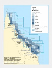
This dataset contains Active Licenses, Effort days, Harvest Weight and GVP for the Queensland commercial harvest, line, net, pot and trawl fisheries. The data is provided on a 30 min grid for locations where there are more than 5 licensed operators.
Commercial fishers and charter fishers are required by law to complete daily logbooks. Commercial fishing logbooks are used to record: overall catch, time spent fishing, location where catch was taken and fishing equipment used. This data is then managed by the Department of Agriculture, Fisheries and Forestry (DAFF).
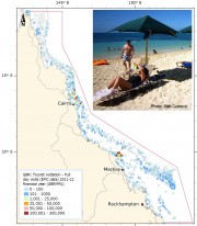
This dataset shows the spatial distribution of the number of visitors to the Great Barrier Reef Marine Park based on visitation rates collected from the Environmental Management Charge (EMC) managed by GBRMPA. The spatial information has been quantised into a 0.1 degree grid size.
This data only represents visitors to the Great Barrier Reef who used commercial tourist operations. Data is collected and updated quarterly following receipt of Environmental Management Charge returns from tourism operators. This dataset is a set of annual snapshots of this monthly data.