Advances in the use of remote sensing technologies and computing power are supercharging remote marine research.
Description
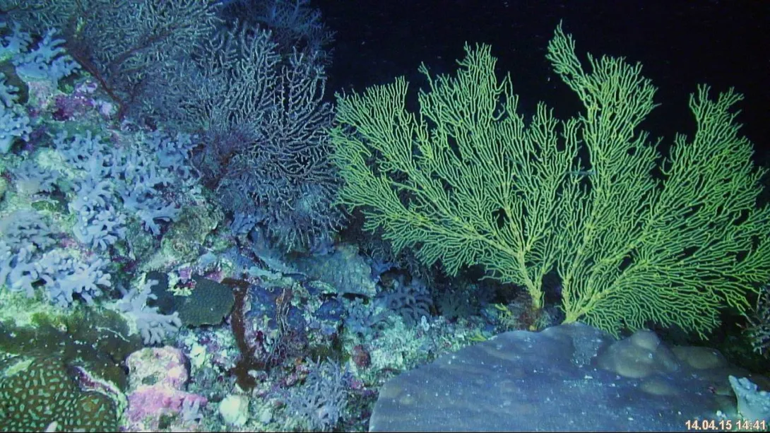
Imagery of the deeper coral communities of Scott Reef collected using the ROV SAAB Sea Eye. (Photo: Schmidt Ocean Institute / Dr Andrew Heyward AIMS)
Marine scientists are exploring one of the most remote and pristine marine regions in Australia, the Timor Sea. The research examined links between ocean circulation and mixing with the benthic biodiversity of these unique and poorly understood coral reefs. With the novel use of a suite of cutting edge remote sensing technologies and a high performance supercomputer on the ship, this is the first time scientists have been able to examine how fine-scale oceanographic processes drive the connectivity and productivity of these reefs in near real time.
Underwater oases
Description
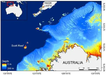
Map of north west Australia highlighting offshore emergent and submerged reefs of the oceanic shoals bioregion. (Image: Dr Cordelia Moore)
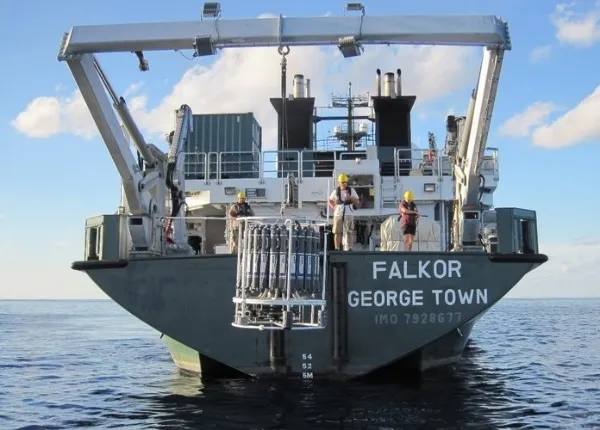
The Timor Sea is located between north western Australia and the island of Timor. Within this region lie some of the planet’s most remote and healthy coral reefs. In places, the biodiversity of these reefs rival that of the better known Great Barrier Reef. A team of scientists from the University of Western Australia, the Australian Institute of Marine Science, Stanford University and Griffith University spent 25 days at sea researching the coral reefs of the Timor Sea on board RV Falkor, a research vessel run by the Schmidt Ocean Institute. The research made use of both ship-based measurements and an extensive instrument mooring array at Scott Reef. The mooring array consisted of more than 50 instruments at 27 separate physical sites over the coral reef/lagoon system and this provided continuous measurements of physical oceanographic conditions during the entire cruise period covering the full spring/neap tidal cycle.
Description
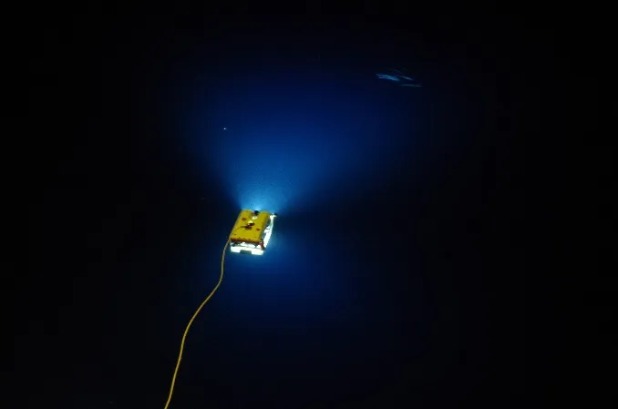
The ROV SAAB Sea Eye sinks beneath the surface for an evening of exploration.
The unique combination of a highly skilled multidisciplinary research team, and leading scientific systems and instrumentation on board, enabled the research team to collect the most comprehensive dynamic and high resolution data for such remote coral reefs. In addition, the Schmidt Ocean Institute has installed a cluster of interconnected high-performance computers, making her the first research vessel with a supercomputing system. Chief scientist Prof Greg Ivey said that “the combination of a multidisciplinary research team, extensive mooring array system, enabling remote sensing technologies and a high performance supercomputer enabled us to model the highly dynamic processes structuring and driving the biodiversity and productivity of these remote coral reefs in near real time. This is unprecedented, particularly in such a remote location.”
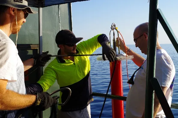
Description
Deploying the CTD rosette for in situ oceanographic measurements. (Photo credit: SOI / Dr Richard Brinkman AIMS)
Having this capacity on board a research vessel operating in these remote reefs, where tides and currents in excess of 1m/s have been detected at depths of 200 metres, means that the models can guide the placement of equipment in order to detect and understand these previously elusive and transitory phenomena. This understanding is critical for identifying the processes responsible for shaping these unique reefs.
A balancing act
The reefs are part of a large group of submerged and emergent features on the western margin of the Oceanic Shoals bioregion. This region also supports a multi-billion dollar oil and gas industry. As these reefs are located above large natural gas reserves, they have been of increasing interest because of their proximity to the 2009 Montara oil spill, and because of plans to station a floating liquefied natural gas (FLNG) processing facility 100 kilometres to the east, which will likely be the world’s largest floating structure. The proposed Commonwealth Marine Reserves, currently under review, offer only some of these reefs additional protection. Therefore, understanding the biodiversity and function of these reefs is critical for their protection and sustainable management.
Dynamic research
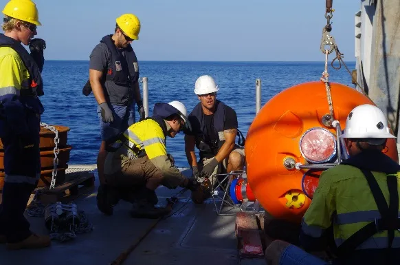
Description
Dr Matt Rayson, David Spencer and Chief Scientist Prof Greg Ivey prepare to deploy instrumentation (TurboMAP) measuring micro-scale oceanographic mixing. (Photo credit: SOI / Dr Cordelia Moore)
Previous research within the region has collected important data on ocean currents and seabed biodiversity, but this is the first time that a wide range of physical oceanographic and biological data has been collected simultaneously with the aim of elucidating process connections. Collecting this simultaneous data over a range of spatial scales is crucial for understanding the dynamics of these systems. The objective was to address a number of key scientific questions. What are the oceanographic processes driving the productivity and connectivity of these reefs? How does the structure and the diversity of these reefs change through time? How often are these reefs exposed to disturbance events and how quickly do they recover? With a multidisciplinary team of oceanographers, biologists, ecologists, spatial scientists and modellers they have been able to utilise and integrate a number of different technologies, in situ, to examine processes controlling the energetics and productivity of the reefs. This is a very novel approach and one that has in the past been limited by a lack of high resolution remote sensing technologies and computing power.
High resolution reef
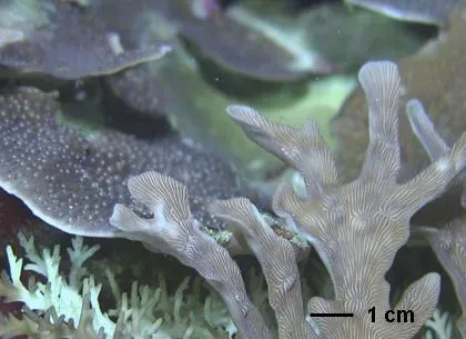
Description
High definition video on the Falkor ROV enable scientists to view individual coral polys at depths of 40 to 60 meters. (Photo credit: SOI / Dr Andrew)
Obtaining high resolution chemical, physical and optical sensing measurements of the reef enabled the scientists to assess the deeper and inaccessible mesophotic reefs (30 to 60 metres) with a level of detail previously only approached by divers working in the shallows. Exceptional positional accuracy can now be achieved with deployed equipment, including high resolution cameras, enabling the scientists to establish robust baselines against which future changes can be measured. This technology, combined with a statistical understanding of spatial variability across the deeper reef habitats, has also facilitated repeat surveys of transects from past research, thus assessing coral reef health and investigating long term changes in the stability of these deeper coral reef communities.
While more detailed statistical analyses are necessary, initial visual assessment of high resolution imagery (captured in real time using the ROV) by senior AIMS scientist Dr Andrew Heyward indicates that in the deep Scott Reef lagoon, levels of physical damage, or partial coral tissue loss, would be less than a few percent of colony tissue across the broader community and probably this is the normal background status. This is excellent news for the deeper mesophotic reef and is consistent with earlier findings. It also suggests these deeper mesophotic coral communities are exhibiting long term health and stability, unlike the shallow water coral communities that seem to be more prone to disturbances such as cyclones and warming events.
Real time modelling
Description
High resolution ocean circulation modelling in near real time directed placement of oceanographic moorings. (Photo credit: SOI / Dr Cordelia Moore)
Having Nebula, the super computer on board, enabled Dr Matt Rayson to run high resolution numerical ocean circulation model in near real time to direct the placement of equipment and the timing of measurements, all critical to the research. The computing capabilities also enabled the integration of multiple shipboard observations and data streams to enable the understanding of complex links between the physical and biological systems while still out in the field. With more than 16.5 terabytes of data collected this research team has their work cut out for them. However, the data collected details reef processes from the micro- to the macro-scale, enabling a level of understanding of the processes structuring and driving these reefs previously only dreamed of.
Leading the way
This trip represents a first for collecting such comprehensive and high resolution datasets detailing the interconnected physical and biological dynamics of coral reefs in the Timor Sea. With the 16.5 TB of data and observations from numerous instruments, this data will be critical for improving the understanding of key ecological processes that shape coral reef communities and help identify habitats sensitive to disturbances including oils spills, cyclones and coral bleaching.
Click here for more information on the research and more underwater video footage of Scott Reef captured during the live ROV dives.