
 Alysha Johnson
Where
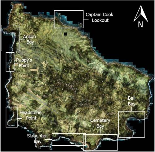
Norfolk Marine Park: Captain Cook Lookout, Anson Bay, Slaughter Bay, Cemetery and Emily Bay, Ball Bay, Puppy’s Point and Headstone Point.
Who
The coastal survey of Norfolk Island was managed by Ocean Infinity Pty Ltd, with the help and experience of Tellus4D for Drone photogrammetry survey, and Alysha Johnson (University of Wollongong) for data processing and the coastal geomorphology interpretation. The Norfolk Island Nearshore and Coastal habitat mapping project was funded by an ‘Our Marine Parks’ grant from the Australian Government.
 Alysha Johnson
Sites of November 2021 iXblue drone photogrammetry surveys. Base map from Gallant and Petheram (2020)
When
The drone survey took place in November 2021, following the bathymetric survey offshore Norfolk Island. The data was processed in January 2022 at the University of Wollongong. The geomorphic analysis was completed in October 2022 as part of the Final Report for the Norfolk Island Nearshore and Coastal Habitat mapping project.
Why
Norfolk Island sits like a triangle, with three main coastline exposures: North-East, West and South. These exposures affect the morphology of the island’s shore. Mapping with an aerial autonomous drone allows remote and exposed coastal sites around the island to be safely reached. The results obtained are critical to define the type of morphology encountered around the island to picture an initial overview. Prior to this project, Norfolk Marine Park dataset was limited to a terrestrial lidar survey from CSIRO (Gallant, 2020) and a nearshore seafloor classification from satellite bathymetry.
 Alysha Johnson
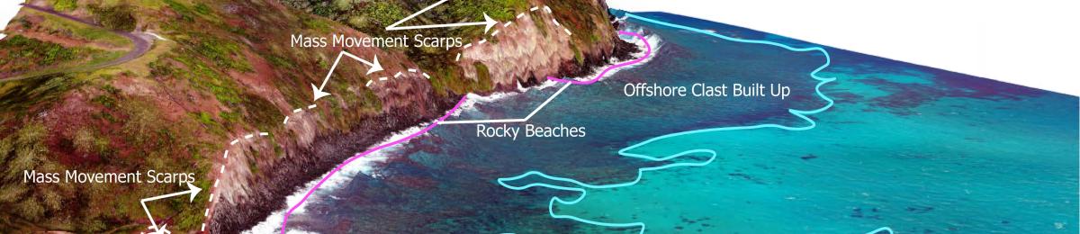
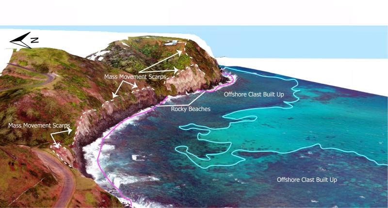
3D drone photogrammetry image of the eastern cliffs of Cemetery Bay. Extent of rocky beach and offshore sediment can be seen in conjunction with mass movements scarps.
How
The drone photogrammetry was performed with the drone Dji Mavic 2 pro set up with its built-in Hasselblad L1D-20c camera and its internal GNSS. The drone was operated from the shore. For each site, the flight plan was adjusted according to wind conditions on site and the coastline shape. The flight altitude was kept constant, resulting in flying altitude between 100 to 200m above ground. The data processing was performed with Agisoft and resulted in a Digital Elevation Model on which the photos were projected for 3D imagery. The results are 10cm resolution georeferenced mosaics with meter position accuracy. ArcGIS was used for the imagery analysis and interpretation.
What did we learn
The drone survey provides high resolution imagery of seven representative coastal sites around Norfolk Island. Through the imagery, the main geomorphological features have been defined to characterise the three main exposures of the island. The characteristics are highly constrained by the geological formation encountered on site, their response to weathering processes (waves and wind erosion) and their magnitude of mass wasting.
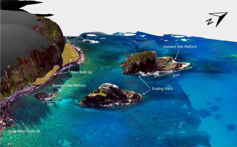
The North facing section of Norfolk Island, represented by Captain Cook Lookout, exhibits offshore stacks (such as Elephant and Bird Rock), dramatic cliffs and onshore and offshore platforms with pockets of rocky beaches.
The West side of the island, represented by Anson Bay, Puppy’s Point and Headstone Point, is exposed to Westerlies and Eastward waves. The three sites show predominant morphology made of basaltic shore platforms and rocky beach. The cliffs are shaped by cyclic retreat process with alternance of caves, boulder beaches and undercut sections. Some mass movements are observed on the top section of the cliffs.
The South side, represented by Slaughter Bay, Emily Bay and Cemetery Bay, and Ball Bay, shows two geological formations: a sedimentary rock (calcarenite) and a volcanic rock (basalt). Although the rocky beach and cliff remain the main morphologies, the South side of the island also offers the best sandy beaches. Natural wave breakers (such as Point Hunter in Cemetery Bay or calcarenite platform in Slaughter Bay) create calmer environments, facilitating the coral reef growth within Slaughter Bay.
On shore, several localised mass movements are observed, the largest being in the Kingston Region where the weathered basalt is prone to failure.
 Alysha Johnson
Oblique view of Captain Cook drone photogrammetry viewing the base of the cliffs and the sea stacks. The cliffs show build-up of talus slopes at their base, before transitioning into rocky beach and continuing clast deposits into the ocean. The stacks show clear horizontal platforms forming on their seaward side.
 Alysha Johnson
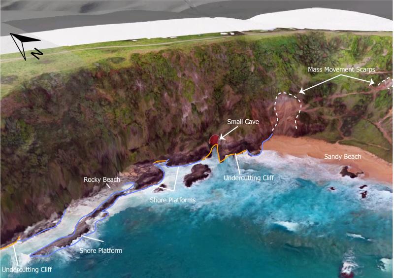
3D drone photogrammetry of the northern end of Anson Bay. The cliff shows evidence of undercutting and formation of small cave between sections of shore platform.
 Alysha Johnson
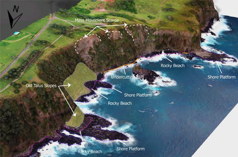
3D drone photogrammetry of Puppy’s Point showing mass wasting scarps and old talus slope build up. Platform is alternating shore platform, rocky beach and undercutting cliff.
What next
This drone photogrammetry survey and subsequent geomorphologic interpretation is the first of its kind in Norfolk Island region. This survey can be seen as an initial description of a sample of the island. To accurately understand and represent the coastal geomorphology of Norfolk Island, more sites, if not all, could be surveyed in the future. The high-resolution imagery and digital elevation models produced are a valuable baseline for future studies measuring the coastal changes around Norfolk Island as part of Onshore and Nearshore habitat mapping monitoring and management. It will help the the assessment and quantification of changes occurring on the coastline and guide appropriate action to conserve the coastal habitats of Norfolk Island.
 Alysha Johnson
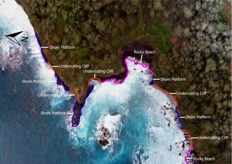
Section of Rocky Point/ Headstone Point cliff which cyclic pattern of shore platform formation, cliff undercutting and then rocky beach formation.
 Alysha Johnson
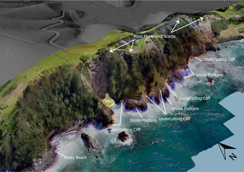
3D drone photogrammetry of basalt cliffs west of Kingston Jetty. Large mass movement scarps can be seen on the summit of the cliffs, whilst at the base, cliffs alternate between undercutting and shore platform formation.
 Alysha Johnson
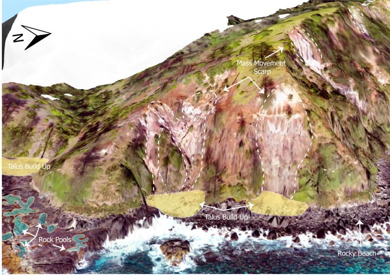
3D view of mass movements and platforms on the southwestern mouth of Ball Bay. Drone photogrammetry shows locations of talus slope build up the base of mass movement scarps. The platform in the lefthand side of the image shows natural formation of rock pools
Related data and publications
The project report can be found on the Norfolk Island Flora and Fauna web site here.
The data collected has also been used for the thesis of Alysha Johnson, University of Wollongong, with expected publication in October 2024.