
Datasets for: NERP TE Project 2.3 - Monitoring the health of Torres Strait coral reefs (AIMS)
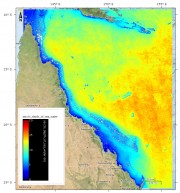
This dataset consists of daily estimates of photic depth on the Great Barrier Reef from MODIS satellite imagery (from 2002 - 2015) using a quasi-analytical algorithm. This algorithm is based on a Type II linear regression of log-transformed satellite and in situ data (2002- 2012).
This algorithm was developed as part of data delivery for several NERP projects and was implemented into the NASA SeaDAS tool for processing MODIS imagery. This algorithm and its data products are now routinely run by the Bureau of Meteorology as part of the eReefs Water Quality Dashboard.
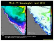
The Biophysical Oceanography Group produces monthly oceanographic reports for the eastern Australian coast, including the Torres Strait, which summarise key environmental variables such as sea surface temperature (SST) and chlorophyll concentration. These variables are important indicators for coral reef ecosystems and other biological processes.
This series of the reports covers from August 2011 - November 2014
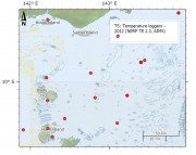
As part of the NERP TE project 2.3 temperature loggers were deployed at 15 sites across Torres Strait to measure the sea temperature. The loggers regularly measure the sea water temperature and record it in their memory. Every year or so the loggers are swapped with new loggers and the recorded data is extracted and recorded in the AIMS Real Time Data Systems database as part of the Australia wide Sea Temperature Observing System.
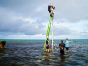
The data consists of ten minute readings of above water meteorological parameters (wind speed, wind direction, barometric pressure, air temperature and humidity) from a Vaisala WTX520 instrument, above water light as Photosynthetically Active Radiation (PAR) from a Li-COR Li-192 sensor and below water parameters including Salinity using a Sea-Bird SBE37 CTD and temperature via a Sea-Bird SBE39 temperature sensor. Data are from two sites, one at Madge Reef near Thursday Island (-10.595125° | 142.220572°) and one at Masig (Yorke) Island (-9.758293° | 143.397584°).

This project will conduct a biodiversity assessment of coral communities on Torres Strait reefs to establish a baseline of coral condition and start a longer-term monitoring program of selected coral reefs in the region. The monitoring will look for changes in the condition of coral reefs and document factors that might contribute to changes incl COTS, disease, bleaching, temperature anomalies etc. As part of this project, an early warning system will be established for coral bleaching.
This project conducted a biodiversity assessment of coral communities on Torres Strait reefs to establish a baseline of coral condition and start a longer-term monitoring program of selected coral reefs in the region. The monitoring looked for changes in the condition of coral reefs and documented factors that might contribute to changes including COTS, disease, bleaching, temperature anomalies etc. As part of this project, an early warning system was established for coral bleaching.