Description
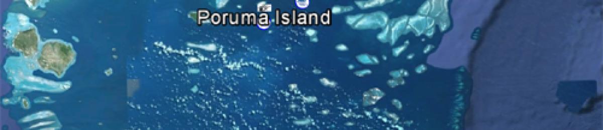
Torres Strait map
As part of Project 2.3 broadscale surveys and biodiversity assessments were conducted in the central island group and eastern island group within the Torres Strait region.
Manta tow (broadscale surveys)
Broadscale surveys were conducted by manta tow in February 2013 at Aureed Island Reef, Aukane Island Reef, Kabbikane Island Reef, Masig Island Reef, Mer Island Reef and Waier and Dauar Island Reef.
Biodiversity surveys
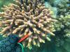
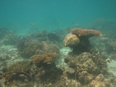
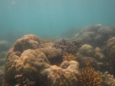
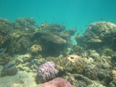
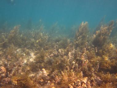
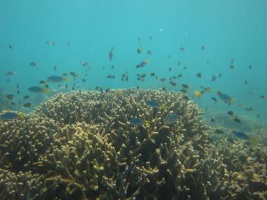
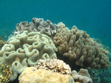
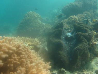
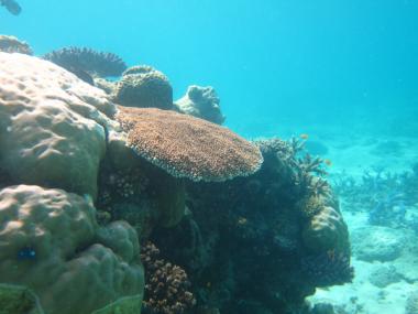
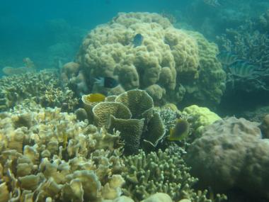
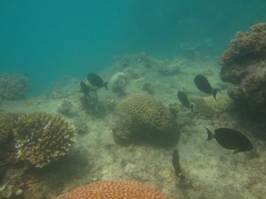
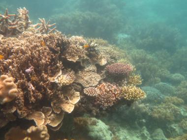
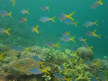
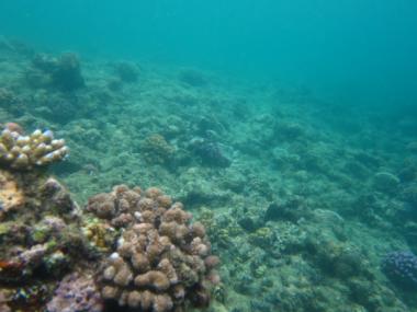
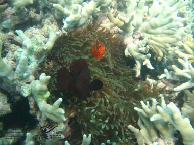
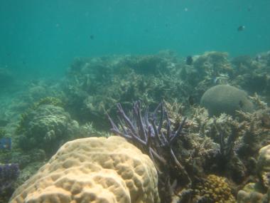
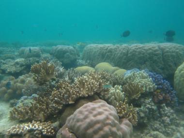
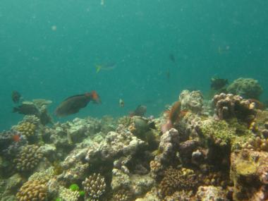
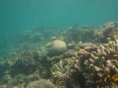
Lists of scleractinian coral species and fish species were collected in February 2013 at Poruma Island Reef, Aureed Island Reef, Masig Island Reef, Erub Island Reef and Mer Island Reef, shown in the image below. Species level photos were collected.
Manta Tow:
Fish and Benthos Surveys:
RHIS surveys:
View the following reef pages to see detailed results of broadscale surveys and benthic community cover from photo transects and RHIS surveys:
Fish and hard coral biodiversity surveys
The results of biodiveristy surveys are published in (Ref) For methods used and a list of fish species observed within the Torres Strait region by CSIRO in 2007 and additional records from the survey in 2013, please refer to the appendicies in the report.
Surveys of reef benthos
Photo transects
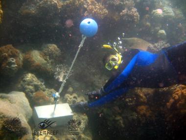
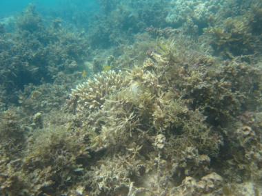
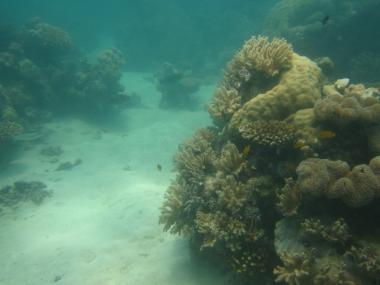
Photo transects were taken in representative habitats on each island to provide context for the biodiversity assessments and to establish baseline data on benthic community composition. Habitats sampled included the reef flat, reef crest, reef slope and lower reef slope. The depth range of the reef slope varied from the central to eastern islands. The lower slope transects was near the base of the reef slope. The slope transects were typically around 4-6 meters depth but were not located randomly, as areas of higher coral cover were being targetted for the biodiversity surveys. In patchy habitats the estimates of cover would be expected to be higher than if transects were randomly located. The standard methods established by the AIMS long term monitoring project (LTMP) were modified for the surveys in Torres Strait and are outlined below.
At each site, 3 x 10m transects were laid out and sampled by taking a photograph of the substrate at 50cm intervals from a distance of 50cm from the substrate, giving a total of 20 photos per transect. The benthos were analysed using image analysis software developed for the LTMP at AIMS. On each photograph, benthos were identified under 5 points arranged in a quincunx, resulting in 100 samples of benthos per transect and this data was converted to percent cover (%).
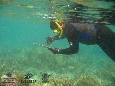
Reef Health Impact Surveys
As well as the photo transects mentioned above, Reef Health Impact Surveys (RHIS) sites were established and surveyed in the zone of the reef crest or the shallower part of the reef slope(2-3m). RHIS are part of the Great Barrier Reef Marine Park Authority's (GBRMPA) Eye on the Reef Program, and are intended to be a quick and efficient way to provide a snapshot of reef health at any time, on any reef. In Torres Strait the sites established in 2013 will be monitored by Torres Strait Regional Authority (TSRA) rangers who were trained by GBRMPA staff during the trip.
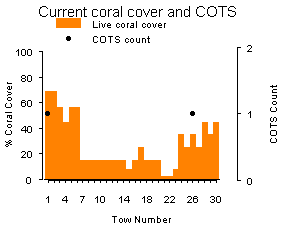
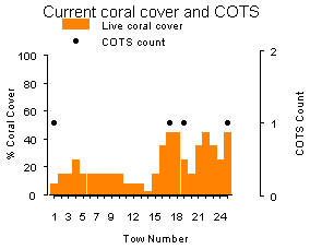
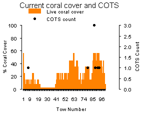
This page links to a summary page for each reef surveyed in 2013. Summaries of broadscale surveys for each reef included an aerial image of the reef, graphs showing the median percent coral per tow and the number of Acanthaster planci or crown-of-thorns-starfish (COTS) per tow, as well as a text summary. Summaries of benthos for each reef included: site locations, photos of the benthos, graphs showing estimates of main groups of benthos, hard coral families (crest, slope and lower slope) and types of algae (reef flat) and text summarising major trends. Summaries for RHIS sites included graphs for percent cover of hard coral and soft coral.
Aukane Reef
Surveyed 25-Feb-2013 as part of the NERP-TE Project 2.3
Description
Aukane Reef back
Description
Aukane Reef first flank
Description
Aukane Reef front
Description
Aukane Reef second flank
Aukane Island Reef was surveyed for the first time using manta tow in 2013. Median reef-wide live coral cover was moderate (10-20%) and small numbers of crown-of-thorns starfish were recorded below outbreak levels. Signs of white syndrome were restricted to small numbers of individual colonies on the back and flanks of the reef perimeter during surveys in 2013. No bleaching or signs of black band disease were observed. Aukane Island Reef was classified as No Outbreak.
Manta Tow:
Fish and Benthos Surveys:
RHIS surveys:
Aukane Reef Perimeter Hard Coral Crown-of-thorns starfish graph.
Aureed Reef
Description
Aureed Reef back
Description
Aureed Reef first flank
Description
Aureed Reef front
Description
Aureed Reef second flank
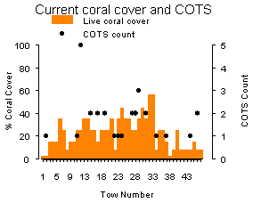
Aureed Island Reef was surveyed for the first time using manta tow in 2013. Median reef-wide live coral cover was moderate (20-30%) and numbers of crown-of-thorns starfish were recorded at outbreak levels that may have some impact on coral cover. Signs of coral bleaching were restricted to small numbers of individual colonies on the back of the reef. No signs of black band disease or white syndrome were observed. Aureed Island Reef was classified as Incipient Outbreak in 2013.
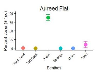
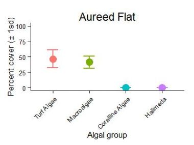
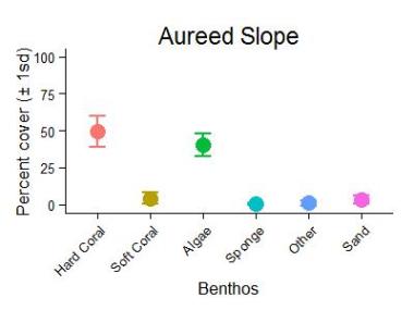
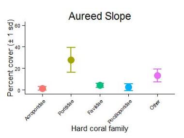
The survey sites were located on the reef flanks where the most continuous area of hard substrate was found. The reef slope was short and after 20-30 m the reef substrate transitioned to sand at around 6-9 m depth. Hard coral cover on the shallow reef slope was patchy with estimates from Reef Health and Impact Surveys (RHIS) being very variable between sites. Hard coral cover was moderate to very high (14-62%) , while soft coral cover was low to moderate (2-12%). Photo transects were sampled from the reef flat and the reef slope at Aureed Island Reef. The reef flat was dominated by extremely high cover of algae (88%), composed of brown macroalgae (41%) and turfing algae (47%). The remainder of the benthos was mostly sand (10%). On the reef slope hard coral cover was high at 50%. Poritidae was the dominant hard coral family with 28% cover, followed by the mixed family group at 13% and Faviidae at 4%. Soft coral abundance was low (4%). Algal cover was high (40%), composed predominantly of turfing algae (37%).
Manta Tow:
Fish and Benthos Surveys:
RHIS surveys:
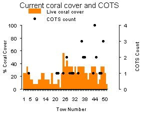
Aureed Reef Perimeter Hard Coral Crown-of-thorns starfish graph.
Description
Aureed Flat Slope Benthic Group Graph
Description
Aureed Reef Flat Algae Graph
Description
Aureed Reef Slope Benthic Group Graph
Description
Aureed Reef Slope Hard Coral Families Graph
Erub Reef
Surveyed 25-Feb-2013 as part of the NERP-TE Project 2.3
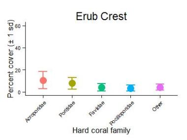
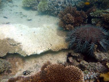
There were no manta tow surveys at Erub Island Reef in 2013. At Erub Island Reef there was some formation of a reef crest community. One site (Site 3) that was located on the seaward edge of a broad reef flat had a more exposed setting. Estimates of coral cover on the reef crest from Reef Health and Impact Surveys (RHIS) averaged 21% for hard coral and 28% for soft coral on sites 1 and 2 that were close to the island and 50% for hard coral and 3% for soft coral on the seaward more exposed site.
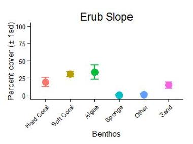
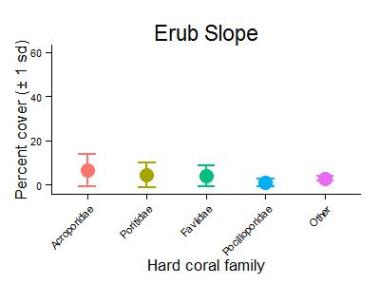
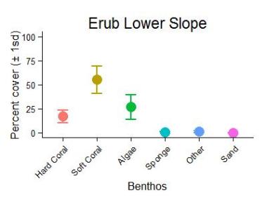
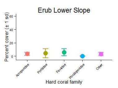
Photo transects of the benthos were sampled from the reef crest, reef slope and the lower reef slope at Erub Island Reef. Hard coral cover was moderate in all habitats (17-30%), declined with depth and was quite variable within sites (17-38%). In each habitat hard coral families all had cover equivalent to 10% or less. Soft coral abundance increased with depth. Soft coral cover was moderate on the crest and slope, whilst very high (55%) on the lower slope and was composed almost exclusively of Alcyoniidae. Algal cover was highest on the crest and slope (34-36%) and lowest on the lower slope (27%) was composed almost entirely of turf algae (25-32%). The cover of sand was moderate on the slope habitat at 14%, but negligible on the crest and lower slope."
Manta Tow:
Fish and Benthos Surveys:
RHIS surveys:

Description
Erub Reef Crest Benthic Group Graph
Description
Erub Reef Crest Hard Coral Families Graph
Description
Erub Reef Slope Benthic Group Graph
Description
Erub Reef Slope Hard Coral Families Graph
Description
Erub Reef Lower Slope Benthic Group Graph
Description
Erub Reef Lower Slope Hard Coral Families Graph
Kabbikane Reef
Surveyed 25-Feb-2013 as part of the NERP-TE Project 2.3
Description
Kabbikane Reef back
Description
Kabbikane Reef first flank
Description
Kabbikane Reef front
Description
Kabbikane Reef second flank
Kabbikane Island Reef was surveyed for the first time using manta tow in 2013. Median reef-wide live coral cover was moderate (10-20%) and small numbers of crown-of-thorns starfish were recorded below outbreak levels. Signs of white syndrome were restricted to small numbers of individual colonies on the first flank during surveys in 2013. No bleaching or signs of black band disease were observed. Kabbikane Island Reef was classified as No Outbreak.
Manta Tow:
Fish and Benthos Surveys:
RHIS surveys:
Kabbikane Reef Perimeter Hard Coral Crown-of-thorns starfish graph.
Masig Reef
Surveyed 20-Feb-2013 as part of the NERP-TE Project 2.3
Description
Masig Reef back
Description
Masig Reef first flank
Description
Masig Reef front
Description
Masig Reef second flank
Masig Island Reef was surveyed for the first time using manta tow in 2013. Median reef-wide live coral cover was moderate (10-20%) and small numbers of crown-of-thorns starfish were recorded below outbreak levels. Signs of white syndrome and coral bleaching were restricted to small numbers of individual colonies on the back reef during surveys in 2013. No signs of black band disease were observed. Masig Island Reef was classified as No Outbreak.
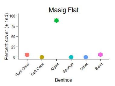
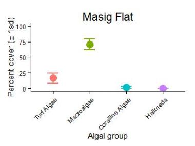
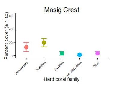
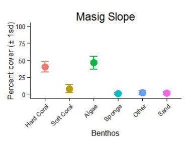
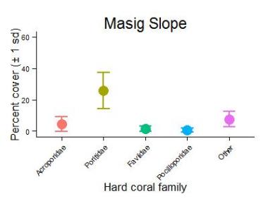
At Masig Island Reef there was some formation of a reef crest community and in some places the coral community extended down the reef slope to 10-12m. Estimates of coral cover on the reef crest from Reef Health and Impact Surveys (RHIS) averaged 27% for hard coral and 7% for soft coral. Photo transects were sampled from the reef flat, the reef crest and the reef slope at Masig Island Reef. The reef flat was dominated by extremely high cover of algae, composed of brown macroalgae (71%) and turfing algae (16%). Sand covered 6% of the reef flat whilst hard coral covered 5% on the reef flat. Poritidae, Acroporidae and Pocilloporidae occupied 2%, 1% and 1% of the reef flat benthos. There was no soft coral on the reef flat. The reef crest and reef slope were similar with around 40% hard coral cover, but had a different composition. Poritidae was the dominant hard coral family with 20% on the reef crest and 26% cover on the slope. The reef crest had higher cover of Acroporidae (13%) and Faviidae (4%) than the reef slope (4% and 1% respectively). On the reef slope other hard coral families covered 8% of the benthos. Soft coral cover was similar between the reef crest (8%) and the reef slope (10%). Soft coral was predominantly composed of Alcyoniidae and was variable between sites on the reef crest (6-15%) and reef slope (5-12%). The algal community had moderate cover, composed predominantly of turf algae.
Manta Tow:
Fish and Benthos Surveys:
RHIS surveys:
Masig Reef Perimeter Hard Coral Crown-of-thorns starfish graph.
Description
Masig Flat Slope Benthic Group Graph
Description
Masig Reef Flat Algae Graph

Description
Masig Reef Crest Benthic Group Graph
Description
Masig Reef Crest Hard Coral Families Graph
Description
Masig Reef Slope Benthic Group Graph
Description
Masig Slope Crest Hard Coral Families Graph
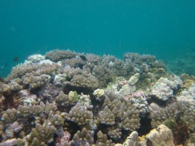
Mer Island Reef
Surveyed 25-Feb-2013 as part of the NERP-TE Project 2.3
Description
Mer Reef back
Description
Mer Reef first flank
Description
Mer Reef front
Description
Mer Reef second flank
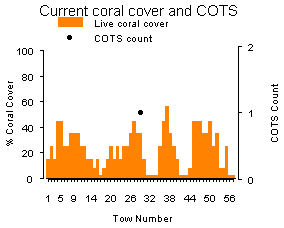
Mer Island Reef was surveyed for the first time using manta tow in 2013. Median reef-wide live coral cover was moderate (20-30%) and small numbers of crown-of-thorns starfish were recorded below outbreak levels. Signs of coral bleaching were restricted to small numbers of individual colonies scattered around the reef perimeter during surveys in 2013. Signs of white syndrome disease were observed on small numbers of individual scattered coral colonies on the first flank and front of the reef. White syndrome was common on the back reef where it affected more than ten colonies per two minute manta tow. No signs of black band disease were observed. Mer Island Reef was classified as No Outbreak.
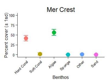
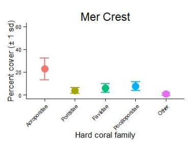
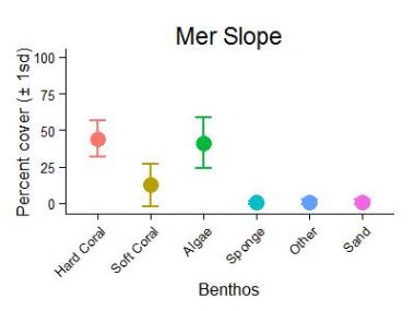
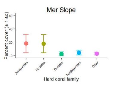
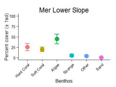
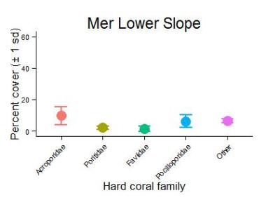
Structural heterogeneity of the reef was higher than other reefs sampled in the Torres Strait region. There was a distinct reef crest and greater diversity of reef slope habitats around the island. Estimates of coral cover on the reef crest from Reef Health and Impact Surveys (RHIS) were variable both within and between sites. Hard coral ranged from 2-48% and soft coral from less than !% to 55%. Photo transects were sampled from the reef crest, the reef slope and the lower reef slope at Mer Island Reef. The reef crest and reef slope habitats had similar hard coral cover (41% and 44% respectively) while the lower reef slope had 25% cover. The composition of the hard coral assemblages differed between the three habitats. Acroporidae (23%) was the dominant hard coral family on the reef crest site followed by Pocilloporidae (8%), Faviidae (6%) and Poritidae (4%). On the reef slope Acroporidae and Poritidae were equally abundant at 18% while Pocilloporidae had 4%. On the lower reef slope Acroporidae was the most dominant family with 10% cover, followed by Pocilloporidae (6%), a mixture of families (6%), Poritidae (2%) and Faviidae (1%). Soft coral cover, predominantly composed of Alcyoniidae, increased with depth from 2% on the reef crest to 20% on the lower slope and was variable between sites. The algae community was high (41- 56% cover), fairly consistent between habitats and was composed of turfing algae (31%) and coralline algae (13%).
Manta Tow:
Fish and Benthos Surveys:
RHIS surveys:
Description
Mer Reef Crest Benthic Group Graph
Description
Mer Reef Crest Hard Coral Families Graph
Description
Mer Reef Slope Benthic Group Graph
Description
Mer Reef Slope Hard Coral Families Graph
Description
Mer Reef Lower Slope Benthic Group Graph
Description
Mer Reef Lower Slope Hard Coral Families Graph
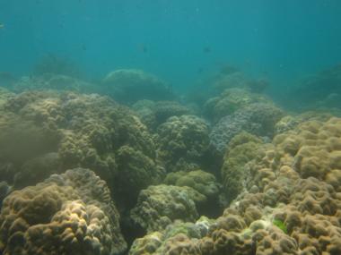
Poruma Reef
Surveyed 25-Feb-2013 as part of the NERP-TE Project 2.3
Description
Poruma Reef
Description
Poruma Reef
Description
Poruma Reef
Description
Poruma Reef
There were no manta tow surveys at Poruma Island Reef in 2013 due to poor visibility.
The shallow reef flat areas at Poruma Island Reef were dominated by brown macroalgae. The reef slope was short and after 20-30 m the reef substrate transitioned to sand at around 6-9 m depth. Coral cover on the shallower part of the reef slope was patchy. Estimates of coral cover from Reef Health and Impact Surveys (RHIS) were from 7-24% for hard coral and from 9-38% for soft coral.
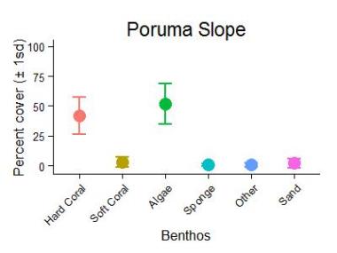
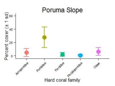
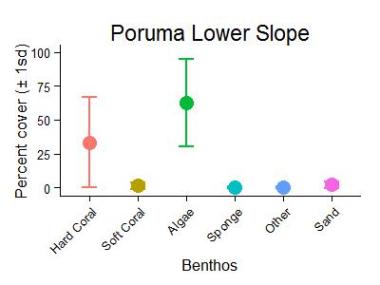
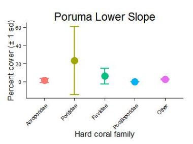
Benthos were sampled using photo transects on the reef slope and the lower reef slope at Poruma Island Reef. Hard coral cover was high in both habitats, but was higher (42%) on the slope than the lower slope (33%). The hard coral community was dominated by Poritidae (23-28%) with other families accounting for 6% or less of the benthic cover. Soft coral abundance was very low (<3%). Algal cover was higher on the lower slope (63%) than the slope (52%) and was composed almost entirely of turf algae.
Manta Tow:
Fish and Benthos Surveys:
RHIS surveys:
Description
Poruma Reef Slope Benthic Group Graph
Description
Poruma Reef Slope Hard Coral Families Graph
Description
Poruma Reef Lower Slope Benthic Group Graph
Description
Poruma Reef Lower Slope Hard Coral Families Graph
Waier and Dauar Reef
Surveyed 24-Feb-2013 as part of the NERP TE Project 2.3
Description
Waier And Dauar Reef back
Description
Waier And Dauar Reef first flank
Description
Waier And Dauar Reef front
Description
Waier And Dauar Reef second flank
Waier and Dauar Island Reef was surveyed for the first time using manta tow in 2013. Median reef-wide live coral cover was moderate (20-30%) and numbers of crown-of-thorns starfish were recorded at outbreak levels that may have some impact on coral cover. Signs of coral bleaching were restricted to small numbers of individual colonies on the second flank of the reef. Similar low level signs of white syndrome were observed on scattered coral colonies on the back, front and second flank of the reef. No signs of black band disease observed. Waier and Dauar Island Reef was classified as Incipient Outbreak in 2013.
There were no photo transects collected but estimates from one Reef Health and Impact Surveys (RHIS) site on the reef crest at Dauar indicated that hard coral cover was high (68%) and soft coral was low (2%). RHIS indicated COTS and some coral diseases were present.
Manta Tow:
Fish and Benthos Surveys:
RHIS surveys:
Waier and Dauar Reef Perimeter Hard Coral Crown-of-thorns starfish graph.
Related content