
eAtlas (Australian Institute of Marine Science)
Articles
Published on 30 January 2019
This presentation provides an introduction to the concepts needed by content editors of eAtlas.
Published on 1 September 2015
This technical presentation provides an introduction to the aim of the eAtlas as well as a comphensive overview of the design and architecture of the eAtlas systems.
Published on 8 November 2014
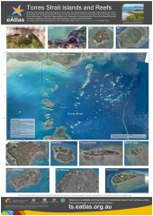
This poster map shows satellite and aerial imagery of Torres Strait. It also shows the Australia Maritime Boundariers in the region. This region neighbours with Papau New Guinea resulting in complex maritime boundaries.
Published on 8 November 2014
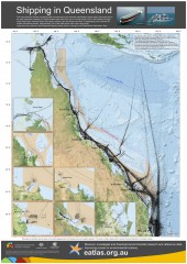
This map shows the density of shipping traffic as measured by the Automatic Identification System (AIS). Each black dot on the map represents a reading of a vessel location taken each hour over a 3 month period in 2013. AIS is fitted to all large ships (cargo ships, container ships, bulk carriers, tankers, etc) and ferries (more than 12 passengers) and is optional for smaller recreational vessels.
Published on 25 September 2014

The Winds of Zenadth Cultural Festival takes place every two years on Thursday Island. The festival is a community event that brings people together and showcases the strength and diversity of the Torres Strait people’s culture and customs.
The eAtlas information stall at the festival in September 2014, provided an opportunity for the community to try out the mapping and visualisation tools and to get familiar with the look and feel of the site. The most important message for the community was that the Torres Strait eAtlas is an internet site that is free for everyone to use.