Dr Michelle Devlin
Author of

There is an updated version of the details of this part of the MMP monitoring program.

As part of its commitment under Theme 5 of the MTSRF, the Reef and Rainforest Research Centre publishes, or makes available, outputs (e.g. final technical or scientific reports, synthesis reports) from MTSRF-funded research projects nested within Research Themes 1-4.
This report provides an overview of the key findings of research conducted through the Marine and Tropical Sciences Research Facility (MTSRF) designed to improve our understanding of the linkages between catchment and reef processes, and how the quality of water from paddock, sub-catchment, catchment and marine systems can directly and indirectly influence the ecological functioning of the Great Barrier Reef (GBR). The research aimed to inform and facilitate management action and remediation to reduce, restore and increase resilience of the inshore GBR ecosystems. The research findings are also applicable elsewhere, particularly in tropical ecosystems, but many outcomes can be translated for broader application in catchment and marine ecosystem management.

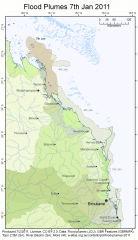
This page shows the extent of the flood plumes of the Fitzroy, Burnett, Mary and Brisbane Rivers caused by the extensive flooding that occurred in Queensland in December 2010 and January 2011. These flood plume maps were produced as part of the Reef Rescue Marine Monitoring Program - Assessment of terrestrial run-off entering the Great Barrier Reef project by James Cook University (contact Michelle Devlin). They were based on visual inspection of NASA MODIS satellite images and were created for days where the cloud cover was low enough to see the boundary of the plumes.


