Dr Glenn De'ath
Author of

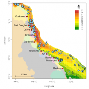
This article outlines the use of two R packages, geoMap and geo, developed to analyse data and generate outputs for the e-atlas and ningaloo-atlas. geoMap generates a variety of plots that can be used for exploratory analysis, presentations and publication-quality maps. geo is an extensive set of spatial modelling techniques that produces fitted surfaces that can be added to publication graphics, or added to the e-atlas as layers, or used as KMLs.

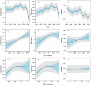
Reef-building corals are under increasing physiological stress from a changing climate and ocean absorption of increasing atmospheric CO2. We investigated 328 colonies of massive Porites corals from 69 reefs of the Great Barrier Reef (GBR). Their skeletal records show that throughout the GBR, calcification has declined by 14.2% since 1990, predominantly due to extension declining by 13.3%. The data suggest such a severe and sudden decline in calcification is unprecedented in at least the last 400 years. Calcification increases linearly with increasing large-scale sea surface temperature, but responds non-linearly to annual temperature anomalies. The causes for the decline remain unknown, however this study suggests that increasing temperature stress and declining seawater aragonite saturation state may be diminishing the ability of GBR corals to deposit calcium carbonate.


