NESP TWQ Round 3 - Project 3.3.3 - Defining the values of the ecological systems that influence the GBR and lie outside the marine park and world heritage area boundaries
The Great Barrier Reef World Heritage Area (GBRWHA), globally recognised for its outstanding universal value, is an integrated and highly connected part of a larger northeast Australia marine bioregion, which includes Torres Strait, the Coral Sea and the Great Sandy Marine Park (Hervey Bay). Understanding the values (ecological, cultural, social and economic) of these adjacent systems, and especially the connections and interdependencies between systems, is crucial to effective and efficient protection and management of the globally important natural and cultural values within each system. This project identified and assessed the values of these adjacent systems, and characterised the processes and attributes that influence the values and their connectivity at a regional scale, delivering a resource that can inform cross-jurisdictional planning and management.
This project developed the Connectivity of North East Australia's Seascape website that contains articles highlighting the importance of connectivity for key values along with maps showing the strengths of the connections between the GBR and it surrounding regions.
Find NESP TWQ 3.3.3 project reports and fact sheets on the NESP TWQ Hub website.
Images
Datasets

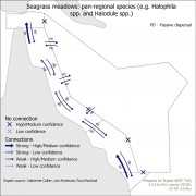
This dataset shows the results of mapping the connectivity of key values (natural heritage, indigenous heritage, social and historic and economic) of the Great Barrier Reef with its neighbouring regions (Torres Strait, Coral Sea and Great Sandy Strait). The purpose of this mapping process was to identify values that need joint management across multiple regions.
It contains a spreadsheet containing the connection information obtained from expert elicitation, all maps derived from this information and all GIS files needed to recreate these maps.


